
Magnitude |
3.1 |
| Date & Time (UTC) | 2015-07-22 01:57:46.1 |
| Date & Time (Local) | 1394/4/31 06:27:46.1 |
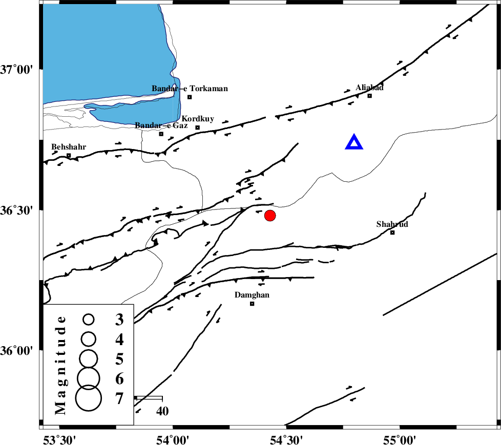
| Location | Lat:36.48 Lon: 54.428 |
| Region | Semnan Province, 40 km South of Gorgan |
Nearest Cities |
|
| 8 km of Cheharbagh, Golestan Province | |
| 20 km North West of Majen, Semnan Province | |
| 21 km South of Naharkhoran, Golestan Province | |
| 31 km North West of Mehmandust, Semnan Province | |
| 36 km North of Damghan, Semnan Province | |
| Depth | 15 km |
| Agency | |
Faults within 150 km: |
|
| ASTANEH_F (Length: 72 km) , Distance to epicenter: 5 km | |
| SHAVAR_F (Length: 87 km) , Distance to epicenter: 10 km | |
| N_ALBORZ_F (Length: 360 km) , Distance to epicenter: 15 km | |
| Number of Phases | 8 |
| RMS | 0.1 |
| Number of Stations | 7 |
| Error in Latitude | >1.8 km |
| Error in Longitude | 3.7 km |
| Error in Depth | 9.7 km |
Download waveform in seisan format
to download seisan software Click here
to access information about IIEES stations Click here
Amplitude | ||||||||
| UID | Agency | Station | Component | Amplitude | Period | Arrival Time | Proccessing Time | Signal Clip |
| 100154 | IIEES | SHRO | E | 381.1 | 0.38 | 2015-07-22 01:58:34 | 2015-07-22 08:16:00 | n |
| 100155 | IIEES | NASN | N | 21.9 | 0.23 | 2015-07-22 01:59:48 | 2015-07-22 08:16:00 | n |
Phase | ||||||||||||
| Agency | Station | Component | Phase Type | Phase Quality | First Motion | Observed Arrival Time | Time Residual | Loc. Flag | Input Weight | Distance | Azimuth | |
| IIEES | SHRO | Z | Pg | E | 2015-07-22 01:58:11 | -0.05 | y | 152 | 110 | |||
| IIEES | SHRO | N | Sg | E | 2015-07-22 01:58:29 | 0.06 | y | 152 | 110 | |||
| IIEES | MRVT | Z | P | E | 2015-07-22 01:58:17 | -0.03 | y | 197 | 48 | |||
| IIEES | DAMV | Z | Pn | E | 2015-07-22 01:58:23 | -0.04 | y | 241 | 248 | |||
| IIEES | CHTH | Z | Pn | E | 2015-07-22 01:58:31 | 0.13 | y | 304 | 259 | |||
| IIEES | THKV | Z | Pn | E | 2015-07-22 01:58:34 | -0.01 | y | 325 | 260 | |||
| IIEES | GHVR | Z | Pn | E | 2015-07-22 01:58:39 | 0 | y | 364 | 233 | |||
| IIEES | NASN | Z | Pn | E | 2015-07-22 01:58:47 | -0.07 | y | 434 | 200 | |||