
Magnitude |
3.3 |
| Date & Time (UTC) | 2015-07-29 08:47:08.3 |
| Date & Time (Local) | 1394/5/7 13:17:08.3 |
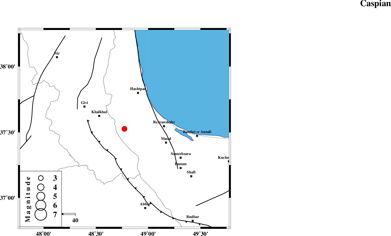
| Location | Lat:37.526 Lon: 48.773 |
| Region | Gilan Province, 24 km -East of Khalkhal |
Nearest Cities |
|
| 10 km West of Ardeh, Gilan Province | |
| 16 km North of Kalur, Ardebil Province | |
| 21 km East of Khojin, Ardebil Province | |
| 21 km North of Shal, Ardebil Province | |
| 24 km East of Khalkhal, Ardebil Province | |
| Depth | 14 km |
| Agency | |
Faults within 150 km: |
|
| MASULEL_F (Length: 90 km) , Distance to epicenter: 24 km | |
| TALESH_F (Length: 258 km) , Distance to epicenter: 29 km | |
| SANGAVAR_F (Length: 61 km) , Distance to epicenter: 43 km | |
| Number of Phases | 6 |
| RMS | 0.2 |
| Number of Stations | 3 |
| Error in Latitude | >1.4 km |
| Error in Longitude | 3 km |
| Error in Depth | 5.9 km |
Download waveform in seisan format
to download seisan software Click here
to access information about IIEES stations Click here
Amplitude | ||||||||
| UID | Agency | Station | Component | Amplitude | Period | Arrival Time | Proccessing Time | Signal Clip |
| 100209 | IIEES | GRMI | N | 414.8 | 0.22 | 2015-07-29 08:47:56 | 2015-07-29 11:41:00 | n |
| 100210 | IIEES | GRMI | E | 497.6 | 0.24 | 2015-07-29 08:47:56 | 2015-07-29 11:41:00 | n |
Phase | ||||||||||||
| Agency | Station | Component | Phase Type | Phase Quality | First Motion | Observed Arrival Time | Time Residual | Loc. Flag | Input Weight | Distance | Azimuth | |
| IIEES | ZNJK | Z | Pg | E | 2015-07-29 08:47:24 | 0.22 | y | 95.2 | 185 | |||
| IIEES | ZNJK | E | Sg | E | 2015-07-29 08:47:36 | -0.13 | y | 95.2 | 185 | |||
| IIEES | GRMI | Z | Pg | E | 2015-07-29 08:47:34 | -0.19 | y | 162 | 332 | |||
| IIEES | GRMI | N | Sg | E | 2015-07-29 08:47:54 | 0.07 | y | 162 | 332 | |||
| IIEES | CHTH | Z | Pn | E | 2015-07-29 08:47:50 | 0.15 | y | 276 | 130 | |||
| IIEES | CHTH | E | Sg | E | 2015-07-29 08:48:26 | -0.12 | y | 276 | 130 | |||