
Magnitude |
3.7 |
| Date & Time (UTC) | 2015-08-23 20:54:27.0 |
| Date & Time (Local) | 1394/6/2 01:24:27.0 |
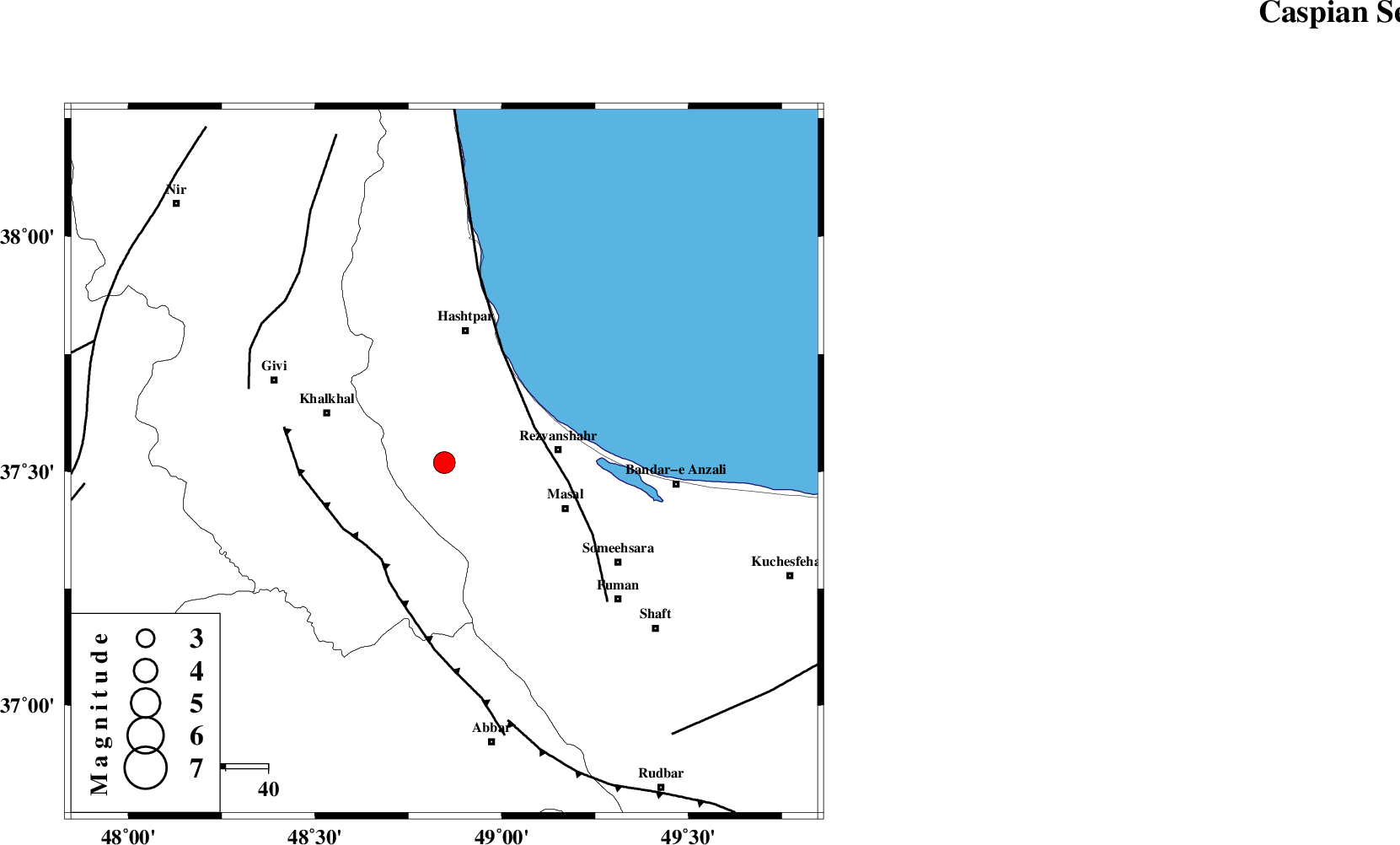
| Location | Lat:37.519 Lon: 48.846 |
| Region | Gilan Province, 27 km -West of Rezvanshahr |
Nearest Cities |
|
| 5 km of Ardeh, Gilan Province | |
| 18 km North East of Kalur, Ardebil Province | |
| 21 km West of Parrehsar, Gilan Province | |
| 21 km North of Shal, Ardebil Province | |
| 23 km West of Void, Gilan Province | |
| Depth | 15 km |
| Agency | |
Faults within 150 km: |
|
| TALESH_F (Length: 258 km) , Distance to epicenter: 23 km | |
| MASULEL_F (Length: 90 km) , Distance to epicenter: 27 km | |
| SANGAVAR_F (Length: 61 km) , Distance to epicenter: 49 km | |
| Number of Phases | 9 |
| RMS | 0.5 |
| Number of Stations | 6 |
| Error in Latitude | >3.4 km |
| Error in Longitude | 6.5 km |
| Error in Depth | 9.4 km |
Download waveform in seisan format
to download seisan software Click here
to access information about IIEES stations Click here
Amplitude | ||||||||
| UID | Agency | Station | Component | Amplitude | Period | Arrival Time | Proccessing Time | Signal Clip |
| 100434 | IIEES | GRMI | E | 517 | 0.2 | 2015-08-23 20:55:15 | 2015-08-24 05:53:00 | n |
| 100435 | IIEES | GHVR | N | 230.8 | 0.45 | 2015-08-23 20:56:30 | 2015-08-24 05:53:00 | n |
Phase | ||||||||||||
| Agency | Station | Component | Phase Type | Phase Quality | First Motion | Observed Arrival Time | Time Residual | Loc. Flag | Input Weight | Distance | Azimuth | |
| IIEES | ZNJK | Z | Pg | E | 2015-08-23 20:54:43 | 0.36 | y | 95.2 | 189 | |||
| IIEES | ZNJK | N | Sg | E | 2015-08-23 20:54:55 | 0.02 | y | 95.2 | 189 | |||
| IIEES | GRMI | Z | Pg | E | 2015-08-23 20:54:54 | 0.01 | y | 166 | 330 | |||
| IIEES | GRMI | N | Sg | E | 2015-08-23 20:55:14 | -0.08 | y | 166 | 330 | |||
| IIEES | CHTH | Z | Pn | E | 2015-08-23 20:55:09 | 1.05 | y | 271 | 131 | |||
| IIEES | CHTH | E | Sg | E | 2015-08-23 20:55:43 | -0.32 | y | 271 | 131 | |||
| IIEES | SNGE | Z | Pn | E | 2015-08-23 20:55:11 | -0.31 | y | 301 | 207 | |||
| IIEES | DAMV | Z | Pn | E | 2015-08-23 20:55:18 | 0.01 | y | 349 | 126 | |||
| IIEES | GHVR | Z | Pn | E | 2015-08-23 20:55:23 | -0.94 | y | 400 | 147 | |||