
Magnitude |
4.1 |
| Date & Time (UTC) | 2015-09-16 19:12:18.8 |
| Date & Time (Local) | 1394/6/25 23:42:18.8 |
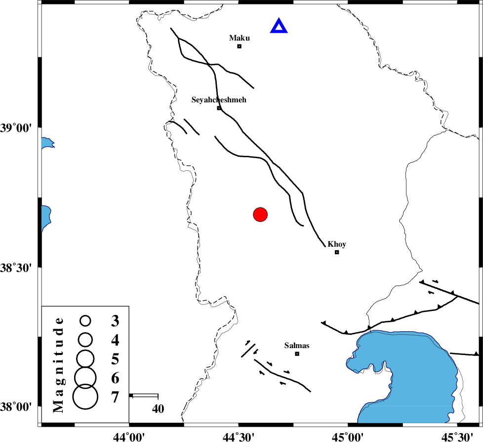
| Location | Lat:38.689 Lon: 44.599 |
| Region | Azarbaijan Gharbi Province, 34 km North-West of Khoy |
Nearest Cities |
|
| 11 km North East of Baleh sur-e sofla, Azarbaijan Gharbi Province | |
| 15 km South of Zarabad, Azarbaijan Gharbi Province | |
| 24 km North West of Beyk sofla, Azarbaijan Gharbi Province | |
| 28 km North East of Gatur, Azarbaijan Gharbi Province | |
| 31 km North West of Dizaj, Azarbaijan Gharbi Province | |
| Depth | 14 km |
| Agency | |
Faults within 150 km: |
|
| KHOY (Length: 100 km) , Distance to epicenter: 16 km | |
| N_TABRIZ_F3 (Length: 66 km) , Distance to epicenter: 49 km | |
| SALMAS (Length: 20 km) , Distance to epicenter: 52 km | |
| Number of Phases | 4 |
| RMS | 0 |
| Number of Stations | 3 |
| Error in Latitude | >6.5 km |
| Error in Longitude | 4.9 km |
| Error in Depth | 9 km |
Download waveform in seisan format
to download seisan software Click here
to access information about IIEES stations Click here
Amplitude | ||||||||
| UID | Agency | Station | Component | Amplitude | Period | Arrival Time | Proccessing Time | Signal Clip |
| 100972 | IIEES | MAKU | N | 15014.1 | 0.32 | 2015-09-16 19:12:45 | 2015-09-19 07:47:00 | n |
| 100973 | IIEES | MAKU | E | 5957.6 | 0.43 | 2015-09-16 19:12:45 | 2015-09-19 07:47:00 | n |
Phase | ||||||||||||
| Agency | Station | Component | Phase Type | Phase Quality | First Motion | Observed Arrival Time | Time Residual | Loc. Flag | Input Weight | Distance | Azimuth | |
| IIEES | MAKU | Z | Pg | E | 2015-09-16 19:12:31 | 0 | y | 74.2 | 6 | |||
| IIEES | GRMI | Z | Pn | E | 2015-09-16 19:13:02 | 0.02 | y | 287 | 86 | |||
| IIEES | GRMI | N | Sg | E | 2015-09-16 19:13:39 | -0.01 | y | 287 | 86 | |||
| IIEES | ZNJK | Z | Pn | E | 2015-09-16 19:13:19 | -0.01 | y | 424 | 121 | |||

 IIEES All Rights Reserved