
Magnitude |
1.6 |
| Date & Time (UTC) | 2015-10-09 05:43:37.2 |
| Date & Time (Local) | 1394/7/17 09:13:37.2 |
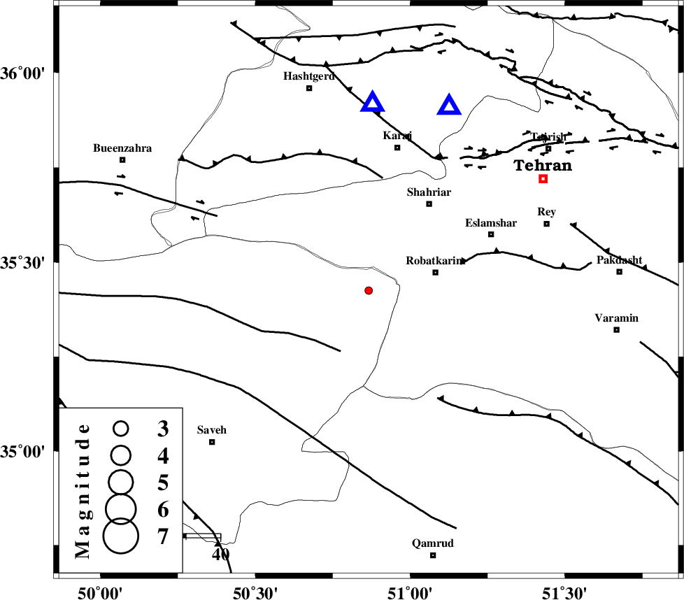
| Location | Lat:35.425 Lon: 50.866 |
| Region | Markazi Province, 20 km -West of Robatkarim |
Nearest Cities |
|
| 18 km North East of Rahimabad, Markazi Province | |
| 20 km West of Robatkarim, Tehran Province | |
| 22 km South West of Manjilabad, Tehran Province | |
| 25 km South West of Joqin, Tehran Province | |
| 28 km West of Vahnabad, Tehran Province | |
| Depth | 17 km |
| Agency | |
Faults within 150 km: |
|
| S_PARANDAK_F (Length: 116 km) , Distance to epicenter: 20 km | |
| KAHRIZAK_F (Length: 44 km) , Distance to epicenter: 28 km | |
| ESHTEHARD_F (Length: 69 km) , Distance to epicenter: 33 km | |
| Number of Phases | 5 |
| RMS | 0.2 |
| Number of Stations | 3 |
| Error in Latitude | >6.1 km |
| Error in Longitude | 3.7 km |
| Error in Depth | 7.7 km |
Download waveform in seisan format
to download seisan software Click here
to access information about IIEES stations Click here
Amplitude | ||||||||
| UID | Agency | Station | Component | Amplitude | Period | Arrival Time | Proccessing Time | Signal Clip |
| 101635 | IIEES | GHVR | E | 16.7 | 0.28 | 2015-10-09 05:44:10 | 2015-10-11 12:59:00 | n |
| 101636 | IIEES | GHVR | N | 14.2 | 0.18 | 2015-10-09 05:44:10 | 2015-10-11 12:59:00 | n |
Phase | ||||||||||||
| Agency | Station | Component | Phase Type | Phase Quality | First Motion | Observed Arrival Time | Time Residual | Loc. Flag | Input Weight | Distance | Azimuth | |
| IIEES | GHVR | Z | Pg | E | 2015-10-09 05:43:55 | -0.29 | y | 110 | 162 | |||
| IIEES | GHVR | E | Sg | E | 2015-10-09 05:44:09 | 0.17 | y | 110 | 162 | |||
| IIEES | ASAO | Z | Pg | E | 2015-10-09 05:43:58 | 0.29 | y | 124 | 219 | |||
| IIEES | ASAO | E | Sg | E | 2015-10-09 05:44:13 | -0.17 | y | 124 | 219 | |||
| IIEES | KHMZ | Z | Pn | E | 2015-10-09 05:44:10 | 0 | y | 204 | 204 | |||