
Magnitude |
2.5 |
| Date & Time (UTC) | 2015-10-17 21:47:24.6 |
| Date & Time (Local) | 1394/7/26 01:17:24.6 |
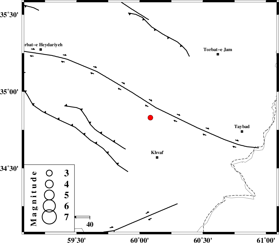
| Location | Lat:34.83 Lon: 60.084 |
| Region | Khorasan(center) Province, 29 km North of Khaf |
Nearest Cities |
|
| 14 km North East of Salami, Khorasan(center) Province | |
| 25 km North East of Chamanabad, Khorasan(center) Province | |
| 28 km South West of Bakhazar, Khorasan(center) Province | |
| 29 km North of Khaf, Khorasan(center) Province | |
| 30 km South of Ghalehno-e olia, Khorasan(center) Province | |
| Depth | 18 km |
| Agency | |
Faults within 150 km: |
|
| DORUNEH_F (Length: 713 km) , Distance to epicenter: 8 km | |
| KHAF_F (Length: 58 km) , Distance to epicenter: 29 km | |
| JANGAL_F (Length: 111 km) , Distance to epicenter: 40 km | |
| Number of Phases | 6 |
| RMS | 0.1 |
| Number of Stations | 5 |
| Error in Latitude | >2.3 km |
| Error in Longitude | 9 km |
| Error in Depth | 5.2 km |
Download waveform in seisan format
to download seisan software Click here
to access information about IIEES stations Click here
Amplitude | ||||||||
| UID | Agency | Station | Component | Amplitude | Period | Arrival Time | Proccessing Time | Signal Clip |
| 101817 | IIEES | SHRT | N | 121.2 | 0.31 | 2015-10-17 21:48:08 | 2015-10-18 07:24:00 | n |
| 101818 | IIEES | TABS | N | 17.8 | 0.45 | 2015-10-17 21:49:06 | 2015-10-18 07:24:00 | n |
| 101819 | IIEES | TABS | E | 10.4 | 0.36 | 2015-10-17 21:49:11 | 2015-10-18 07:24:00 | n |
| 101820 | IIEES | BSRN | E | 21 | 0.47 | 2015-10-17 21:49:11 | 2015-10-18 07:24:00 | n |
| 101821 | IIEES | BSRN | N | 21.5 | 0.52 | 2015-10-17 21:49:14 | 2015-10-18 07:24:00 | n |
Phase | ||||||||||||
| Agency | Station | Component | Phase Type | Phase Quality | First Motion | Observed Arrival Time | Time Residual | Loc. Flag | Input Weight | Distance | Azimuth | |
| IIEES | SHRT | Z | Pg | E | 2015-10-17 21:47:46 | 0.05 | y | 133 | 172 | |||
| IIEES | TABS | Z | Pn | E | 2015-10-17 21:48:09 | -0.06 | y | 303 | 245 | |||
| IIEES | BSRN | Z | Pn | E | 2015-10-17 21:48:12 | -0.16 | y | 330 | 196 | |||
| IIEES | BSRN | N | S | E | 2015-10-17 21:48:48 | 0.09 | y | 330 | 196 | |||
| IIEES | BJRD | Z | Pn | E | 2015-10-17 21:48:21 | -0.11 | y | 399 | 324 | |||
| IIEES | MRVT | Z | Pn | E | 2015-10-17 21:48:31 | 0.22 | y | 477 | 312 | |||