
Magnitude |
2.7 |
| Date & Time (UTC) | 2015-11-06 10:04:47.2 |
| Date & Time (Local) | 1394/8/15 13:34:47.2 |
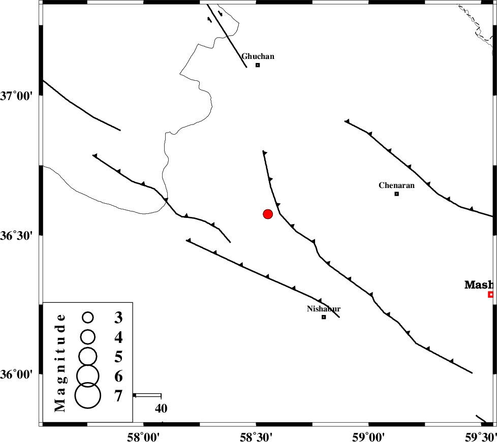
| Location | Lat:36.575 Lon: 58.552 |
| Region | Khorasan(center) Province, 59 km South of Quchan |
Nearest Cities |
|
| 5 km North of Kalateh mohammadkhan, Khorasan(center) Province | |
| 16 km South East of Abdollahgiv, Khorasan(center) Province | |
| 22 km North of Qalibaf, Khorasan(center) Province | |
| 30 km South of Chakaneh, Khorasan(center) Province | |
| 32 km North of Hemmatabad, Khorasan(center) Province | |
| Depth | 18 km |
| Agency | |
Faults within 150 km: |
|
| BINALUD_F1 (Length: 129 km) , Distance to epicenter: 5 km | |
| RIVAND_F (Length: 70 km) , Distance to epicenter: 19 km | |
| NAYSHABUR_F (Length: 74 km) , Distance to epicenter: 23 km | |
| Number of Phases | 6 |
| RMS | 0.1 |
| Number of Stations | 3 |
| Error in Latitude | >2.3 km |
| Error in Longitude | 4.8 km |
| Error in Depth | 5.5 km |
Download waveform in seisan format
to download seisan software Click here
to access information about IIEES stations Click here
Amplitude | ||||||||
| UID | Agency | Station | Component | Amplitude | Period | Arrival Time | Proccessing Time | Signal Clip |
| 102205 | IIEES | BJRD | E | 53.8 | 0.33 | 2015-11-06 10:05:38 | 2015-11-07 11:45:00 | n |
| 102206 | IIEES | BJRD | N | 178.8 | 0.24 | 2015-11-06 10:05:40 | 2015-11-07 11:45:00 | n |
Phase | ||||||||||||
| Agency | Station | Component | Phase Type | Phase Quality | First Motion | Observed Arrival Time | Time Residual | Loc. Flag | Input Weight | Distance | Azimuth | |
| IIEES | BJRD | Z | Pg | E | 2015-11-06 10:05:14 | 0.18 | y | 161 | 321 | |||
| IIEES | BJRD | N | Sg | E | 2015-11-06 10:05:33 | -0.02 | y | 161 | 321 | |||
| IIEES | SHRO | Z | Pn | E | 2015-11-06 10:05:23 | -0.16 | y | 237 | 255 | |||
| IIEES | SHRO | N | Sg | E | 2015-11-06 10:05:54 | 0.12 | y | 237 | 255 | |||
| IIEES | MRVT | Z | Pn | E | 2015-11-06 10:05:25 | -0.01 | y | 250 | 300 | |||
| IIEES | MRVT | N | Sg | E | 2015-11-06 10:05:57 | -0.11 | y | 250 | 300 | |||