
Magnitude |
2.6 |
| Date & Time (UTC) | 2016-05-24 18:27:40.3 |
| Date & Time (Local) | 1395/3/4 22:57:40.3 |
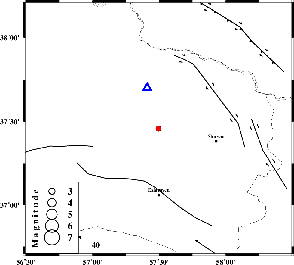
| Location | Lat:37.458 Lon: 57.495 |
| Region | Khorasan(north) Province, 14 km -East of Bojnurd |
Nearest Cities |
|
| 7 km of Hesar-egarmkhanh, Khorasan(north) Province | |
| 14 km East of Void, Khorasan(north) Province | |
| 14 km East of Bojnurd, Khorasan(north) Province | |
| 27 km North West of Zavarom, Khorasan(north) Province | |
| 32 km South West of Tukur, Khorasan(north) Province | |
| Depth | 14 km |
| Agency | |
Faults within 150 km: |
|
| ESFARAYEN_F (Length: 111 km) , Distance to epicenter: 36 km | |
| BAGHAN_GERMAB_F (Length: 79 km) , Distance to epicenter: 45 km | |
| ROBATE_QARABIL_F (Length: 168 km) , Distance to epicenter: 45 km | |
| Number of Phases | 7 |
| RMS | 0.2 |
| Number of Stations | 6 |
| Error in Latitude | >2.5 km |
| Error in Longitude | 4.6 km |
| Error in Depth | 5.8 km |
Download waveform in seisan format
to download seisan software Click here
to access information about IIEES stations Click here
Amplitude | ||||||||
| UID | Agency | Station | Component | Amplitude | Period | Arrival Time | Proccessing Time | Signal Clip |
| 106306 | IIEES | BJRD | E | 1258.6 | 0.34 | 2016-05-24 18:27:51 | 2016-05-25 05:23:00 | n |
| 106307 | IIEES | MRVT | N | 102.8 | 0.4 | 2016-05-24 18:28:22 | 2016-05-25 05:23:00 | n |
| 106308 | IIEES | MRVT | E | 142.9 | 0.24 | 2016-05-24 18:28:23 | 2016-05-25 05:23:00 | n |
Phase | ||||||||||||
| Agency | Station | Component | Phase Type | Phase Quality | First Motion | Observed Arrival Time | Time Residual | Loc. Flag | Input Weight | Distance | Azimuth | |
| IIEES | BJRD | Z | Pg | E | 2016-05-24 18:27:46 | 0.08 | y | 27.9 | 344 | |||
| IIEES | MRVT | Z | Pg | E | 2016-05-24 18:28:01 | -0.15 | y | 126 | 281 | |||
| IIEES | SHRO | Z | Pn | E | 2016-05-24 18:28:14 | 0.19 | y | 208 | 220 | |||
| IIEES | SHRO | N | Sg | E | 2016-05-24 18:28:39 | 0.02 | y | 208 | 220 | |||
| IIEES | TABS | Z | Pn | E | 2016-05-24 18:28:40 | 0.19 | y | 424 | 185 | |||
| IIEES | SHRT | Z | Pn | E | 2016-05-24 18:28:49 | -0.2 | y | 493 | 148 | |||
| IIEES | YZKH | Z | Pn | E | 2016-05-24 18:29:05 | -0.28 | y | 621 | 206 | |||