
Magnitude |
2.6 |
| Date & Time (UTC) | 2016-07-11 06:28:18.9 |
| Date & Time (Local) | 1395/4/21 10:58:18.9 |
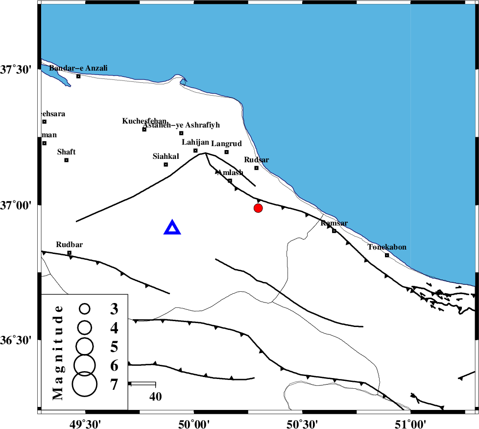
| Location | Lat:36.988 Lon: 50.296 |
| Region | Gilan Province, 17 km South of Rudsar |
Nearest Cities |
|
| 5 km of Rahimabad, Gilan Province | |
| 6 km of Kalachay, Gilan Province | |
| 8 km of Sanjus, Gilan Province | |
| 11 km West of Vajargah, Gilan Province | |
| 13 km North of Ziar, Gilan Province | |
| Depth | 23 km |
| Agency | |
Faults within 150 km: |
|
| KHAZAR_F (Length: 523 km) , Distance to epicenter: 5 km | |
| LAHIJAN_F (Length: 92 km) , Distance to epicenter: 9 km | |
| BONAN_F (Length: 74 km) , Distance to epicenter: 27 km | |
| Number of Phases | 9 |
| RMS | 0.2 |
| Number of Stations | 7 |
| Error in Latitude | >5.4 km |
| Error in Longitude | 3.2 km |
| Error in Depth | 3.4 km |
Download waveform in seisan format
to download seisan software Click here
to access information about IIEES stations Click here
Amplitude | ||||||||
| UID | Agency | Station | Component | Amplitude | Period | Arrival Time | Proccessing Time | Signal Clip |
| 107513 | IIEES | GIDE | N | 532.6 | 0.11 | 2016-07-11 06:28:32 | 2016-07-12 05:25:00 | n |
| 107514 | IIEES | ZNJK | N | 119 | 0.11 | 2016-07-11 06:29:02 | 2016-07-12 05:25:00 | n |
| 107515 | IIEES | ZNJK | E | 121 | 0.35 | 2016-07-11 06:29:04 | 2016-07-12 05:25:00 | n |
Phase | ||||||||||||
| Agency | Station | Component | Phase Type | Phase Quality | First Motion | Observed Arrival Time | Time Residual | Loc. Flag | Input Weight | Distance | Azimuth | |
| IIEES | GIDE | Z | Pg | E | 2016-07-11 06:28:26 | 0.23 | y | 35.1 | 258 | |||
| IIEES | CHTH | Z | Pg | E | 2016-07-11 06:28:42 | 0.03 | y | 141 | 148 | |||
| IIEES | CHTH | N | Sg | E | 2016-07-11 06:28:59 | -0.08 | y | 141 | 148 | |||
| IIEES | ZNJK | Z | Pg | E | 2016-07-11 06:28:43 | -0.15 | y | 148 | 257 | |||
| IIEES | ZNJK | N | Sg | E | 2016-07-11 06:29:00 | -0.16 | y | 148 | 257 | |||
| IIEES | DAMV | Z | Pn | E | 2016-07-11 06:28:52 | -0.33 | y | 213 | 135 | |||
| IIEES | ASAO | Z | Pn | E | 2016-07-11 06:28:59 | 0.07 | y | 272 | 185 | |||
| IIEES | GHVR | Z | Pn | E | 2016-07-11 06:29:02 | 0.36 | y | 291 | 163 | |||
| IIEES | SNGE | Z | Pn | E | 2016-07-11 06:29:08 | 0.07 | y | 339 | 233 | |||