
Magnitude |
2.2 |
| Date & Time (UTC) | 2016-07-30 04:31:57.6 |
| Date & Time (Local) | 1395/5/9 09:01:57.6 |
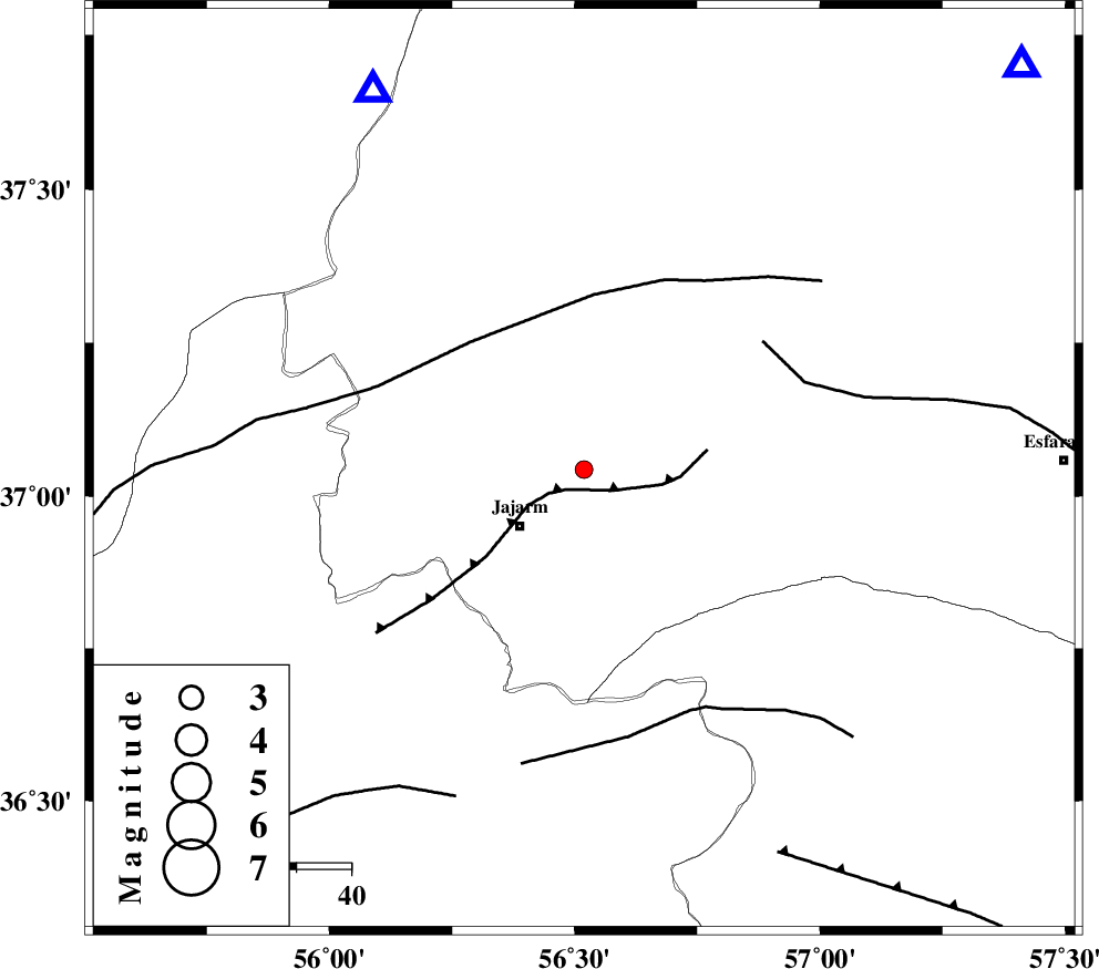
| Location | Lat:37.043 Lon: 56.519 |
| Region | Khorasan(north) Province, 15 km -East of Jajarm |
Nearest Cities |
|
| 15 km North East of Jajarm, Khorasan(north) Province | |
| 21 km North East of Garmeh, Khorasan(north) Province | |
| 38 km North West of Farashiyan, Khorasan(center) Province | |
| 44 km South West of Shogan, Khorasan(north) Province | |
| 60 km North West of Dasturan, Khorasan(center) Province | |
| Depth | 8 km |
| Agency | |
Faults within 150 km: |
|
| JAJARAM_F (Length: 77 km) , Distance to epicenter: 5 km | |
| ROBATE_QARABIL_F (Length: 168 km) , Distance to epicenter: 31 km | |
| ESFARAYEN_F (Length: 111 km) , Distance to epicenter: 40 km | |
| Number of Phases | 5 |
| RMS | 0.4 |
| Number of Stations | 5 |
| Error in Latitude | >4.3 km |
| Error in Longitude | 7.8 km |
| Error in Depth | 9.6 km |
Download waveform in seisan format
to download seisan software Click here
to access information about IIEES stations Click here
Amplitude | ||||||||
| UID | Agency | Station | Component | Amplitude | Period | Arrival Time | Proccessing Time | Signal Clip |
| 108051 | IIEES | MRVT | N | 76.7 | 0.4 | 2016-07-30 04:32:22 | 2016-07-31 06:37:00 | n |
| 108052 | IIEES | SHRO | N | 54.7 | 0.36 | 2016-07-30 04:32:39 | 2016-07-31 06:37:00 | n |
| 108053 | IIEES | SHRO | E | 40.8 | 0.18 | 2016-07-30 04:32:39 | 2016-07-31 06:37:00 | n |
| 108054 | IIEES | TABS | N | 7.1 | 0.56 | 2016-07-30 04:33:58 | 2016-07-31 06:37:00 | n |
Phase | ||||||||||||
| Agency | Station | Component | Phase Type | Phase Quality | First Motion | Observed Arrival Time | Time Residual | Loc. Flag | Input Weight | Distance | Azimuth | |
| IIEES | MRVT | Z | Pg | E | 2016-07-30 04:32:11 | 0.03 | y | 78.3 | 331 | |||
| IIEES | BJRD | Z | Pg | E | 2016-07-30 04:32:16 | -0.02 | y | 107 | 47 | |||
| IIEES | SHRO | Z | Pg | E | 2016-07-30 04:32:18 | -0.42 | y | 123 | 202 | |||
| IIEES | TABS | Z | Pn | E | 2016-07-30 04:32:54 | 0.82 | y | 380 | 172 | |||
| IIEES | SHRT | Z | Pn | E | 2016-07-30 04:33:08 | -0.4 | y | 509 | 137 | |||