
Magnitude |
2.5 |
| Date & Time (UTC) | 2016-08-14 04:28:57.3 |
| Date & Time (Local) | 1395/5/24 08:58:57.3 |
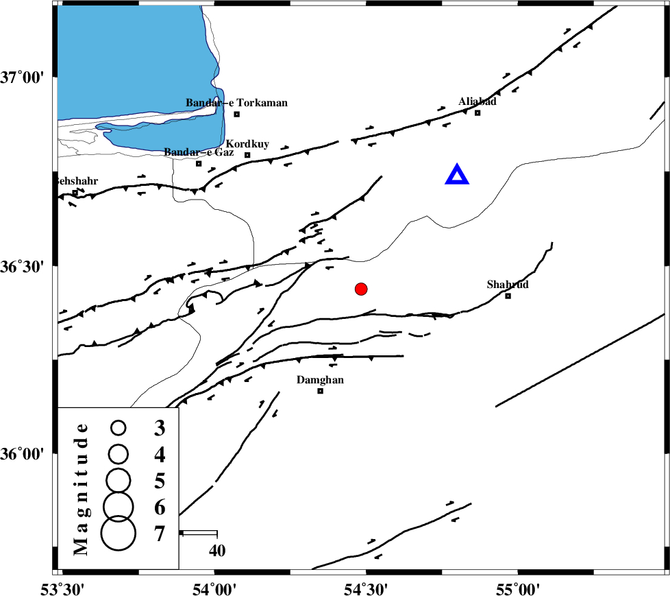
| Location | Lat:36.438 Lon: 54.483 |
| Region | Semnan Province, 33 km North-East of Damghan |
Nearest Cities |
|
| 13 km South of Cheharbagh, Golestan Province | |
| 15 km West of Majen, Semnan Province | |
| 25 km North of Mehmandust, Semnan Province | |
| 26 km South of Naharkhoran, Golestan Province | |
| 33 km North East of Damghan, Semnan Province | |
| Depth | 15 km |
| Agency | |
Faults within 150 km: |
|
| ASTANEH_F (Length: 72 km) , Distance to epicenter: 8 km | |
| SHAVAR_F (Length: 87 km) , Distance to epicenter: 16 km | |
| DAMGHAN_F (Length: 95 km) , Distance to epicenter: 19 km | |
| Number of Phases | 7 |
| RMS | 0.1 |
| Number of Stations | 6 |
| Error in Latitude | >3.3 km |
| Error in Longitude | 3.7 km |
| Error in Depth | 8.6 km |
Download waveform in seisan format
to download seisan software Click here
to access information about IIEES stations Click here
Amplitude | ||||||||
| UID | Agency | Station | Component | Amplitude | Period | Arrival Time | Proccessing Time | Signal Clip |
| 108541 | IIEES | DAMV | E | 24.6 | 0.61 | 2016-08-14 04:30:08 | 2016-08-14 06:38:00 | n |
| 108542 | IIEES | DAMV | N | 16.6 | 0.5 | 2016-08-14 04:30:13 | 2016-08-14 06:38:00 | n |
| 108543 | IIEES | TABS | N | 4.9 | 0.54 | 2016-08-14 04:30:55 | 2016-08-14 06:38:00 | n |
| 108544 | IIEES | GIDE | N | 10.9 | 0.18 | 2016-08-14 04:30:36 | 2016-08-14 06:38:00 | n |
| 108545 | IIEES | GIDE | E | 10.7 | 0.42 | 2016-08-14 04:30:36 | 2016-08-14 06:38:00 | n |
Phase | ||||||||||||
| Agency | Station | Component | Phase Type | Phase Quality | First Motion | Observed Arrival Time | Time Residual | Loc. Flag | Input Weight | Distance | Azimuth | |
| IIEES | SHRO | Z | Pg | E | 2016-08-14 04:29:21 | 0.11 | y | 146 | 109 | |||
| IIEES | SHRO | E | Sg | E | 2016-08-14 04:29:39 | -0.05 | y | 146 | 109 | |||
| IIEES | MRVT | Z | Pg | E | 2016-08-14 04:29:29 | -0.06 | y | 197 | 46 | |||
| IIEES | DAMV | Z | Pn | E | 2016-08-14 04:29:35 | -0.08 | y | 244 | 249 | |||
| IIEES | CHTH | Z | Pn | E | 2016-08-14 04:29:43 | -0.13 | y | 308 | 260 | |||
| IIEES | TABS | Z | Pn | E | 2016-08-14 04:29:53 | 0.02 | y | 392 | 141 | |||
| IIEES | GIDE | Z | Pn | E | 2016-08-14 04:29:56 | 0.23 | y | 412 | 279 | |||