
Magnitude |
2.6 |
| Date & Time (UTC) | 2016-10-04 13:16:18.5 |
| Date & Time (Local) | 1395/7/13 16:46:18.5 |
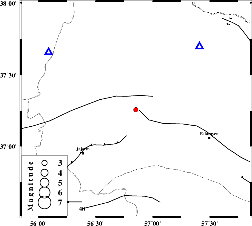
| Location | Lat:37.258 Lon: 56.853 |
| Region | Khorasan(north) Province, 33 km South of Ashkhaneh |
Nearest Cities |
|
| 10 km of Shogan, Khorasan(north) Province | |
| 33 km South of Ashkhaneh, Khorasan(north) Province | |
| 34 km North West of Cheharborj, Khorasan(north) Province | |
| 45 km North West of Zarqabad, Khorasan(north) Province | |
| 46 km South West of Pish qaleh, Khorasan(north) Province | |
| Depth | 15 km |
| Agency | |
Faults within 150 km: |
|
| ESFARAYEN_F (Length: 111 km) , Distance to epicenter: 3 km | |
| ROBATE_QARABIL_F (Length: 168 km) , Distance to epicenter: 12 km | |
| JAJARAM_F (Length: 77 km) , Distance to epicenter: 22 km | |
| Number of Phases | 5 |
| RMS | 0.2 |
| Number of Stations | 5 |
| Error in Latitude | >3.6 km |
| Error in Longitude | 4.7 km |
| Error in Depth | 9 km |
Download waveform in seisan format
to download seisan software Click here
to access information about IIEES stations Click here
Amplitude | ||||||||
| UID | Agency | Station | Component | Amplitude | Period | Arrival Time | Proccessing Time | Signal Clip |
| 109706 | IIEES | SHRO | E | 107.2 | 0.56 | 2016-10-04 13:17:09 | 2016-10-05 06:59:00 | n |
| 109707 | IIEES | TABS | N | 8.8 | 0.55 | 2016-10-04 13:18:22 | 2016-10-05 06:59:00 | n |
| 109708 | IIEES | TABS | E | 5.5 | 0.76 | 2016-10-04 13:18:24 | 2016-10-05 06:59:00 | n |
Phase | ||||||||||||
| Agency | Station | Component | Phase Type | Phase Quality | First Motion | Observed Arrival Time | Time Residual | Loc. Flag | Input Weight | Distance | Azimuth | |
| IIEES | BJRD | Z | Pg | E | 2016-10-04 13:16:30 | -0.18 | y | 69.4 | 45 | |||
| IIEES | MRVT | Z | Pg | E | 2016-10-04 13:16:32 | 0.16 | y | 80.9 | 304 | |||
| IIEES | SHRO | Z | Pg | E | 2016-10-04 13:16:44 | -0.34 | y | 158 | 209 | |||
| IIEES | TABS | Z | Pn | E | 2016-10-04 13:17:16 | 0.28 | y | 401 | 176 | |||
| IIEES | SHRT | Z | Pn | E | 2016-10-04 13:17:29 | 0.23 | y | 508 | 141 | |||