
Magnitude |
2.8 |
| Date & Time (UTC) | 2016-12-12 08:05:14.9 |
| Date & Time (Local) | 1395/9/22 11:35:14.9 |
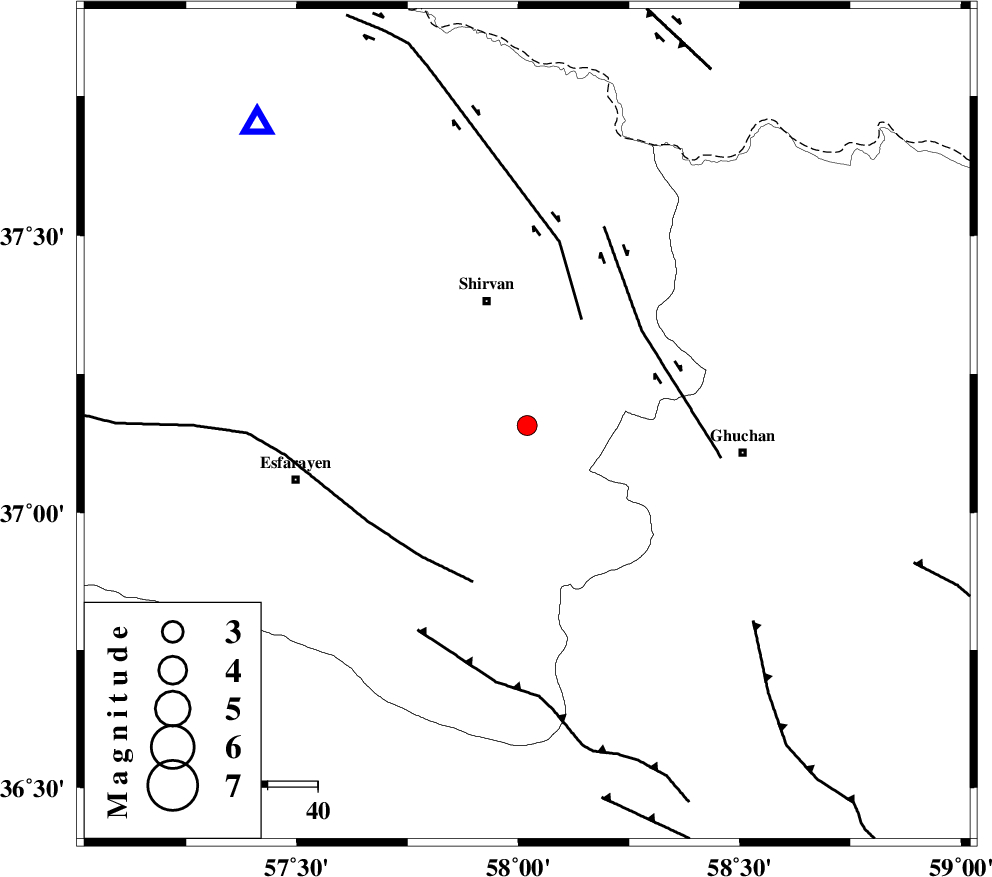
| Location | Lat:37.157 Lon: 58.02 |
| Region | Khorasan(center) Province, 26 km South of Shirvan |
Nearest Cities |
|
| 6 km of Maviyan, Khorasan(center) Province | |
| 13 km West of Chari, Khorasan(center) Province | |
| 13 km East of Geliyan, Khorasan(north) Province | |
| 19 km West of Faruj, Khorasan(center) Province | |
| 25 km South of Amirabad, Khorasan(north) Province | |
| Depth | 14 km |
| Agency | |
Faults within 150 km: |
|
| BAGHAN_GERMAB_F (Length: 79 km) , Distance to epicenter: 24 km | |
| GHUCHAN_F (Length: 50 km) , Distance to epicenter: 30 km | |
| ESFARAYEN_F (Length: 111 km) , Distance to epicenter: 33 km | |
| Number of Phases | 5 |
| RMS | 0.1 |
| Number of Stations | 4 |
| Error in Latitude | >4.4 km |
| Error in Longitude | 8.3 km |
| Error in Depth | 9 km |
Download waveform in seisan format
to download seisan software Click here
to access information about IIEES stations Click here
Amplitude | ||||||||
| UID | Agency | Station | Component | Amplitude | Period | Arrival Time | Proccessing Time | Signal Clip |
| 111315 | IIEES | BJRD | E | 533.2 | 0.2 | 2016-12-12 08:05:40 | 2016-12-12 08:45:00 | n |
| 111316 | IIEES | BJRD | N | 539.8 | 0.28 | 2016-12-12 08:05:40 | 2016-12-12 08:45:00 | n |
| 111317 | IIEES | MRVT | E | 72.6 | 0.21 | 2016-12-12 08:06:13 | 2016-12-12 08:45:00 | n |
| 111318 | IIEES | MRVT | N | 58.4 | 0.26 | 2016-12-12 08:06:13 | 2016-12-12 08:45:00 | n |
Phase | ||||||||||||
| Agency | Station | Component | Phase Type | Phase Quality | First Motion | Observed Arrival Time | Time Residual | Loc. Flag | Input Weight | Distance | Azimuth | |
| IIEES | BJRD | Z | Pg | E | 2016-12-12 08:05:28 | -0.11 | y | 81 | 318 | |||
| IIEES | BJRD | N | Sg | E | 2016-12-12 08:05:39 | 0.17 | y | 81 | 318 | |||
| IIEES | MRVT | Z | Pg | E | 2016-12-12 08:05:44 | -0.13 | y | 180 | 289 | |||
| IIEES | SHRO | Z | Pn | E | 2016-12-12 08:05:50 | 0 | y | 220 | 235 | |||
| IIEES | TABS | Z | Pn | E | 2016-12-12 08:06:12 | 0.08 | y | 398 | 192 | |||