
Magnitude |
2.8 |
| Date & Time (UTC) | 2017-02-25 10:34:21.3 |
| Date & Time (Local) | 1395/12/7 14:04:21.3 |
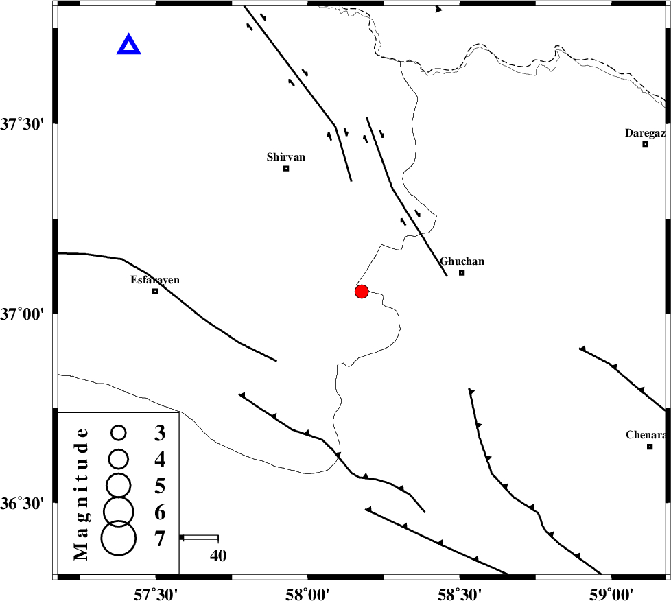
| Location | Lat:37.058 Lon: 58.177 |
| Region | Khorasan(center) Province, 30 km -West of Quchan |
Nearest Cities |
|
| 11 km South of Chari, Khorasan(center) Province | |
| 13 km North West of Yangi qaleh, Khorasan(center) Province | |
| 18 km South of Faruj, Khorasan(center) Province | |
| 20 km South East of Maviyan, Khorasan(center) Province | |
| 21 km West of Shahr-e kohneh, Khorasan(center) Province | |
| Depth | 18 km |
| Agency | |
Faults within 150 km: |
|
| GHUCHAN_F (Length: 50 km) , Distance to epicenter: 25 km | |
| ESFARAYEN_F (Length: 111 km) , Distance to epicenter: 32 km | |
| BAGHAN_GERMAB_F (Length: 79 km) , Distance to epicenter: 32 km | |
| Number of Phases | 6 |
| RMS | 0.1 |
| Number of Stations | 4 |
| Error in Latitude | >4.3 km |
| Error in Longitude | 3.2 km |
| Error in Depth | 8.8 km |
Download waveform in seisan format
to download seisan software Click here
to access information about IIEES stations Click here
Amplitude | ||||||||
| UID | Agency | Station | Component | Amplitude | Period | Arrival Time | Proccessing Time | Signal Clip |
| 113579 | IIEES | BJRD | E | 422.1 | 0.4 | 2017-02-25 10:34:52 | 2017-02-25 11:50:00 | n |
| 113580 | IIEES | BJRD | N | 313.4 | 0.3 | 2017-02-25 10:34:52 | 2017-02-25 11:50:00 | n |
| 113581 | IIEES | MRVT | E | 43.1 | 0.29 | 2017-02-25 10:35:20 | 2017-02-25 11:50:00 | n |
Phase | ||||||||||||
| Agency | Station | Component | Phase Type | Phase Quality | First Motion | Observed Arrival Time | Time Residual | Loc. Flag | Input Weight | Distance | Azimuth | |
| IIEES | BJRD | Z | Pg | E | 2017-02-25 10:34:38 | -0.01 | y | 98.5 | 317 | |||
| IIEES | BJRD | N | Sg | E | 2017-02-25 10:34:50 | -0.03 | y | 98.5 | 317 | |||
| IIEES | MRVT | Z | Pg | E | 2017-02-25 10:34:53 | -0.09 | y | 197 | 290 | |||
| IIEES | MRVT | N | Sg | E | 2017-02-25 10:35:17 | 0.16 | y | 197 | 290 | |||
| IIEES | SHRO | Z | Pn | E | 2017-02-25 10:34:56 | -0.13 | y | 226 | 240 | |||
| IIEES | SHRT | Z | Pn | E | 2017-02-25 10:35:21 | 0.14 | y | 424 | 152 | |||