
Magnitude |
3.6 |
| Date & Time (UTC) | 2017-04-12 17:12:03.2 |
| Date & Time (Local) | 1396/1/23 21:42:03.2 |
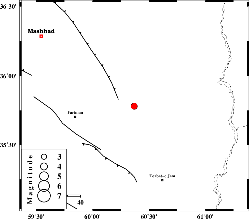
| Location | Lat:35.781 Lon: 60.369 |
| Region | Khorasan(center) Province, 48 km -East of Fariman |
Nearest Cities |
|
| 21 km South East of Kalateh menar, Khorasan(center) Province | |
| 30 km North East of Sefidsang, Khorasan(center) Province | |
| 30 km North West of Musaabad, Khorasan(center) Province | |
| 41 km North of Nasrabad, Khorasan(center) Province | |
| 42 km North East of Galandarabad, Khorasan(center) Province | |
| Depth | 15 km |
| Agency | |
Faults within 150 km: |
|
| BINALUD_F1 (Length: 178 km) , Distance to epicenter: 14 km | |
| TORBAT_E_JAM_F1 (Length: 71 km) , Distance to epicenter: 44 km | |
| TORBAT_E_JAM_F2 (Length: 57 km) , Distance to epicenter: 46 km | |
| Number of Phases | 6 |
| RMS | 0.5 |
| Number of Stations | 6 |
| Error in Latitude | >9.7 km |
| Error in Longitude | 5.7 km |
| Error in Depth | 0 km |
Download waveform in seisan format
to download seisan software Click here
to access information about IIEES stations Click here
Amplitude | ||||||||
| UID | Agency | Station | Component | Amplitude | Period | Arrival Time | Proccessing Time | Signal Clip |
| 115427 | IIEES | SHRT | N | 289.7 | 0.49 | 2017-04-12 17:13:17 | 2017-04-26 09:22:00 | n |
| 115428 | IIEES | SHRT | E | 299.9 | 0.56 | 2017-04-12 17:13:23 | 2017-04-26 09:22:00 | n |
| 115429 | IIEES | TABS | N | 162.2 | 0.54 | 2017-04-12 17:14:01 | 2017-04-26 09:22:00 | n |
| 115430 | IIEES | TABS | E | 69.8 | 0.74 | 2017-04-12 17:14:01 | 2017-04-26 09:22:00 | n |
Phase | ||||||||||||
| Agency | Station | Component | Phase Type | Phase Quality | First Motion | Observed Arrival Time | Time Residual | Loc. Flag | Input Weight | Distance | Azimuth | |
| IIEES | SHRT | Z | Pn | E | 2017-04-12 17:12:39 | -0.31 | y | 237 | 182 | |||
| IIEES | TABS | Z | Pn | E | 2017-04-12 17:12:58 | 0.11 | y | 380 | 232 | |||
| IIEES | SHRO | Z | Pn | E | 2017-04-12 17:12:59 | -0.78 | y | 394 | 275 | |||
| IIEES | MRVT | Z | Pn | E | 2017-04-12 17:13:05 | 0.48 | y | 435 | 300 | |||
| IIEES | BSRN | Z | Pn | E | 2017-04-12 17:13:05 | 0.37 | y | 439 | 196 | |||
| IIEES | YZKH | Z | Pn | E | 2017-04-12 17:13:32 | 0.42 | y | 652 | 236 | |||