
Magnitude |
2.8 |
| Date & Time (UTC) | 2017-09-16 05:16:21.3 |
| Date & Time (Local) | 1396/6/25 09:46:21.3 |
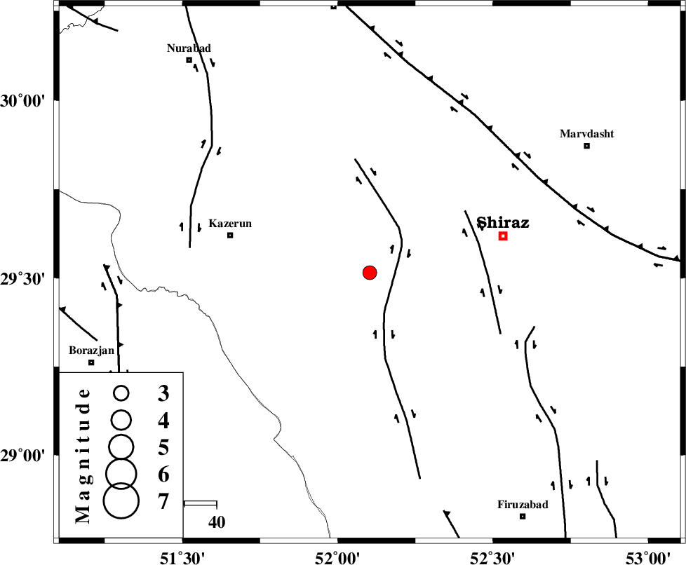
| Location | Lat:29.515 Lon: 52.103 |
| Region | Fars Province, 43 km South-West of Shiraz |
Nearest Cities |
|
| 6 km North of Richi, Fars Province | |
| 20 km South West of Khanehzanian, Fars Province | |
| 24 km East of Kalani, Fars Province | |
| 30 km North East of Baladeh, Fars Province | |
| 32 km North East of Dadin-e olia, Fars Province | |
| Depth | 14 km |
| Agency | |
Faults within 150 km: |
|
| KAREBASS_F (Length: 98 km) , Distance to epicenter: 9 km | |
| SABZ_PUSHAN_F_Z3 (Length: 37 km) , Distance to epicenter: 35 km | |
| SABZ_PUSHAN_F_Z1 (Length: 69 km) , Distance to epicenter: 53 km | |
| Number of Phases | 6 |
| RMS | 0.3 |
| Number of Stations | 4 |
| Error in Latitude | >3.7 km |
| Error in Longitude | 2.9 km |
| Error in Depth | 9.4 km |
Download waveform in seisan format
to download seisan software Click here
to access information about IIEES stations Click here
Amplitude | ||||||||
| UID | Agency | Station | Component | Amplitude | Period | Arrival Time | Proccessing Time | Signal Clip |
| 119562 | IIEES | AHRM | N | 293.1 | 0.29 | 2017-09-16 05:16:58 | 2017-09-16 10:48:00 | n |
| 119563 | IIEES | AHRM | E | 287.8 | 0.35 | 2017-09-16 05:16:59 | 2017-09-16 10:48:00 | n |
| 119564 | IIEES | GHIR | N | 157.7 | 0.32 | 2017-09-16 05:17:11 | 2017-09-16 10:48:00 | n |
| 119565 | IIEES | GHIR | E | 186.5 | 0.32 | 2017-09-16 05:17:15 | 2017-09-16 10:48:00 | n |
| 119566 | IIEES | KRBR | N | 7.7 | 0.49 | 2017-09-16 05:18:47 | 2017-09-16 10:48:00 | n |
| 119567 | IIEES | KRBR | E | 10.9 | 0.59 | 2017-09-16 05:18:48 | 2017-09-16 10:48:00 | n |
Phase | ||||||||||||
| Agency | Station | Component | Phase Type | Phase Quality | First Motion | Observed Arrival Time | Time Residual | Loc. Flag | Input Weight | Distance | Azimuth | |
| IIEES | AHRM | E | Pg | E | 2017-09-16 05:16:39 | -0.07 | y | 106 | 228 | |||
| IIEES | GHIR | Z | Pg | E | 2017-09-16 05:16:47 | -0.35 | y | 161 | 147 | |||
| IIEES | GHIR | N | Sg | E | 2017-09-16 05:17:07 | 0.32 | y | 161 | 147 | |||
| IIEES | YZKH | Z | Pn | E | 2017-09-16 05:17:18 | 0.3 | y | 398 | 36 | |||
| IIEES | KRBR | Z | Pn | E | 2017-09-16 05:17:25 | 0.06 | y | 453 | 82 | |||
| IIEES | KRBR | N | Sg | E | 2017-09-16 05:18:27 | -0.24 | y | 453 | 82 | |||