
Magnitude |
3.2 |
| Date & Time (UTC) | 2017-03-19 06:59:55.6 |
| Date & Time (Local) | 1395/12/29 10:29:55.6 |
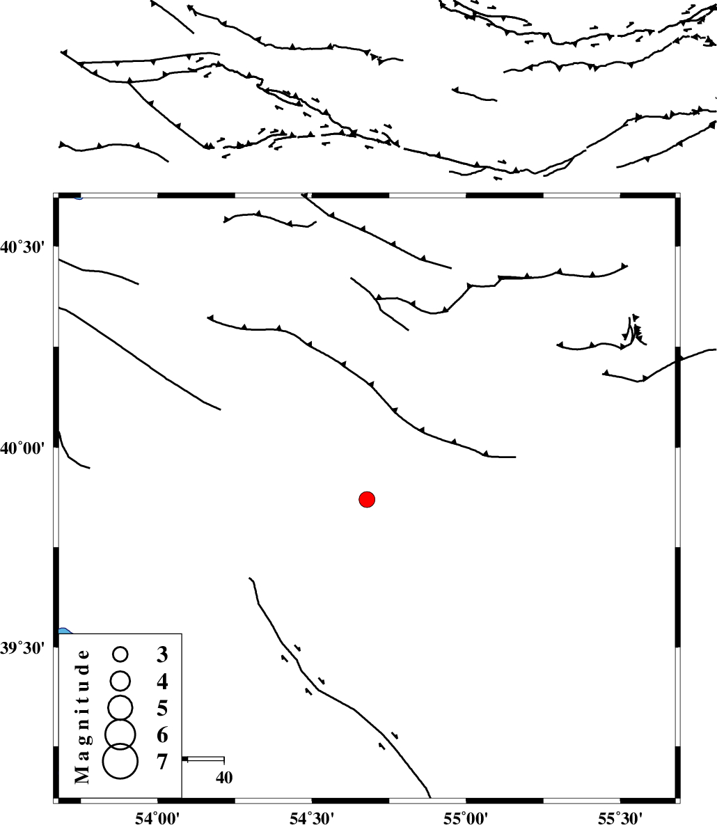
| Location | Lat:39.869 Lon: 54.678 |
| Region | Turkmenistan |
Nearest Cities |
|
| 147 km South East of Turkmenbasi, Turkmenistan Province | |
| 225 km North West of Karand, Golestan Province | |
| 243 km North West of Qareh aghaj, Golestan Province | |
| 245 km North West of Moravehtappeh, Golestan Province | |
| 250 km North West of Dashliborun, Golestan Province | |
| Depth | 16 km |
| Agency | |
Faults within 150 km: |
|
| MAIN_KOPEHDAGH_F1 (Length: 318 km) , Distance to epicenter: 44 km | |
| Number of Phases | 8 |
| RMS | 0.1 |
| Number of Stations | 8 |
| Error in Latitude | >9.1 km |
| Error in Longitude | 1.5 km |
| Error in Depth | 0 km |
Download waveform in seisan format
to download seisan software Click here
to access information about IIEES stations Click here
Amplitude | ||||||||
| UID | Agency | Station | Component | Amplitude | Period | Arrival Time | Proccessing Time | Signal Clip |
| 121126 | IIEES | DAMV | E | 9.4 | 0.28 | 2017-03-19 07:02:04 | 2017-11-07 08:03:00 | n |
| 121127 | IIEES | DAMV | N | 9.8 | 0.69 | 2017-03-19 07:02:04 | 2017-11-07 08:03:00 | n |
| 121128 | IIEES | THKV | E | 12.3 | 0.25 | 2017-03-19 07:02:07 | 2017-11-07 08:03:00 | n |
| 121129 | IIEES | THKV | N | 21.4 | 0.54 | 2017-03-19 07:02:07 | 2017-11-07 08:03:00 | n |
Phase | ||||||||||||
| Agency | Station | Component | Phase Type | Phase Quality | First Motion | Observed Arrival Time | Time Residual | Loc. Flag | Input Weight | Distance | Azimuth | |
| IIEES | MRVT | Z | Pn | E | 2017-03-19 07:00:37 | -0.04 | y | 274 | 153 | |||
| IIEES | BJRD | Z | P | E | 2017-03-19 07:00:45 | 0.06 | y | 338 | 135 | |||
| IIEES | SHRO | Z | Pn | E | 2017-03-19 07:00:58 | -0.16 | y | 444 | 164 | |||
| IIEES | DAMV | Z | Pn | E | 2017-03-19 07:01:09 | 0.14 | y | 527 | 208 | |||
| IIEES | CHTH | Z | Pn | E | 2017-03-19 07:01:10 | -0.16 | y | 539 | 217 | |||
| IIEES | THKV | Z | Pn | E | 2017-03-19 07:01:11 | 0.16 | y | 551 | 218 | |||
| IIEES | ZNJK | Z | Pn | E | 2017-03-19 07:01:21 | -0.09 | y | 633 | 238 | |||
| IIEES | TABS | Z | P | E | 2017-03-19 07:01:33 | 0.15 | y | 724 | 162 | |||