
Magnitude |
3 |
| Date & Time (UTC) | 2017-11-07 11:37:54.9 |
| Date & Time (Local) | 1396/8/16 15:07:54.9 |
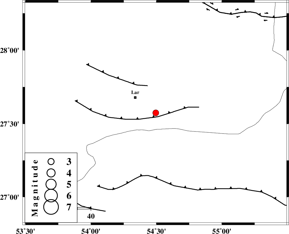
| Location | Lat:27.574 Lon: 54.495 |
| Region | Fars Province, 19 km South-East of Lar |
Nearest Cities |
|
| 18 km South East of Latifi, Fars Province | |
| 19 km South East of Lar, Fars Province | |
| 32 km South of Dehkuyeh, Fars Province | |
| 34 km East of Grash, Fars Province | |
| 44 km North East of Bastak, Hormozgan Province | |
| Depth | 14 km |
| Agency | |
Faults within 150 km: |
|
| LAR_F (Length: 99 km) , Distance to epicenter: 3 km | |
| BERIZ_F (Length: 49 km) , Distance to epicenter: 21 km | |
| MFF1 (Length: 180 km) , Distance to epicenter: 48 km | |
| Number of Phases | 5 |
| RMS | 0.1 |
| Number of Stations | 4 |
| Error in Latitude | >2.1 km |
| Error in Longitude | 1.5 km |
| Error in Depth | 3.5 km |
Download waveform in seisan format
to download seisan software Click here
to access information about IIEES stations Click here
Amplitude | ||||||||
| UID | Agency | Station | Component | Amplitude | Period | Arrival Time | Proccessing Time | Signal Clip |
| 121168 | IIEES | GHIR | E | 191 | 0.36 | 2017-11-07 11:38:57 | 2017-11-08 05:52:00 | n |
| 121169 | IIEES | GHIR | N | 236 | 0.28 | 2017-11-07 11:38:58 | 2017-11-08 05:52:00 | n |
| 121170 | IIEES | KRBR | E | 20.5 | 0.83 | 2017-11-07 11:39:57 | 2017-11-08 05:52:00 | n |
Phase | ||||||||||||
| Agency | Station | Component | Phase Type | Phase Quality | First Motion | Observed Arrival Time | Time Residual | Loc. Flag | Input Weight | Distance | Azimuth | |
| IIEES | BNDS | Z | Pg | E | 2017-11-07 11:38:22 | 0 | y | 167 | 96 | |||
| IIEES | GHIR | Z | Pg | E | 2017-11-07 11:38:22 | -0.05 | y | 168 | 298 | |||
| IIEES | KRBR | Z | Pn | E | 2017-11-07 11:38:45 | 0.01 | y | 347 | 39 | |||
| IIEES | KRBR | N | Sg | E | 2017-11-07 11:39:32 | -0.05 | y | 347 | 39 | |||
| IIEES | YZKH | Z | Pn | E | 2017-11-07 11:39:09 | 0.13 | y | 534 | 1 | |||