
Magnitude |
3 |
| Date & Time (UTC) | 2017-11-14 12:35:57.9 |
| Date & Time (Local) | 1396/8/23 16:05:57.9 |
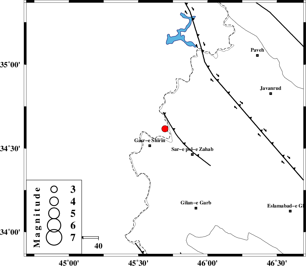
| Location | Lat:34.617 Lon: 45.692 |
| Region | Iraq, 15 km North-East of Qasr-E-Shirin |
Nearest Cities |
|
| 8 km North of Aqabarar, Kermanshah Province | |
| 9 km North of Mirmiru, Kermanshah Province | |
| 15 km West of Gardehnu, Kermanshah Province | |
| 15 km North East of Qasr-E-Shirin, Kermanshah Province | |
| 16 km South of Tappeh rash, Kermanshah Province | |
| Depth | 14 km |
| Agency | |
Faults within 150 km: |
|
| MFF8 (Length: 48 km) , Distance to epicenter: 5 km | |
| HZF4 (Length: 492 km) , Distance to epicenter: 47 km | |
| ZFF4 (Length: 128 km) , Distance to epicenter: 79 km | |
| Number of Phases | 8 |
| RMS | 0.2 |
| Number of Stations | 6 |
| Error in Latitude | >2.9 km |
| Error in Longitude | 6.7 km |
| Error in Depth | 7.8 km |
Download waveform in seisan format
to download seisan software Click here
to access information about IIEES stations Click here
Amplitude | ||||||||
| UID | Agency | Station | Component | Amplitude | Period | Arrival Time | Proccessing Time | Signal Clip |
| 122263 | IIEES | ILBA | N | 139.9 | 0.38 | 2017-11-14 12:36:39 | 2017-11-20 12:13:00 | n |
| 122264 | IIEES | SNGE | E | 197.8 | 0.54 | 2017-11-14 12:36:47 | 2017-11-20 12:13:00 | n |
| 122265 | IIEES | SNGE | N | 279.5 | 0.54 | 2017-11-14 12:36:48 | 2017-11-20 12:13:00 | n |
| 122266 | IIEES | GIDE | E | 15 | 0.35 | 2017-11-14 12:38:06 | 2017-11-20 12:13:00 | n |
| 122267 | IIEES | GIDE | N | 19.6 | 0.2 | 2017-11-14 12:38:12 | 2017-11-20 12:13:00 | n |
Phase | ||||||||||||
| Agency | Station | Component | Phase Type | Phase Quality | First Motion | Observed Arrival Time | Time Residual | Loc. Flag | Input Weight | Distance | Azimuth | |
| IIEES | ILBA | Z | Pg | E | 2017-11-14 12:36:17 | -0.2 | y | 120 | 156 | |||
| IIEES | ILBA | N | Sg | E | 2017-11-14 12:36:32 | 0.05 | y | 120 | 156 | |||
| IIEES | SNGE | Z | Pg | E | 2017-11-14 12:36:24 | -0.18 | y | 160 | 70 | |||
| IIEES | SNGE | N | Sg | E | 2017-11-14 12:36:43 | -0.07 | y | 160 | 70 | |||
| IIEES | ZNJK | Z | Pn | E | 2017-11-14 12:36:49 | 0.22 | y | 354 | 49 | |||
| IIEES | ASAO | Z | Pn | E | 2017-11-14 12:36:55 | 0.56 | y | 398 | 90 | |||
| IIEES | GIDE | Z | Pn | E | 2017-11-14 12:37:02 | -0.25 | y | 459 | 55 | |||
| IIEES | GRMI | Z | Pn | E | 2017-11-14 12:37:08 | -0.06 | y | 505 | 22 | |||