
Magnitude |
2.3 |
| Date & Time (UTC) | 2017-11-23 04:39:44.2 |
| Date & Time (Local) | 1396/9/2 08:09:44.2 |
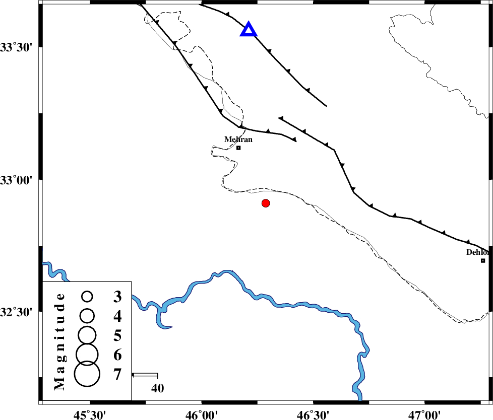
| Location | Lat:32.911 Lon: 46.287 |
| Region | Iraq, 26 km South-East of Mehran |
Nearest Cities |
|
| 26 km South East of Mehran, Ilam Province | |
| 45 km South West of Gonbad-e pirmohammad, Ilam Province | |
| 49 km South West of Galeh-yedarre-hemalakshahi, Ilam Province | |
| 61 km South West of Mehr, Ilam Province | |
| 63 km South of Salehabad, Ilam Province | |
| Depth | 18 km |
| Agency | |
Faults within 150 km: |
|
| ZFF4 (Length: 128 km) , Distance to epicenter: 29 km | |
| MFF6 (Length: 144 km) , Distance to epicenter: 35 km | |
| MFF7 (Length: 99 km) , Distance to epicenter: 48 km | |
| Number of Phases | 6 |
| RMS | 0 |
| Number of Stations | 5 |
| Error in Latitude | >4.1 km |
| Error in Longitude | 7.9 km |
| Error in Depth | 5.7 km |
Download waveform in seisan format
to download seisan software Click here
to access information about IIEES stations Click here
Amplitude | ||||||||
| UID | Agency | Station | Component | Amplitude | Period | Arrival Time | Proccessing Time | Signal Clip |
| 122513 | IIEES | ILBA | N | 117.1 | 0.65 | 2017-11-23 04:40:12 | 2017-11-25 10:49:00 | n |
| 122514 | IIEES | SNGE | E | 13.7 | 0.53 | 2017-11-23 04:41:00 | 2017-11-25 10:49:00 | n |
| 122515 | IIEES | SNGE | N | 14.2 | 0.46 | 2017-11-23 04:41:03 | 2017-11-25 10:49:00 | n |
| 122516 | IIEES | KHMZ | N | 6.3 | 0.48 | 2017-11-23 04:41:18 | 2017-11-25 10:49:00 | n |
| 122517 | IIEES | KHMZ | E | 6 | 0.36 | 2017-11-23 04:41:27 | 2017-11-25 10:49:00 | n |
| 122518 | IIEES | ASAO | E | 5.5 | 0.34 | 2017-11-23 04:41:27 | 2017-11-25 10:49:00 | n |
| 122519 | IIEES | ASAO | N | 4.1 | 0.77 | 2017-11-23 04:41:40 | 2017-11-25 10:49:00 | n |
Phase | ||||||||||||
| Agency | Station | Component | Phase Type | Phase Quality | First Motion | Observed Arrival Time | Time Residual | Loc. Flag | Input Weight | Distance | Azimuth | |
| IIEES | ILBA | Z | Pg | E | 2017-11-23 04:39:57 | 0.01 | y | 79.5 | 355 | |||
| IIEES | ILBA | N | Sg | E | 2017-11-23 04:40:08 | 0 | y | 79.5 | 355 | |||
| IIEES | SNGE | Z | Pn | E | 2017-11-23 04:40:24 | -0.01 | y | 261 | 22 | |||
| IIEES | KHMZ | Z | Pn | E | 2017-11-23 04:40:35 | -0.04 | y | 355 | 74 | |||
| IIEES | ASAO | Z | Pn | E | 2017-11-23 04:40:40 | 0.05 | y | 391 | 61 | |||
| IIEES | GHVR | Z | Pn | E | 2017-11-23 04:40:52 | 0 | y | 492 | 68 | |||