
Magnitude |
3 |
| Date & Time (UTC) | 2017-12-27 01:09:25.9 |
| Date & Time (Local) | 1396/10/6 04:39:25.9 |
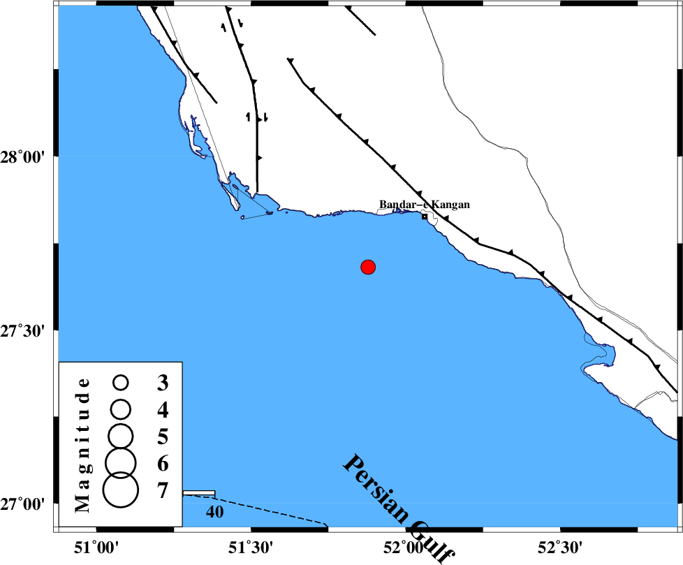
| Location | Lat:27.681 Lon: 51.878 |
| Region | Persian Gulf, 24 km South-West of Bandar-e kangan |
Nearest Cities |
|
| 24 km South West of Bandar-e kangan, Bushehr Province | |
| 45 km South West of Riz, Bushehr Province | |
| 46 km North West of Bandar-e taheri, Bushehr Province | |
| 46 km South East of Abdan, Bushehr Province | |
| 46 km South West of Jam, Bushehr Province | |
| Depth | 18 km |
| Agency | |
Faults within 150 km: |
|
| MFF3 (Length: 292 km) , Distance to epicenter: 28 km | |
| BORAZJAN_F (Length: 168 km) , Distance to epicenter: 43 km | |
| ZFF2 (Length: 84 km) , Distance to epicenter: 71 km | |
| Number of Phases | 8 |
| RMS | 0.3 |
| Number of Stations | 6 |
| Error in Latitude | >7.2 km |
| Error in Longitude | 3.5 km |
| Error in Depth | 7.1 km |
Download waveform in seisan format
to download seisan software Click here
to access information about IIEES stations Click here
Amplitude | ||||||||
| UID | Agency | Station | Component | Amplitude | Period | Arrival Time | Proccessing Time | Signal Clip |
| 125646 | IIEES | AHRM | N | 351.7 | 0.43 | 2017-12-27 01:10:13 | 2017-12-27 11:01:00 | n |
| 125647 | IIEES | AHRM | E | 214.1 | 0.51 | 2017-12-27 01:10:16 | 2017-12-27 11:01:00 | n |
| 125648 | IIEES | KRBR | E | 12.1 | 0.28 | 2017-12-27 01:12:42 | 2017-12-27 11:01:00 | n |
| 125649 | IIEES | YZKH | N | 4.2 | 0.56 | 2017-12-27 01:11:51 | 2017-12-27 11:01:00 | n |
| 125650 | IIEES | YZKH | E | 3.7 | 0.63 | 2017-12-27 01:11:51 | 2017-12-27 11:01:00 | n |
Phase | ||||||||||||
| Agency | Station | Component | Phase Type | Phase Quality | First Motion | Observed Arrival Time | Time Residual | Loc. Flag | Input Weight | Distance | Azimuth | |
| IIEES | GHIR | Z | Pg | E | 2017-12-27 01:09:47 | -0.12 | y | 128 | 58 | |||
| IIEES | GHIR | N | Sg | E | 2017-12-27 01:10:03 | -0.03 | y | 128 | 58 | |||
| IIEES | AHRM | Z | Pg | E | 2017-12-27 01:09:49 | 0.05 | y | 143 | 337 | |||
| IIEES | AHRM | N | Sg | E | 2017-12-27 01:10:07 | 0.11 | y | 143 | 337 | |||
| IIEES | KRBR | Z | Pn | E | 2017-12-27 01:10:41 | 0.62 | y | 540 | 61 | |||
| IIEES | YZKH | Z | Pn | E | 2017-12-27 01:10:45 | -0.33 | y | 584 | 26 | |||
| IIEES | TABS | Z | Pn | E | 2017-12-27 01:11:16 | -0.07 | y | 830 | 36 | |||
| IIEES | SNGE | Z | Pn | E | 2017-12-27 01:11:27 | -0.69 | y | 928 | 333 | |||