
Magnitude |
2.2 |
| Date & Time (UTC) | 2017-12-25 18:48:01.8 |
| Date & Time (Local) | 1396/10/4 22:18:01.8 |
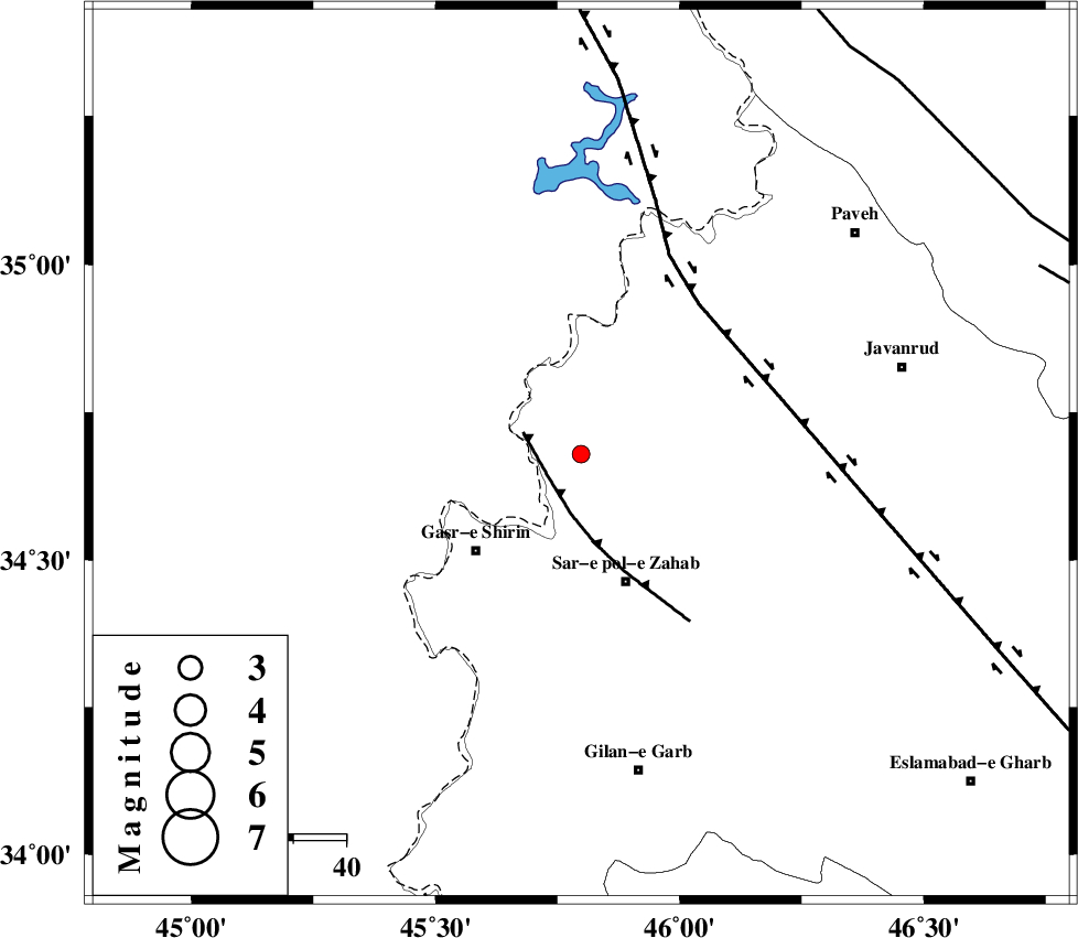
| Location | Lat:34.679 Lon: 45.798 |
| Region | Kermanshah Province, 10 km of Tazehabad |
Nearest Cities |
|
| 4 km of Gardehnu, Kermanshah Province | |
| 10 km of Tazehabad, Kermanshah Province | |
| 11 km of Tappeh rash, Kermanshah Province | |
| 12 km North West of Bazmirabad, Kermanshah Province | |
| 13 km North of Mirmiru, Kermanshah Province | |
| Depth | 18 km |
| Agency | |
Faults within 150 km: |
|
| MFF8 (Length: 48 km) , Distance to epicenter: 7 km | |
| HZF4 (Length: 492 km) , Distance to epicenter: 36 km | |
| ZFF4 (Length: 128 km) , Distance to epicenter: 88 km | |
| Number of Phases | 5 |
| RMS | 0 |
| Number of Stations | 3 |
| Error in Latitude | >2.2 km |
| Error in Longitude | 4.7 km |
| Error in Depth | 8.1 km |
Download waveform in seisan format
to download seisan software Click here
to access information about IIEES stations Click here
Amplitude | ||||||||
| UID | Agency | Station | Component | Amplitude | Period | Arrival Time | Proccessing Time | Signal Clip |
| 126348 | IIEES | ILBA | N | 71.1 | 0.58 | 2017-12-25 18:48:50 | 2018-01-07 09:29:00 | n |
| 126349 | IIEES | SNGE | N | 41.5 | 0.41 | 2017-12-25 18:48:52 | 2018-01-07 09:29:00 | n |
| 126350 | IIEES | SNGE | E | 30.5 | 0.53 | 2017-12-25 18:49:03 | 2018-01-07 09:29:00 | n |
| 126351 | IIEES | GRMI | E | 1.3 | 0.65 | 2017-12-25 18:50:32 | 2018-01-07 09:29:00 | n |
Phase | ||||||||||||
| Agency | Station | Component | Phase Type | Phase Quality | First Motion | Observed Arrival Time | Time Residual | Loc. Flag | Input Weight | Distance | Azimuth | |
| IIEES | ILBA | Z | Pg | E | 2017-12-25 18:48:22 | 0.06 | y | 123 | 162 | |||
| IIEES | ILBA | N | Sg | E | 2017-12-25 18:48:37 | -0.04 | y | 123 | 162 | |||
| IIEES | SNGE | Z | Pg | E | 2017-12-25 18:48:26 | -0.05 | y | 149 | 72 | |||
| IIEES | SNGE | N | Sg | E | 2017-12-25 18:48:44 | 0.03 | y | 149 | 72 | |||
| IIEES | GRMI | Z | Pn | E | 2017-12-25 18:49:10 | -0.01 | y | 495 | 22 | |||