
Magnitude |
2.3 |
| Date & Time (UTC) | 2018-01-13 15:35:55.0 |
| Date & Time (Local) | 1396/10/23 19:05:55.0 |
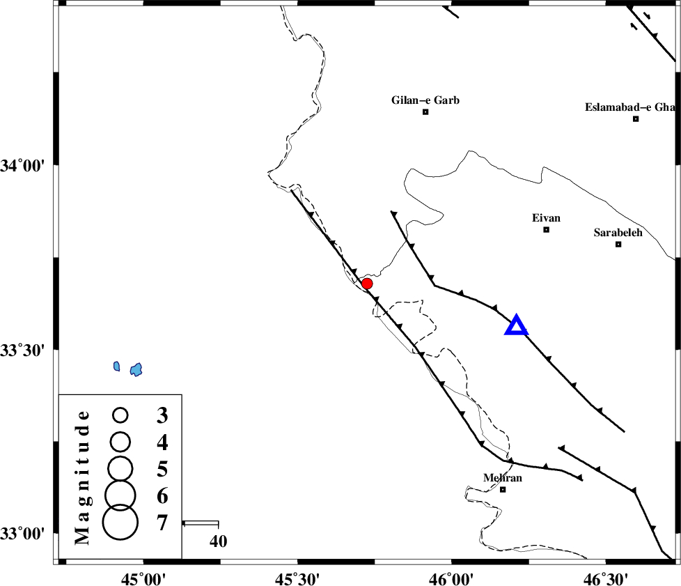
| Location | Lat:33.679 Lon: 45.725 |
| Region | Ilam Province, 54 km South-West of Gilan-E-Gharb |
Nearest Cities |
|
| 24 km South of Sumar, Kermanshah Province | |
| 45 km South West of Nian, Kermanshah Province | |
| 48 km South West of Teran, Ilam Province | |
| 49 km North West of Salehabad, Ilam Province | |
| 50 km West of Chavar, Ilam Province | |
| Depth | 14 km |
| Agency | |
Faults within 150 km: |
|
| ZFF4 (Length: 128 km) , Distance to epicenter: 2 km | |
| MFF7 (Length: 99 km) , Distance to epicenter: 18 km | |
| MFF6 (Length: 144 km) , Distance to epicenter: 76 km | |
| Number of Phases | 5 |
| RMS | 0.2 |
| Number of Stations | 3 |
| Error in Latitude | >3 km |
| Error in Longitude | 7.9 km |
| Error in Depth | 8.5 km |
Download waveform in seisan format
to download seisan software Click here
to access information about IIEES stations Click here
Amplitude | ||||||||
| UID | Agency | Station | Component | Amplitude | Period | Arrival Time | Proccessing Time | Signal Clip |
| 126773 | IIEES | SNGE | N | 31.7 | 0.33 | 2018-01-13 15:36:59 | 2018-01-14 07:36:00 | n |
| 126774 | IIEES | SNGE | E | 19.4 | 0.47 | 2018-01-13 15:37:05 | 2018-01-14 07:36:00 | n |
| 126775 | IIEES | ASAO | N | 3.3 | 0.47 | 2018-01-13 15:37:41 | 2018-01-14 07:36:00 | n |
Phase | ||||||||||||
| Agency | Station | Component | Phase Type | Phase Quality | First Motion | Observed Arrival Time | Time Residual | Loc. Flag | Input Weight | Distance | Azimuth | |
| IIEES | ILBA | Z | Pg | E | 2018-01-13 15:36:03 | -0.26 | y | 45.2 | 98 | |||
| IIEES | ILBA | N | Sg | E | 2018-01-13 15:36:09 | 0.16 | y | 45.2 | 98 | |||
| IIEES | SNGE | Z | Pn | E | 2018-01-13 15:36:30 | 0.23 | y | 216 | 43 | |||
| IIEES | SNGE | N | Sg | E | 2018-01-13 15:36:56 | -0.1 | y | 216 | 43 | |||
| IIEES | ASAO | Z | Pn | E | 2018-01-13 15:36:53 | -0.03 | y | 408 | 75 | |||