
Magnitude |
2.7 |
| Date & Time (UTC) | 2018-02-28 00:18:58.6 |
| Date & Time (Local) | 1396/12/9 03:48:58.6 |
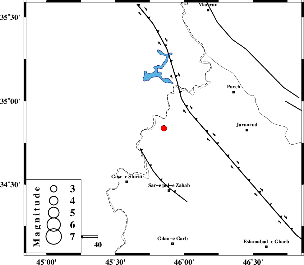
| Location | Lat:34.837 Lon: 45.852 |
| Region | Kermanshah Province, 8 km of Tazehabad |
Nearest Cities |
|
| 8 km North of Tazehabad, Kermanshah Province | |
| 11 km West of Dehsheykh, Kermanshah Province | |
| 15 km North of Gardehnu, Kermanshah Province | |
| 15 km North East of Tappeh rash, Kermanshah Province | |
| 24 km North of Bazmirabad, Kermanshah Province | |
| Depth | 14 km |
| Agency | |
Faults within 150 km: |
|
| HZF4 (Length: 492 km) , Distance to epicenter: 20 km | |
| MFF8 (Length: 48 km) , Distance to epicenter: 21 km | |
| PIRANSHAHR_F (Length: 253 km) , Distance to epicenter: 74 km | |
| Number of Phases | 7 |
| RMS | 0.2 |
| Number of Stations | 6 |
| Error in Latitude | >2 km |
| Error in Longitude | 2.4 km |
| Error in Depth | 3.9 km |
Download waveform in seisan format
to download seisan software Click here
to access information about IIEES stations Click here
Amplitude | ||||||||
| UID | Agency | Station | Component | Amplitude | Period | Arrival Time | Proccessing Time | Signal Clip |
| 129068 | IIEES | SNGE | N | 148.5 | 0.81 | 2018-02-28 00:19:44 | 2018-02-28 07:24:00 | n |
| 129069 | IIEES | SNGE | E | 104.2 | 0.67 | 2018-02-28 00:19:44 | 2018-02-28 07:24:00 | n |
| 129070 | IIEES | SRSL | E | 111.8 | 0.36 | 2018-02-28 00:19:50 | 2018-02-28 07:24:00 | n |
| 129071 | IIEES | SRSL | N | 100.3 | 0.53 | 2018-02-28 00:19:52 | 2018-02-28 07:24:00 | n |
Phase | ||||||||||||
| Agency | Station | Component | Phase Type | Phase Quality | First Motion | Observed Arrival Time | Time Residual | Loc. Flag | Input Weight | Distance | Azimuth | |
| IIEES | ILBA | Z | Pg | E | 2018-02-28 00:19:21 | -0.02 | y | 138 | 166 | |||
| IIEES | SNGE | Z | Pg | E | 2018-02-28 00:19:21 | 0.05 | y | 139 | 78 | |||
| IIEES | SNGE | N | Sg | E | 2018-02-28 00:19:38 | -0.1 | y | 139 | 78 | |||
| IIEES | SRSL | Z | Pg | E | 2018-02-28 00:19:24 | -0.08 | y | 157 | 346 | |||
| IIEES | ZNJK | Z | Pn | E | 2018-02-28 00:19:47 | 0.36 | y | 327 | 51 | |||
| IIEES | ASAO | Z | Pn | E | 2018-02-28 00:19:54 | -0.06 | y | 384 | 94 | |||
| IIEES | GRMI | Z | Pn | E | 2018-02-28 00:20:05 | -0.18 | y | 477 | 22 | |||