
Magnitude |
2.3 |
| Date & Time (UTC) | 2018-04-01 13:59:55.2 |
| Date & Time (Local) | 1397/1/12 18:29:55.2 |
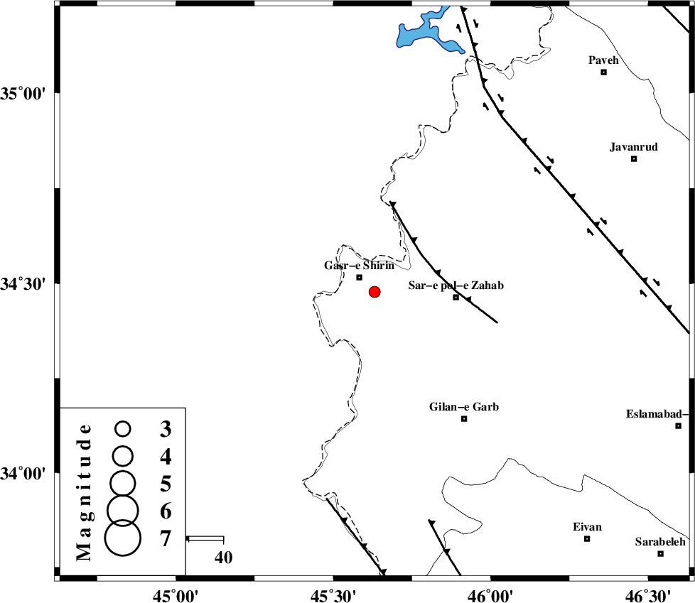
| Location | Lat:34.477 Lon: 45.631 |
| Region | Kermanshah Province, 6 km of Qasr-E-Shirin |
Nearest Cities |
|
| 5 km North of Seyyed sohrab, Kermanshah Province | |
| 6 km of Qasr-E-Shirin, Kermanshah Province | |
| 8 km of Aqabarar, Kermanshah Province | |
| 14 km West of Qareh belagh, Kermanshah Province | |
| 16 km West of Mirmiru, Kermanshah Province | |
| Depth | 16 km |
| Agency | |
Faults within 150 km: |
|
| MFF8 (Length: 48 km) , Distance to epicenter: 17 km | |
| ZFF4 (Length: 128 km) , Distance to epicenter: 62 km | |
| HZF4 (Length: 492 km) , Distance to epicenter: 63 km | |
| Number of Phases | 5 |
| RMS | 0.1 |
| Number of Stations | 4 |
| Error in Latitude | >1.7 km |
| Error in Longitude | 8.7 km |
| Error in Depth | 3.7 km |
Download waveform in seisan format
to download seisan software Click here
to access information about IIEES stations Click here
Amplitude | ||||||||
| UID | Agency | Station | Component | Amplitude | Period | Arrival Time | Proccessing Time | Signal Clip |
| 133106 | IIEES | ILBA | N | 70.7 | 0.29 | 2018-04-01 14:00:32 | 2018-06-03 11:40:00 | n |
| 133107 | IIEES | ILBA | E | 90 | 0.41 | 2018-04-01 14:00:33 | 2018-06-03 11:40:00 | n |
Phase | ||||||||||||
| Agency | Station | Component | Phase Type | Phase Quality | First Motion | Observed Arrival Time | Time Residual | Loc. Flag | Input Weight | Distance | Azimuth | |
| IIEES | ILBA | Z | Pg | E | 2018-04-01 14:00:13 | 0 | y | 109 | 150 | |||
| IIEES | ILBA | N | Sg | E | 2018-04-01 14:00:26 | 0.01 | y | 109 | 150 | |||
| IIEES | SNGE | Z | Pg | E | 2018-04-01 14:00:23 | -0.01 | y | 171 | 66 | |||
| IIEES | ASAO | Z | Pn | E | 2018-04-01 14:00:53 | 0.11 | y | 404 | 88 | |||
| IIEES | KHMZ | Z | Pn | E | 2018-04-01 14:00:53 | -0.11 | y | 408 | 100 | |||