
Magnitude |
4 |
| Date & Time (UTC) | 2018-07-21 06:15:15.5 |
| Date & Time (Local) | 1397/4/30 10:45:15.5 |
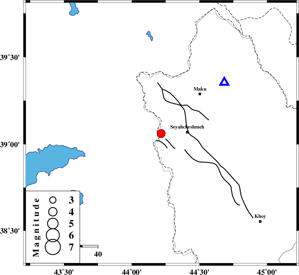
| Location | Lat:39.061 Lon: 44.217 |
| Region | Azarbaijan Gharbi Province, 17 km -West of Seyah Cheshmah |
Nearest Cities |
|
| 3 km North of Sheykh selu-e paein, Azarbaijan Gharbi Province | |
| 4 km of Sheykh selu-e bala, Azarbaijan Gharbi Province | |
| 15 km West of Zavieh, Azarbaijan Gharbi Province | |
| 17 km West of Seyah Cheshmah, Azarbaijan Gharbi Province | |
| 28 km South of Arab dizaj, Azarbaijan Gharbi Province | |
| Depth | 14 km |
| Agency | |
Faults within 150 km: |
|
| KHOY (Length: 100 km) , Distance to epicenter: 4 km | |
| SALMAS (Length: 20 km) , Distance to epicenter: 98 km | |
| N_TABRIZ_F3 (Length: 66 km) , Distance to epicenter: 102 km | |
| Number of Phases | 8 |
| RMS | 0.2 |
| Number of Stations | 6 |
| Error in Latitude | >3.6 km |
| Error in Longitude | 5.8 km |
| Error in Depth | 9.6 km |
Download waveform in seisan format
to download seisan software Click here
to access information about IIEES stations Click here
Amplitude | ||||||||
| UID | Agency | Station | Component | Amplitude | Period | Arrival Time | Proccessing Time | Signal Clip |
| 134896 | IIEES | MAKU | E | 11679.6 | 0.26 | 2018-07-21 06:15:34 | 2018-07-21 08:02:00 | n |
Phase | ||||||||||||
| Agency | Station | Component | Phase Type | Phase Quality | First Motion | Observed Arrival Time | Time Residual | Loc. Flag | Input Weight | Distance | Azimuth | |
| IIEES | MAKU | Z | Pg | E | 2018-07-21 06:15:24 | -0.22 | y | 51.9 | 51 | |||
| IIEES | MAKU | N | Sg | E | 2018-07-21 06:15:31 | 0.04 | y | 51.9 | 51 | |||
| IIEES | GRMI | Z | Pn | E | 2018-07-21 06:16:03 | 0.49 | y | 320 | 94 | |||
| IIEES | GRMI | N | Sg | E | 2018-07-21 06:16:45 | -0.11 | y | 320 | 94 | |||
| IIEES | SRSL | Z | Pn | E | 2018-07-21 06:16:04 | -0.13 | y | 334 | 161 | |||
| IIEES | ZNJK | Z | Pn | E | 2018-07-21 06:16:22 | -0.08 | y | 474 | 123 | |||
| IIEES | SNGE | Z | Pn | E | 2018-07-21 06:16:28 | 0.03 | y | 521 | 147 | |||
| IIEES | ILBA | Z | Pn | E | 2018-07-21 06:16:41 | -0.03 | y | 629 | 163 | |||