
Magnitude |
2.9 |
| Date & Time (UTC) | 2018-07-28 01:53:48.6 |
| Date & Time (Local) | 1397/5/6 06:23:48.6 |
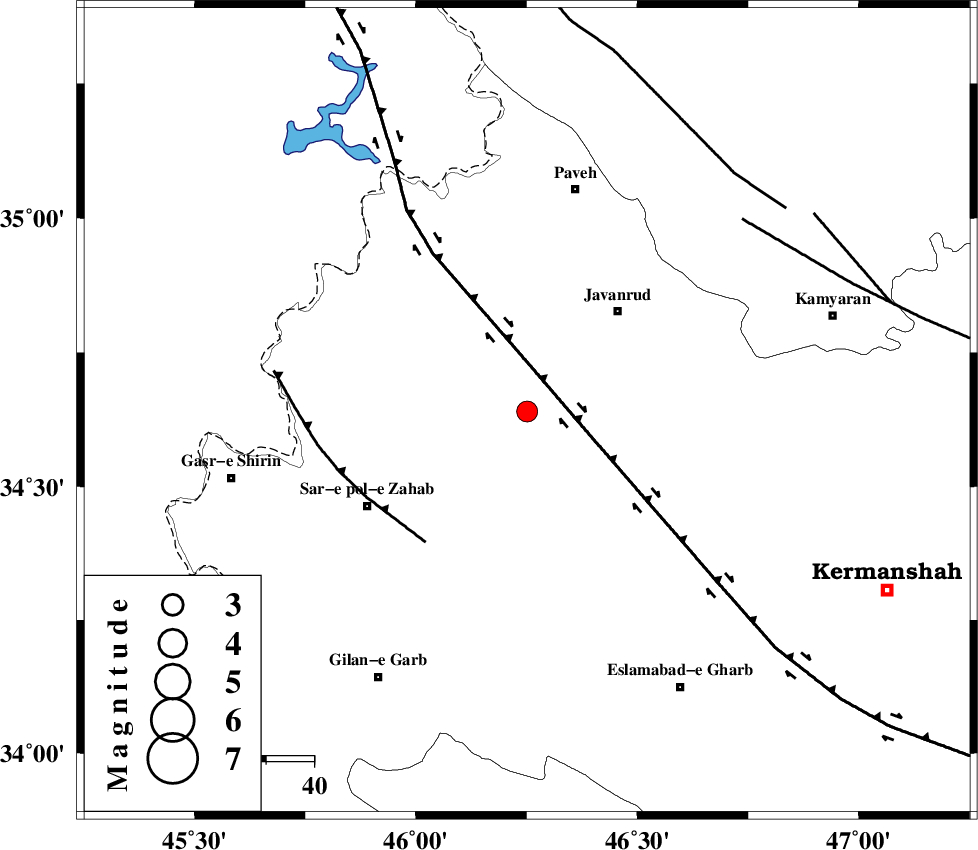
| Location | Lat:34.64 Lon: 46.251 |
| Region | Kermanshah Province, 28 km South-West of Javanrud |
Nearest Cities |
|
| 7 km of Mirabad, Kermanshah Province | |
| 12 km of Qolqoleh, Kermanshah Province | |
| 17 km North of Zavleh olia, Kermanshah Province | |
| 21 km West of Dolatabad, Kermanshah Province | |
| 23 km South West of Sarukhan, Kermanshah Province | |
| Depth | 14 km |
| Agency | |
Faults within 150 km: |
|
| HZF4 (Length: 492 km) , Distance to epicenter: 13 km | |
| MFF8 (Length: 48 km) , Distance to epicenter: 34 km | |
| SARTAKHT_F (Length: 78 km) , Distance to epicenter: 60 km | |
| Number of Phases | 8 |
| RMS | 0.2 |
| Number of Stations | 6 |
| Error in Latitude | >2.8 km |
| Error in Longitude | 5.3 km |
| Error in Depth | 3.1 km |
Download waveform in seisan format
to download seisan software Click here
to access information about IIEES stations Click here
Amplitude | ||||||||
| UID | Agency | Station | Component | Amplitude | Period | Arrival Time | Proccessing Time | Signal Clip |
| 135222 | IIEES | ILBA | E | 382.1 | 0.37 | 2018-07-28 01:54:22 | 2018-07-28 08:15:00 | n |
| 135223 | IIEES | ILBA | N | 359.9 | 0.21 | 2018-07-28 01:54:27 | 2018-07-28 08:15:00 | n |
| 135224 | IIEES | GHVR | E | 8.4 | 0.54 | 2018-07-28 01:56:12 | 2018-07-28 08:15:00 | n |
| 135225 | IIEES | GHVR | N | 8.5 | 0.48 | 2018-07-28 01:56:13 | 2018-07-28 08:15:00 | n |
Phase | ||||||||||||
| Agency | Station | Component | Phase Type | Phase Quality | First Motion | Observed Arrival Time | Time Residual | Loc. Flag | Input Weight | Distance | Azimuth | |
| IIEES | SNGE | Z | Pg | E | 2018-07-28 01:54:07 | -0.22 | y | 112 | 63 | |||
| IIEES | SNGE | E | Sg | E | 2018-07-28 01:54:21 | 0 | y | 112 | 63 | |||
| IIEES | ILBA | Z | Pg | E | 2018-07-28 01:54:07 | 0.09 | y | 113 | 182 | |||
| IIEES | ILBA | N | Sg | E | 2018-07-28 01:54:21 | -0.11 | y | 113 | 182 | |||
| IIEES | ZNJK | Z | Pn | E | 2018-07-28 01:54:35 | -0.02 | y | 315 | 44 | |||
| IIEES | ASAO | Z | Pn | E | 2018-07-28 01:54:39 | 0.21 | y | 346 | 91 | |||
| IIEES | KHMZ | Z | Pn | E | 2018-07-28 01:54:41 | 0.25 | y | 356 | 105 | |||
| IIEES | GHVR | Z | Pn | E | 2018-07-28 01:54:53 | -0.2 | y | 459 | 91 | |||