
Magnitude |
2.7 |
| Date & Time (UTC) | 2018-09-05 06:34:07.7 |
| Date & Time (Local) | 1397/6/14 11:04:07.7 |
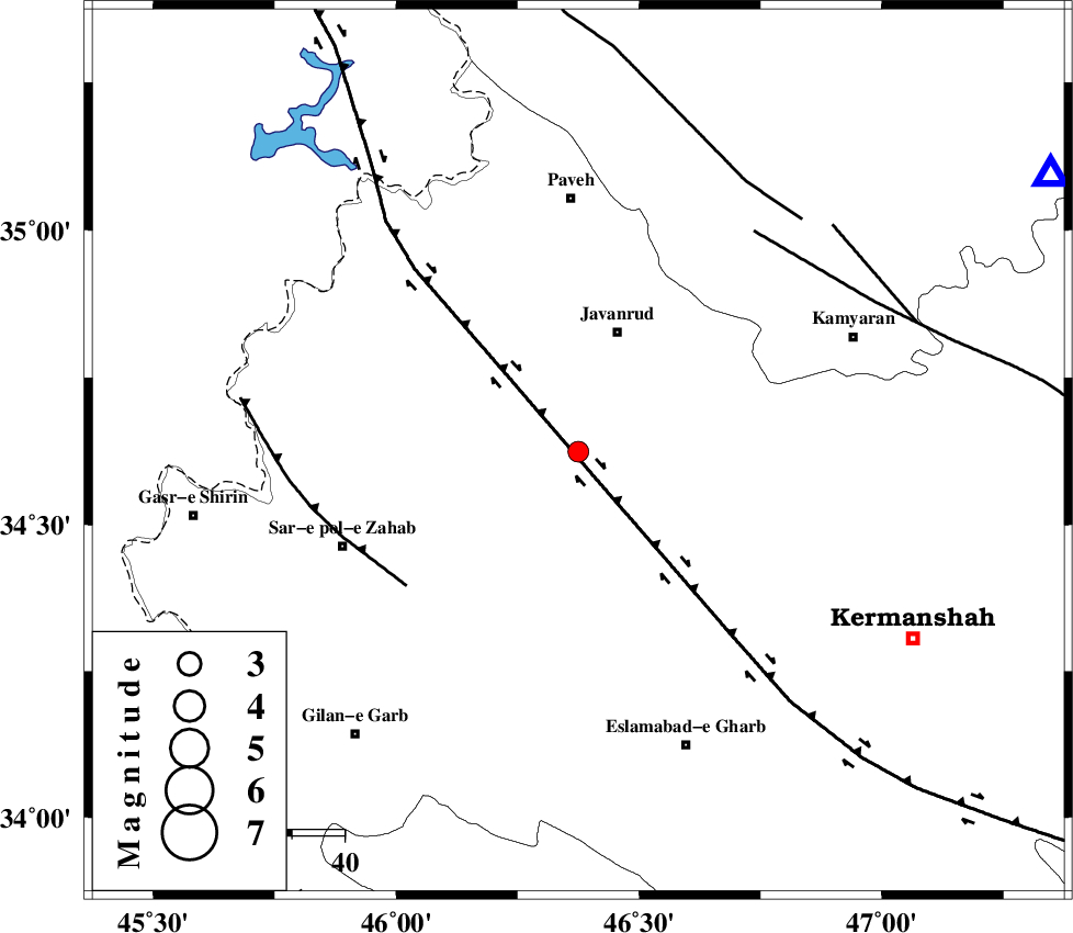
| Location | Lat:34.624 Lon: 46.375 |
| Region | Kermanshah Province, 24 km South of Javanrud |
Nearest Cities |
|
| 9 km of Mirabad, Kermanshah Province | |
| 11 km of Dolatabad, Kermanshah Province | |
| 15 km North of Zavleh olia, Kermanshah Province | |
| 17 km South of Sarukhan, Kermanshah Province | |
| 22 km North West of Kuzran, Kermanshah Province | |
| Depth | 14 km |
| Agency | |
Faults within 150 km: |
|
| HZF4 (Length: 492 km) , Distance to epicenter: 6 km | |
| MFF8 (Length: 48 km) , Distance to epicenter: 41 km | |
| SARTAKHT_F (Length: 78 km) , Distance to epicenter: 53 km | |
| Number of Phases | 6 |
| RMS | 0.2 |
| Number of Stations | 5 |
| Error in Latitude | >1.7 km |
| Error in Longitude | 3.3 km |
| Error in Depth | 5.7 km |
Download waveform in seisan format
to download seisan software Click here
to access information about IIEES stations Click here
Amplitude | ||||||||
| UID | Agency | Station | Component | Amplitude | Period | Arrival Time | Proccessing Time | Signal Clip |
| 136488 | IIEES | ILBA | N | 161.5 | 0.3 | 2018-09-05 06:34:49 | 2018-09-05 10:59:00 | n |
| 136489 | IIEES | SRSL | N | 96.3 | 0.44 | 2018-09-05 06:35:10 | 2018-09-05 10:59:00 | n |
| 136490 | IIEES | SRSL | E | 73.8 | 0.5 | 2018-09-05 06:35:10 | 2018-09-05 10:59:00 | n |
Phase | ||||||||||||
| Agency | Station | Component | Phase Type | Phase Quality | First Motion | Observed Arrival Time | Time Residual | Loc. Flag | Input Weight | Distance | Azimuth | |
| IIEES | SNGE | Z | Pg | E | 2018-09-05 06:34:25 | -0.26 | y | 103 | 59 | |||
| IIEES | ILBA | Z | Pg | E | 2018-09-05 06:34:26 | -0.11 | y | 112 | 188 | |||
| IIEES | SRSL | Z | Pg | E | 2018-09-05 06:34:40 | 0.09 | y | 196 | 334 | |||
| IIEES | SRSL | N | Sg | E | 2018-09-05 06:35:03 | 0.02 | y | 196 | 334 | |||
| IIEES | ASAO | Z | Pn | E | 2018-09-05 06:34:57 | 0.04 | y | 335 | 90 | |||
| IIEES | KHMZ | Z | Pn | E | 2018-09-05 06:34:58 | 0.26 | y | 345 | 106 | |||