
Magnitude |
2.6 |
| Date & Time (UTC) | 2018-12-10 12:52:41.3 |
| Date & Time (Local) | 1397/9/19 16:22:41.3 |
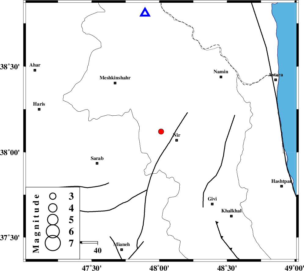
| Location | Lat:38.12 Lon: 48.012 |
| Region | Ardebil Province, 12 km -West of Nir |
Nearest Cities |
|
| 4 km of Eslamabad, Ardebil Province | |
| 9 km of Varniab, Ardebil Province | |
| 11 km North West of Rezaqoli qeshlaq, Ardebil Province | |
| 12 km North West of Nir, Ardebil Province | |
| 13 km West of Sareyin, Ardebil Province | |
| Depth | 16 km |
| Agency | |
Faults within 150 km: |
|
| BOZQUSH (Length: 70 km) , Distance to epicenter: 16 km | |
| SANGAVAR_F (Length: 61 km) , Distance to epicenter: 42 km | |
| MASULEL_F (Length: 90 km) , Distance to epicenter: 68 km | |
| Number of Phases | 6 |
| RMS | 0.1 |
| Number of Stations | 4 |
| Error in Latitude | >1.4 km |
| Error in Longitude | 4.3 km |
| Error in Depth | 4.1 km |
Download waveform in seisan format
to download seisan software Click here
to access information about IIEES stations Click here
Amplitude | ||||||||
| UID | Agency | Station | Component | Amplitude | Period | Arrival Time | Proccessing Time | Signal Clip |
| 139226 | IIEES | GIDE | E | 38.2 | 0.49 | 2018-12-10 12:53:45 | 2018-12-11 08:05:00 | n |
| 139227 | IIEES | GIDE | N | 52.5 | 0.32 | 2018-12-10 12:53:48 | 2018-12-11 08:05:00 | n |
Phase | ||||||||||||
| Agency | Station | Component | Phase Type | Phase Quality | First Motion | Observed Arrival Time | Time Residual | Loc. Flag | Input Weight | Distance | Azimuth | |
| IIEES | GRMI | Z | Pg | E | 2018-12-10 12:52:54 | 0.02 | y | 77.1 | 352 | |||
| IIEES | GRMI | N | Sg | E | 2018-12-10 12:53:04 | -0.06 | y | 77.1 | 352 | |||
| IIEES | ZNJK | Z | Pg | E | 2018-12-10 12:53:10 | 0.26 | y | 172 | 159 | |||
| IIEES | ZNJK | N | Sg | E | 2018-12-10 12:53:30 | -0.2 | y | 172 | 159 | |||
| IIEES | GIDE | Z | Pn | E | 2018-12-10 12:53:15 | 0.01 | y | 214 | 128 | |||
| IIEES | SRSL | Z | Pn | E | 2018-12-10 12:53:27 | -0.02 | y | 312 | 228 | |||