
Magnitude |
2.6 |
| Date & Time (UTC) | 2019-01-07 18:41:33.4 |
| Date & Time (Local) | 1397/10/17 22:11:33.4 |
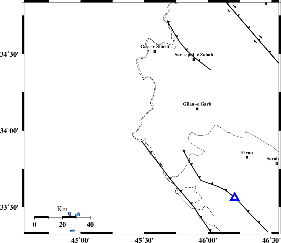
| Location | Lat:34.085 Lon: 45.556 |
| Region | Kermanshah Province, 34 km -West of Gilan-E-Gharb |
Nearest Cities |
|
| 24 km North of Sumar, Kermanshah Province | |
| 34 km West of Gilan-E-Gharb, Kermanshah Province | |
| 36 km South of Khosravi, Kermanshah Province | |
| 37 km North West of Nian, Kermanshah Province | |
| 38 km South West of Chub baghan, Kermanshah Province | |
| Depth | 14 km |
| Agency | |
Faults within 150 km: |
|
| ZFF4 (Length: 128 km) , Distance to epicenter: 18 km | |
| MFF7 (Length: 99 km) , Distance to epicenter: 33 km | |
| MFF8 (Length: 48 km) , Distance to epicenter: 54 km | |
| Number of Phases | 7 |
| RMS | 0.3 |
| Number of Stations | 5 |
| Error in Latitude | >2.7 km |
| Error in Longitude | 4.8 km |
| Error in Depth | 6.2 km |
Download waveform in seisan format
to download seisan software Click here
to access information about IIEES stations Click here
Amplitude | ||||||||
| UID | Agency | Station | Component | Amplitude | Period | Arrival Time | Proccessing Time | Signal Clip |
| 139900 | IIEES | ILBA | N | 235 | 0.44 | 2019-01-07 18:42:06 | 2019-01-08 07:52:00 | n |
| 139901 | IIEES | SNGE | N | 32.2 | 0.43 | 2019-01-07 18:42:34 | 2019-01-08 07:52:00 | n |
| 139902 | IIEES | SNGE | E | 35.6 | 0.62 | 2019-01-07 18:42:39 | 2019-01-08 07:52:00 | n |
| 139903 | IIEES | SRSL | E | 78.4 | 0.45 | 2019-01-07 18:42:45 | 2019-01-08 07:52:00 | n |
| 139904 | IIEES | ASAO | E | 8.6 | 0.59 | 2019-01-07 18:43:19 | 2019-01-08 07:52:00 | n |
| 139905 | IIEES | ASAO | N | 7.1 | 0.41 | 2019-01-07 18:43:20 | 2019-01-08 07:52:00 | n |
Phase | ||||||||||||
| Agency | Station | Component | Phase Type | Phase Quality | First Motion | Observed Arrival Time | Time Residual | Loc. Flag | Input Weight | Distance | Azimuth | |
| IIEES | ILBA | Z | Pg | E | 2019-01-07 18:41:46 | -0.25 | y | 79 | 130 | |||
| IIEES | SNGE | Z | Pg | E | 2019-01-07 18:42:05 | -0.29 | y | 199 | 55 | |||
| IIEES | SNGE | N | Sg | E | 2019-01-07 18:42:30 | 0.16 | y | 199 | 55 | |||
| IIEES | SRSL | Z | Pn | E | 2019-01-07 18:42:11 | 0.39 | y | 236 | 357 | |||
| IIEES | SRSL | N | Sg | E | 2019-01-07 18:42:40 | -0.26 | y | 236 | 357 | |||
| IIEES | KHMZ | Z | Pn | E | 2019-01-07 18:42:32 | 0.26 | y | 409 | 94 | |||
| IIEES | ASAO | Z | Pn | E | 2019-01-07 18:42:32 | 0.06 | y | 415 | 82 | |||