
Magnitude |
2.8 |
| Date & Time (UTC) | 2019-01-21 11:13:55.1 |
| Date & Time (Local) | 1397/11/1 14:43:55.1 |
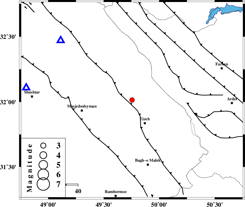
| Location | Lat:32.014 Lon: 49.755 |
| Region | Khoozestan Province, 23 km North-West of Izeh |
Nearest Cities |
|
| 7 km North of Torshak, Khoozestan Province | |
| 17 km North of Rasvand, Khoozestan Province | |
| 23 km North West of Izeh, Khoozestan Province | |
| 25 km North of Chenarestan, Khoozestan Province | |
| 36 km South East of Paabshalal, Khoozestan Province | |
| Depth | 14 km |
| Agency | |
Faults within 150 km: |
|
| MFF2 (Length: 205 km) , Distance to epicenter: 3 km | |
| ZARDKUH_F (Length: 139 km) , Distance to epicenter: 42 km | |
| DEZFUL_EMBAYMENT (Length: 228 km) , Distance to epicenter: 45 km | |
| Number of Phases | 7 |
| RMS | 0.2 |
| Number of Stations | 5 |
| Error in Latitude | >3 km |
| Error in Longitude | 4.3 km |
| Error in Depth | 4 km |
Download waveform in seisan format
to download seisan software Click here
to access information about IIEES stations Click here
Amplitude | ||||||||
| UID | Agency | Station | Component | Amplitude | Period | Arrival Time | Proccessing Time | Signal Clip |
| 140450 | IIEES | KHMZ | E | 87.8 | 0.33 | 2019-01-21 11:14:54 | 2019-01-22 11:42:00 | n |
| 140451 | IIEES | ASAO | E | 27.7 | 0.52 | 2019-01-21 11:15:23 | 2019-01-22 11:42:00 | n |
| 140452 | IIEES | ASAO | N | 28.5 | 0.43 | 2019-01-21 11:15:28 | 2019-01-22 11:42:00 | n |
| 140453 | IIEES | GHVR | E | 28.3 | 0.39 | 2019-01-21 11:15:26 | 2019-01-22 11:42:00 | n |
| 140454 | IIEES | GHVR | N | 24.1 | 0.45 | 2019-01-21 11:15:31 | 2019-01-22 11:42:00 | n |
| 140455 | IIEES | ILBA | E | 24.4 | 0.45 | 2019-01-21 11:15:33 | 2019-01-22 11:42:00 | n |
Phase | ||||||||||||
| Agency | Station | Component | Phase Type | Phase Quality | First Motion | Observed Arrival Time | Time Residual | Loc. Flag | Input Weight | Distance | Azimuth | |
| IIEES | KHMZ | Z | Pg | E | 2019-01-21 11:14:26 | -0.32 | y | 192 | 6 | |||
| IIEES | KHMZ | N | Sg | E | 2019-01-21 11:14:50 | 0.06 | y | 192 | 6 | |||
| IIEES | ASAO | Z | Pn | E | 2019-01-21 11:14:38 | 0.12 | y | 282 | 5 | |||
| IIEES | ASAO | N | S | E | 2019-01-21 11:15:09 | -0.05 | y | 282 | 5 | |||
| IIEES | NASN | Z | Pn | E | 2019-01-21 11:14:40 | -0.14 | y | 300 | 72 | |||
| IIEES | GHVR | Z | Pn | E | 2019-01-21 11:14:41 | 0.36 | y | 307 | 27 | |||
| IIEES | ILBA | Z | Pn | E | 2019-01-21 11:14:49 | 0 | y | 377 | 299 | |||