
Magnitude |
2.9 |
| Date & Time (UTC) | 2019-11-22 22:54:15.6 |
| Date & Time (Local) | 1398/9/2 02:24:15.6 |
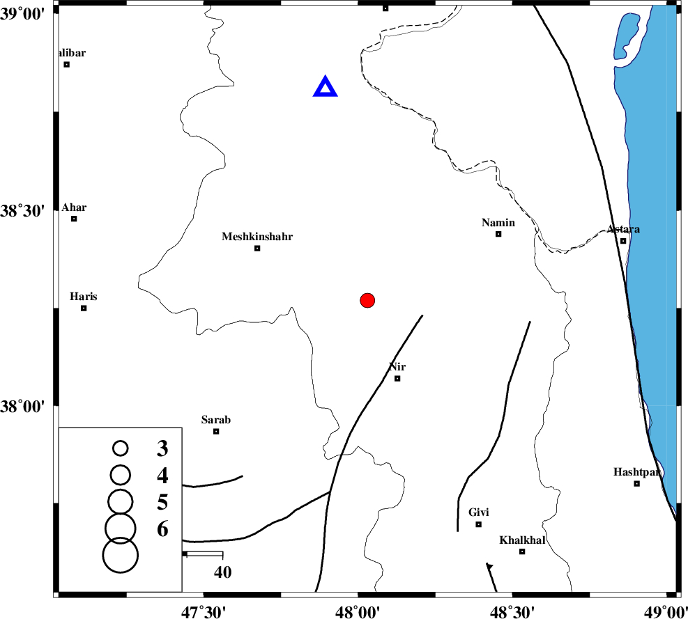
| Location | Lat:38.27 Lon: 48.03 |
| Region | Ardebil Province, 24 km -West of Ardabil |
Nearest Cities |
|
| 8 km North of Sardabeh, Ardebil Province | |
| 9 km West of Khoshkehrud, Ardebil Province | |
| 11 km of Samarin, Ardebil Province | |
| 12 km North of Sareyin, Ardebil Province | |
| 13 km North West of Ardimusa, Ardebil Province | |
| Depth | 10 km |
| Agency | |
Faults within 150 km: |
|
| BOZQUSH (Length: 70 km) , Distance to epicenter: 16 km | |
| SANGAVAR_F (Length: 61 km) , Distance to epicenter: 46 km | |
| TALESH_F (Length: 258 km) , Distance to epicenter: 73 km | |
| Number of Phases | 7 |
| RMS | 0.4 |
| Number of Stations | 7 |
| Error in Latitude | >5 km |
| Error in Longitude | 0 km |
| Error in Depth | 14 km |
Download waveform in seisan format
to download seisan software Click here
to access information about IIEES stations Click here
Amplitude | ||||||||
| UID | Agency | Station | Component | Amplitude | Period | Arrival Time | Proccessing Time | Signal Clip |
| 148733 | IIEES SC | GRMI | Z | 470 | 1 | 2019-11-22 22:54:37 | 2019-11-23 10:53:00 | n |
| 148734 | IIEES SC | ZNJK | Z | 3.8 | 1 | 2019-11-22 22:54:54 | 2019-11-23 10:53:00 | n |
| 148735 | IIEES SC | SRSL | Z | 21 | 1 | 2019-11-22 22:55:50 | 2019-11-23 10:53:00 | n |
| 148736 | IIEES SC | SNGE | Z | 24 | 1 | 2019-11-22 22:57:06 | 2019-11-23 10:53:00 | n |
| 148737 | IIEES SC | THKV | Z | 12 | 1 | 2019-11-22 22:56:07 | 2019-11-23 10:53:00 | n |
Phase | ||||||||||||
| Agency | Station | Component | Phase Type | Phase Quality | First Motion | Observed Arrival Time | Time Residual | Loc. Flag | Input Weight | Distance | Azimuth | |
| IIEES SC | GRMI | Z | IP | I | 2019-11-22 22:54:26 | -0.1 | y | 55 | 349 | |||
| IIEES SC | ZNJK | Z | IP | I | 2019-11-22 22:54:44 | -1.6 | y | 189 | 162 | |||
| IIEES SC | MAHB | Z | IP | I | 2019-11-22 22:54:56 | -0.1 | y | 266 | 231 | |||
| IIEES SC | QABG | Z | IP | I | 2019-11-22 22:55:02 | -0.8 | y | 311 | 154 | |||
| IIEES SC | SRSL | Z | IP | I | 2019-11-22 22:55:05 | 1.1 | y | 322 | 225 | |||
| IIEES SC | SNGE | Z | IP | I | 2019-11-22 22:55:08 | -0.2 | y | 355 | 190 | |||
| IIEES SC | THKV | Z | IP | I | 2019-11-22 22:55:09 | 0.2 | y | 366 | 136 | |||