
Magnitude |
2.8 |
| Date & Time (UTC) | 2019-12-08 02:09:06.9 |
| Date & Time (Local) | 1398/9/17 05:39:06.9 |
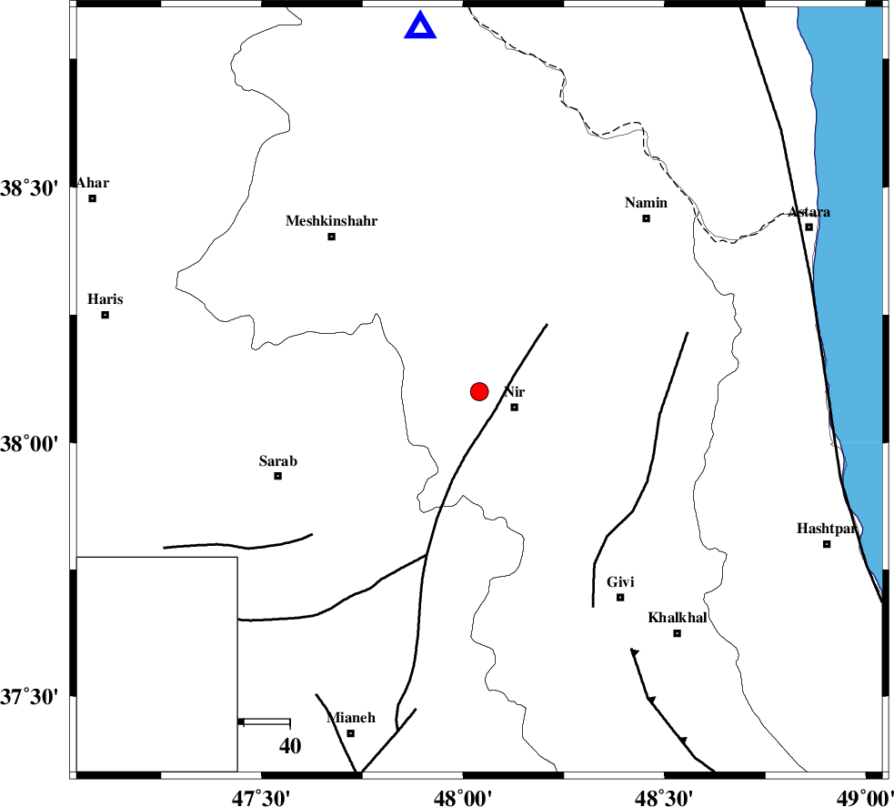
| Location | Lat:38.1 Lon: 48.04 |
| Region | Ardebil Province, 8 km of Nir |
Nearest Cities |
|
| 4 km of Eslamabad, Ardebil Province | |
| 8 km of Rezaqoli qeshlaq, Ardebil Province | |
| 8 km North of Nir, Ardebil Province | |
| 8 km of Varniab, Ardebil Province | |
| 12 km of Sareyin, Ardebil Province | |
| Depth | 10 km |
| Agency | |
Faults within 150 km: |
|
| BOZQUSH (Length: 70 km) , Distance to epicenter: 14 km | |
| SANGAVAR_F (Length: 61 km) , Distance to epicenter: 39 km | |
| MASULEL_F (Length: 90 km) , Distance to epicenter: 65 km | |
| Number of Phases | 9 |
| RMS | 0.3 |
| Number of Stations | 8 |
| Error in Latitude | >1 km |
| Error in Longitude | 0 km |
| Error in Depth | 9 km |
Download waveform in seisan format
to download seisan software Click here
to access information about IIEES stations Click here
Amplitude | ||||||||
| UID | Agency | Station | Component | Amplitude | Period | Arrival Time | Proccessing Time | Signal Clip |
| 149420 | IIEES SC | GRMI | Z | 310 | 1 | 2019-12-08 02:09:32 | 2019-12-08 02:09:00 | n |
| 149421 | IIEES SC | ZNJK | Z | 4.4 | 1 | 2019-12-08 02:10:19 | 2019-12-08 02:09:00 | n |
| 149422 | IIEES SC | AZR | Z | 280 | 1 | 2019-12-08 02:10:04 | 2019-12-08 02:09:00 | n |
| 149423 | IIEES SC | GIDE | Z | 99 | 1 | 2019-12-08 02:10:12 | 2019-12-08 02:09:00 | n |
| 149424 | IIEES SC | MAHB | Z | 28 | 1 | 2019-12-08 02:10:22 | 2019-12-08 02:09:00 | n |
| 149425 | IIEES SC | SNGE | Z | 9.6 | 1 | 2019-12-08 02:10:42 | 2019-12-08 02:09:00 | n |
Phase | ||||||||||||
| Agency | Station | Component | Phase Type | Phase Quality | First Motion | Observed Arrival Time | Time Residual | Loc. Flag | Input Weight | Distance | Azimuth | |
| IIEES SC | GRMI | N | IS | I | 2019-12-08 02:09:31 | -0.3 | y | 77 | 351 | |||
| IIEES SC | GRMI | Z | IP | I | 2019-12-08 02:09:21 | 0.3 | y | 77 | 351 | |||
| IIEES SC | ZNJK | Z | IP | I | 2019-12-08 02:09:33 | -0.8 | y | 166 | 160 | |||
| IIEES SC | ZNJK | Z | IS | I | 2019-12-08 02:09:53 | -1.8 | y | 166 | 160 | |||
| IIEES SC | AZR | Z | IP | I | 2019-12-08 02:09:37 | 0 | y | 189 | 256 | |||
| IIEES SC | GIDE | Z | IP | I | 2019-12-08 02:09:41 | 0.1 | y | 211 | 128 | |||
| IIEES SC | MAHB | Z | IP | I | 2019-12-08 02:09:46 | 0.1 | y | 255 | 235 | |||
| IIEES SC | MAKU | Z | IP | I | 2019-12-08 02:10:01 | 5.7 | n | 4 | 322 | 296 | ||
| IIEES SC | SNGE | Z | IP | I | 2019-12-08 02:09:58 | 0.6 | y | 344 | 191 | |||