
Magnitude |
2.7 |
| Date & Time (UTC) | 2019-12-27 19:12:55.4 |
| Date & Time (Local) | 1398/10/6 22:42:55.4 |
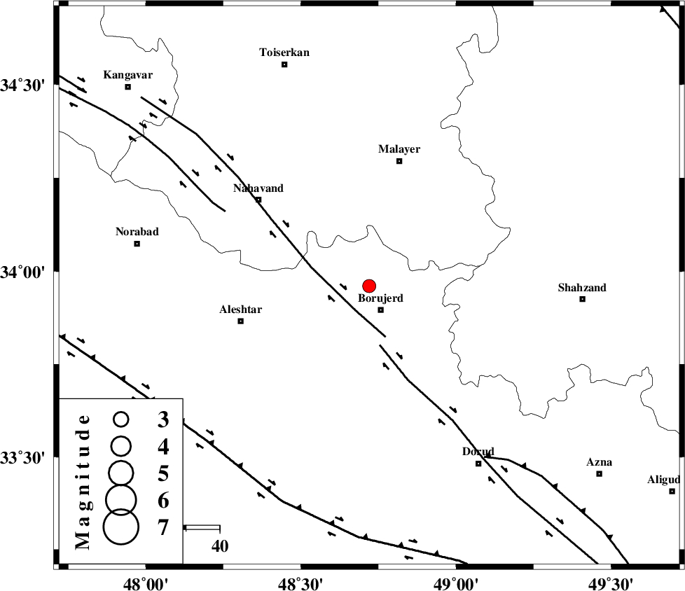
| Location | Lat:33.96 Lon: 48.72 |
| Region | Lorestan Province, 8 km of Borujerd |
Nearest Cities |
|
| 5 km of Bon dizeh, Lorestan Province | |
| 8 km North of Borujerd, Lorestan Province | |
| 9 km of Ashtarinan, Lorestan Province | |
| 10 km of Darre-ye gorg, Lorestan Province | |
| 15 km North West of Valanjerd, Lorestan Province | |
| Depth | 10 km |
| Agency | |
Faults within 150 km: |
|
| NAHAVAND_F (Length: 102 km) , Distance to epicenter: 8 km | |
| DORUD (Length: 100 km) , Distance to epicenter: 18 km | |
| SAHANEH_F (Length: 77 km) , Distance to epicenter: 48 km | |
| Number of Phases | 7 |
| RMS | 0.3 |
| Number of Stations | 7 |
| Error in Latitude | >3 km |
| Error in Longitude | 0 km |
| Error in Depth | 8 km |
Download waveform in seisan format
to download seisan software Click here
to access information about IIEES stations Click here
Amplitude | ||||||||
| UID | Agency | Station | Component | Amplitude | Period | Arrival Time | Proccessing Time | Signal Clip |
| 150100 | IIEES SC | ASAO | Z | 64 | 1 | 2019-12-27 19:13:39 | 2019-12-28 11:54:00 | n |
| 150101 | IIEES SC | GTMR | Z | 30 | 1 | 2019-12-27 19:13:46 | 2019-12-28 11:54:00 | n |
| 150102 | IIEES SC | GHVR | Z | 220 | 1 | 2019-12-27 19:14:18 | 2019-12-28 11:54:00 | n |
Phase | ||||||||||||
| Agency | Station | Component | Phase Type | Phase Quality | First Motion | Observed Arrival Time | Time Residual | Loc. Flag | Input Weight | Distance | Azimuth | |
| IIEES SC | ASAO | N | IS | I | 2019-12-27 19:13:35 | 0 | y | 133 | 62 | |||
| IIEES SC | ASAO | Z | IP | I | 2019-12-27 19:13:18 | -0.2 | y | 133 | 62 | |||
| IIEES SC | GTMR | N | IS | I | 2019-12-27 19:13:44 | 0.1 | y | 166 | 168 | |||
| IIEES SC | GTMR | Z | IP | I | 2019-12-27 19:13:23 | -0.3 | y | 166 | 168 | |||
| IIEES SC | QABG | N | IS | I | 2019-12-27 19:13:54 | -0.4 | y | 211 | 22 | |||
| IIEES SC | QABG | Z | IP | I | 2019-12-27 19:13:30 | 0.5 | y | 211 | 22 | |||
| IIEES SC | GHVR | Z | IP | I | 2019-12-27 19:13:34 | 0.6 | y | 244 | 76 | |||