
Magnitude |
2.8 |
| Date & Time (UTC) | 2019-12-26 05:13:05.4 |
| Date & Time (Local) | 1398/10/5 08:43:05.4 |
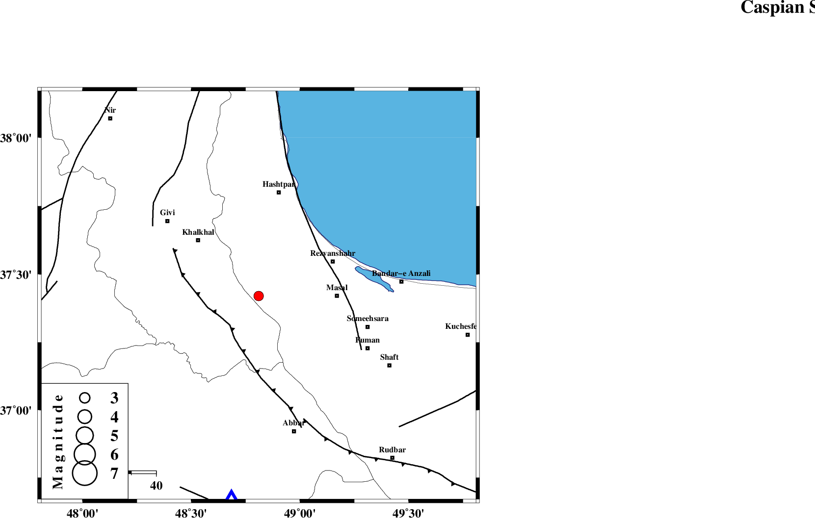
| Location | Lat:37.42 Lon: 48.81 |
| Region | Gilan Province, 32 km -West of Masal |
Nearest Cities |
|
| 9 km North of Kalur, Ardebil Province | |
| 9 km North of Shal, Ardebil Province | |
| 16 km South of Ardeh, Gilan Province | |
| 17 km North East of Karin, Ardebil Province | |
| 27 km West of Shangavar, Gilan Province | |
| Depth | 10 km |
| Agency | |
Faults within 150 km: |
|
| MASULEL_F (Length: 90 km) , Distance to epicenter: 17 km | |
| TALESH_F (Length: 258 km) , Distance to epicenter: 31 km | |
| SANGAVAR_F (Length: 61 km) , Distance to epicenter: 52 km | |
| Number of Phases | 9 |
| RMS | 0.6 |
| Number of Stations | 9 |
| Error in Latitude | >4 km |
| Error in Longitude | 0 km |
| Error in Depth | 7 km |
Download waveform in seisan format
to download seisan software Click here
to access information about IIEES stations Click here
Amplitude | ||||||||
| UID | Agency | Station | Component | Amplitude | Period | Arrival Time | Proccessing Time | Signal Clip |
| 150138 | IIEES SC | ZNJK | Z | 3.4 | 1 | 2019-12-26 05:14:12 | 2019-12-28 02:20:00 | n |
| 150139 | IIEES SC | GIDE | Z | 340 | 1 | 2019-12-26 05:13:37 | 2019-12-28 02:20:00 | n |
| 150140 | IIEES SC | GRMI | Z | 59 | 1 | 2019-12-26 05:13:56 | 2019-12-28 02:20:00 | n |
| 150141 | IIEES SC | THKV | Z | 51 | 1 | 2019-12-26 05:14:16 | 2019-12-28 02:20:00 | n |
| 150142 | IIEES SC | CHTH | Z | 2.3 | 1 | 2019-12-26 05:14:33 | 2019-12-28 02:20:00 | n |
Phase | ||||||||||||
| Agency | Station | Component | Phase Type | Phase Quality | First Motion | Observed Arrival Time | Time Residual | Loc. Flag | Input Weight | Distance | Azimuth | |
| IIEES SC | ZNJK | Z | IP | I | 2019-12-26 05:13:20 | 0.5 | y | 88 | 188 | |||
| IIEES SC | GIDE | Z | IP | I | 2019-12-26 05:13:23 | -0.9 | y | 111 | 120 | |||
| IIEES SC | GRMI | N | IS | I | 2019-12-26 05:13:55 | -0.2 | y | 177 | 332 | |||
| IIEES SC | GRMI | Z | IP | I | 2019-12-26 05:13:34 | 0.1 | y | 177 | 332 | |||
| IIEES SC | QABG | E | IS | I | 2019-12-26 05:14:03 | -0.4 | y | 200 | 160 | |||
| IIEES SC | QABG | Z | IP | I | 2019-12-26 05:13:37 | -0.7 | y | 200 | 160 | |||
| IIEES SC | THKV | N | IS | I | 2019-12-26 05:14:15 | 1.1 | y | 244 | 132 | |||
| IIEES SC | THKV | Z | IP | I | 2019-12-26 05:13:45 | 0.8 | y | 244 | 132 | |||
| IIEES SC | CHTH | Z | IP | I | 2019-12-26 05:13:47 | 0.1 | y | 266 | 129 | |||