
Magnitude |
3.2 |
| Date & Time (UTC) | 2025-04-29 10:57:40.8 |
| Date & Time (Local) | 1404/2/9 14:27:40.8 |
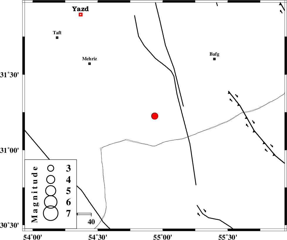
| Location | Lat:31.225 Lon: 54.938 |
| Region | Yazd Province, 61 km South-West of Bafq |
Nearest Cities |
|
| 12 km South of Bahadoran, Yazd Province | |
| 50 km North West of Anar, Kerman Province | |
| 58 km North West of Hoseiynabad-e amin, Kerman Province | |
| 59 km North of Dehaj, Kerman Province | |
| 61 km South West of Bafq, Yazd Province | |
| Depth | 12 km |
| Agency | |
Faults within 150 km: |
|
| ANAR_F (Length: 91 km) , Distance to epicenter: 22 km | |
| ANAR_F (Length: 127 km) , Distance to epicenter: 23 km | |
| DARIVAN_F (Length: 131 km) , Distance to epicenter: 57 km | |
| Number of Phases | 8 |
| RMS | 0.4 |
| Number of Stations | 8 |
| Error in Latitude | >2.6 km |
| Error in Longitude | 2.6 km |
| Error in Depth | 17 km |
Download waveform in seisan format
to download seisan software Click here
to access information about IIEES stations Click here
Amplitude | ||||||||
| UID | Agency | Station | Component | Amplitude | Period | Arrival Time | Proccessing Time | Signal Clip |
| 198028 | IIEES SC | NASN | Z | 0.2 | 1 | 2025-04-29 10:58:21 | 2025-04-30 04:26:00 | n |
| 198029 | IIEES SC | SHRO | Z | 0.02 | 1 | 2025-04-29 10:58:55 | 2025-04-30 04:26:00 | n |
| 198030 | IIEES SC | SHRT | Z | 0.02 | 1 | 2025-04-29 10:59:00 | 2025-04-30 04:26:00 | n |
Phase | ||||||||||||
| Agency | Station | Component | Phase Type | Phase Quality | First Motion | Observed Arrival Time | Time Residual | Loc. Flag | Input Weight | Distance | Azimuth | |
| IIEES SC | YZKH | Z | EPg | E | 2025-04-29 10:58:03 | 0.1 | y | 0 | 133 | 346 | ||
| IIEES SC | KRBR | Z | EPn | E | 2025-04-29 10:58:16 | -0.3 | y | 0 | 222 | 128 | ||
| IIEES SC | NASN | Z | EPn | E | 2025-04-29 10:58:21 | -0.4 | y | 0 | 266 | 311 | ||
| IIEES SC | TABS | Z | EPn | E | 2025-04-29 10:58:31 | 0.7 | y | 0 | 338 | 37 | ||
| IIEES SC | GHIR | Z | EPn | E | 2025-04-29 10:58:35 | 0.3 | y | 0 | 377 | 210 | ||
| IIEES SC | BSRN | Z | EPn | E | 2025-04-29 10:58:27 | -12.1 | n | 4 | 406 | 78 | ||
| IIEES SC | SHRO | Z | EPn | E | 2025-04-29 10:58:55 | -0.4 | y | 0 | 540 | 11 | ||
| IIEES SC | SHRT | Z | EPn | E | 2025-04-29 10:59:00 | 0.6 | y | 0 | 570 | 62 | ||