
Magnitude |
3.3 |
| Date & Time (UTC) | 2025-03-16 12:00:07.1 |
| Date & Time (Local) | 1403/12/26 15:30:07.1 |
| Location | Lat:29.573 Lon: 51.384 |
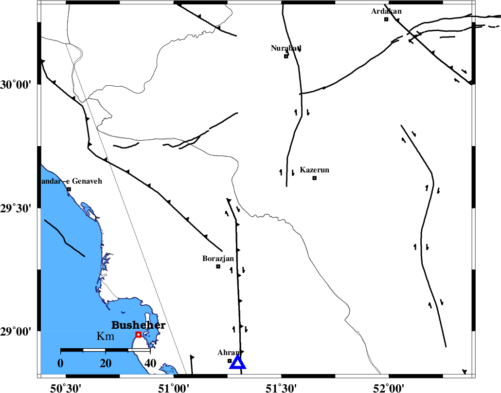
| Region | Fars Province, 27 km -West of Kazerun |
Nearest Cities |
|
| 5 km North of Khesht, Fars Province | |
| 11 km of Kamaraj, Fars Province | |
| 18 km North of Dalki, Bushehr Province | |
| 22 km South West of Deris, Fars Province | |
| 27 km West of Kazerun, Fars Province | |
| Depth | 12 km |
| Agency | |
Faults within 150 km: |
|
| KAZERUN_F (Length: 96 km) , Distance to epicenter: 14 km | |
| BORAZJAN_F (Length: 168 km) , Distance to epicenter: 14 km | |
| ZFF3 (Length: 125 km) , Distance to epicenter: 31 km | |
| Number of Phases | 7 |
| RMS | 0.7 |
| Number of Stations | 7 |
| Error in Latitude | >9.8 km |
| Error in Longitude | 9.8 km |
| Error in Depth | 999 km |
Download waveform in seisan format
to download seisan software Click here
to access information about IIEES stations Click here
Amplitude | ||||||||
| UID | Agency | Station | Component | Amplitude | Period | Arrival Time | Proccessing Time | Signal Clip |
| 198064 | IIEES SC | KRBR | Z | 0.03 | 1 | 2025-03-16 12:01:21 | 2025-05-03 07:58:00 | n |
| 198065 | IIEES SC | ASAO | Z | 0.02 | 1 | 2025-03-16 12:01:25 | 2025-05-03 07:58:00 | n |
| 198066 | IIEES SC | UOSS | Z | 0.01 | 1 | 2025-03-16 12:01:41 | 2025-05-03 07:58:00 | n |
Phase | ||||||||||||
| Agency | Station | Component | Phase Type | Phase Quality | First Motion | Observed Arrival Time | Time Residual | Loc. Flag | Input Weight | Distance | Azimuth | |
| IIEES SC | GHIR | Z | EPn | E | 2025-03-16 12:00:41 | -0.1 | y | 0 | 212 | 132 | ||
| IIEES SC | NASN | Z | EPn | E | 2025-03-16 12:01:03 | 0.8 | y | 0 | 383 | 21 | ||
| IIEES SC | YZKH | Z | EPn | E | 2025-03-16 12:01:08 | -0.9 | y | 0 | 438 | 44 | ||
| IIEES SC | KRBR | Z | EPn | E | 2025-03-16 12:01:21 | 1.1 | y | 0 | 522 | 85 | ||
| IIEES SC | ASAO | Z | EPn | E | 2025-03-16 12:01:25 | -0.4 | y | 0 | 566 | 347 | ||
| IIEES SC | DAMV | Z | EPn | E | 2025-03-16 12:01:51 | 13 | n | 4 | 674 | 5 | ||
| IIEES SC | UOSS | Z | EPn | E | 2025-03-16 12:01:41 | -0.4 | y | 0 | 701 | 137 | ||