
Magnitude |
3.3 |
| Date & Time (UTC) | 2025-05-15 07:28:09.4 |
| Date & Time (Local) | 1404/2/25 10:58:09.4 |
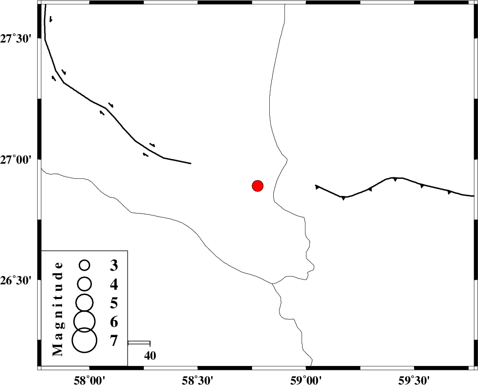
| Location | Lat:26.89 Lon: 58.776 |
| Region | Kerman Province, 139 km South-East of Manujan |
Nearest Cities |
|
| 7 km North of Ramashk, Kerman Province | |
| 63 km North West of Tutan, Sistan va Baloochestan Province | |
| 89 km South East of Keshmiran, Kerman Province | |
| 91 km South West of Kalemursi, Sistan va Baloochestan Province | |
| 91 km North West of Dastgerd, Sistan va Baloochestan Province | |
| Depth | 12 km |
| Agency | |
Faults within 150 km: |
|
| S_JAZMURIAN_F (Length: 91 km) , Distance to epicenter: 26 km | |
| JIROFT_F (Length: 144 km) , Distance to epicenter: 32 km | |
| LASHAR_F (Length: 68 km) , Distance to epicenter: 121 km | |
| Number of Phases | 7 |
| RMS | 0.2 |
| Number of Stations | 7 |
| Error in Latitude | >3.2 km |
| Error in Longitude | 3.2 km |
| Error in Depth | 15.9 km |
Download waveform in seisan format
to download seisan software Click here
to access information about IIEES stations Click here
Amplitude | ||||||||
| UID | Agency | Station | Component | Amplitude | Period | Arrival Time | Proccessing Time | Signal Clip |
| 198205 | IIEES SC | IRSR | Z | 0.3 | 1 | 2025-05-15 07:28:43 | 2025-05-17 04:01:00 | n |
| 198206 | IIEES SC | CHBR | Z | 0.5 | 1 | 2025-05-15 07:28:44 | 2025-05-17 04:01:00 | n |
| 198207 | IIEES SC | ZHSF | Z | 0.08 | 1 | 2025-05-15 07:29:02 | 2025-05-17 04:01:00 | n |
| 198208 | IIEES SC | KRBR | Z | 0.2 | 1 | 2025-05-15 07:29:06 | 2025-05-17 04:01:00 | n |
Phase | ||||||||||||
| Agency | Station | Component | Phase Type | Phase Quality | First Motion | Observed Arrival Time | Time Residual | Loc. Flag | Input Weight | Distance | Azimuth | |
| IIEES SC | IRSR | Z | EPn | E | 2025-05-15 07:28:43 | 0 | y | 0 | 207 | 87 | ||
| IIEES SC | CHBR | Z | EPn | E | 2025-05-15 07:28:44 | -0.1 | y | 0 | 223 | 130 | ||
| IIEES SC | ZHSF | Z | EPn | E | 2025-05-15 07:29:02 | 0.6 | y | 0 | 359 | 33 | ||
| IIEES SC | KRBR | Z | EPn | E | 2025-05-15 07:29:06 | -0.2 | y | 0 | 396 | 330 | ||
| IIEES SC | BSRN | Z | EPn | E | 2025-05-15 07:29:15 | -11.9 | n | 4 | 564 | 3 | ||
| IIEES SC | GHIR | Z | EPn | E | 2025-05-15 07:29:31 | 0.1 | y | 0 | 592 | 285 | ||
| IIEES SC | YZKH | Z | EPn | E | 2025-05-15 07:29:17 | -30.5 | n | 4 | 732 | 326 | ||