
Magnitude |
2.6 |
| Date & Time (UTC) | 2025-06-09 01:33:34.4 |
| Date & Time (Local) | 1404/3/19 05:03:34.4 |
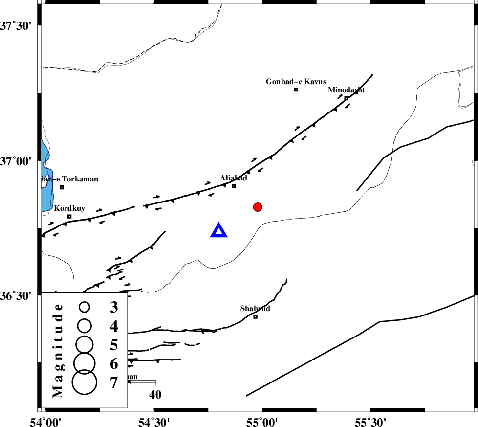
| Location | Lat:36.828 Lon: 54.978 |
| Region | Golestan Province, 13 km -East of Ali Abad |
Nearest Cities |
|
| 13 km East of Ali Abad, Golestan Province | |
| 20 km South of Khanbebin, Golestan Province | |
| 24 km North West of Qaleh-ye nokharqan, Semnan Province | |
| 24 km South of Deland, Golestan Province | |
| 25 km South West of Ramian, Golestan Province | |
| Depth | 10 km |
| Agency | |
Faults within 150 km: |
|
| SHAVAR_F (Length: 87 km) , Distance to epicenter: 16 km | |
| KHAZAR_F (Length: 523 km) , Distance to epicenter: 20 km | |
| ROBATE_QARABIL_F (Length: 168 km) , Distance to epicenter: 41 km | |
| Number of Phases | 10 |
| RMS | 0.4 |
| Number of Stations | 10 |
| Error in Latitude | >2.8 km |
| Error in Longitude | 2.8 km |
| Error in Depth | 4.5 km |
Download waveform in seisan format
to download seisan software Click here
to access information about IIEES stations Click here
Amplitude | ||||||||
| UID | Agency | Station | Component | Amplitude | Period | Arrival Time | Proccessing Time | Signal Clip |
| 198464 | IIEES SC | MRVT | Z | 0.2 | 1 | 2025-06-09 01:33:56 | 2025-06-09 08:06:00 | n |
| 198465 | IIEES SC | TABS | Z | 0.01 | 1 | 2025-06-09 01:34:33 | 2025-06-09 08:06:00 | n |
| 198466 | IIEES SC | NASN | Z | 0.01 | 1 | 2025-06-09 01:34:42 | 2025-06-09 08:06:00 | n |
Phase | ||||||||||||
| Agency | Station | Component | Phase Type | Phase Quality | First Motion | Observed Arrival Time | Time Residual | Loc. Flag | Input Weight | Distance | Azimuth | |
| IIEES SC | ABGH | Z | EPg | E | 2025-06-09 01:33:37 | -1 | y | 0 | 19 | 237 | ||
| IIEES SC | GLO | Z | EPg | E | 2025-06-09 01:33:53 | 0.3 | y | 0 | 109 | 251 | ||
| IIEES SC | SHRO | Z | EPg | E | 2025-06-09 01:33:49 | -7.1 | n | 4 | 130 | 134 | ||
| IIEES SC | MRVT | Z | EPg | E | 2025-06-09 01:33:56 | -0.3 | y | 0 | 135 | 47 | ||
| IIEES SC | BJRD | Z | EPn | E | 2025-06-09 01:34:12 | 0.1 | y | 0 | 236 | 66 | ||
| IIEES SC | DAMV | Z | EPn | E | 2025-06-09 01:34:00 | -20.1 | n | 4 | 301 | 244 | ||
| IIEES SC | TABS | Z | EPn | E | 2025-06-09 01:34:33 | 0.5 | y | 0 | 403 | 151 | ||
| IIEES SC | KAGH | Z | EPn | E | 2025-06-09 01:34:38 | 0.3 | y | 0 | 444 | 88 | ||
| IIEES SC | NASN | Z | EPn | E | 2025-06-09 01:34:42 | -0.6 | y | 0 | 489 | 204 | ||
| IIEES SC | SHRT | Z | EPn | E | 2025-06-09 01:34:43 | -13.7 | n | 4 | 599 | 126 | ||

 IIEES All Rights Reserved