
Magnitude |
3.4 |
| Date & Time (UTC) | 2025-07-19 22:13:18.8 |
| Date & Time (Local) | 1404/4/29 01:43:18.8 |
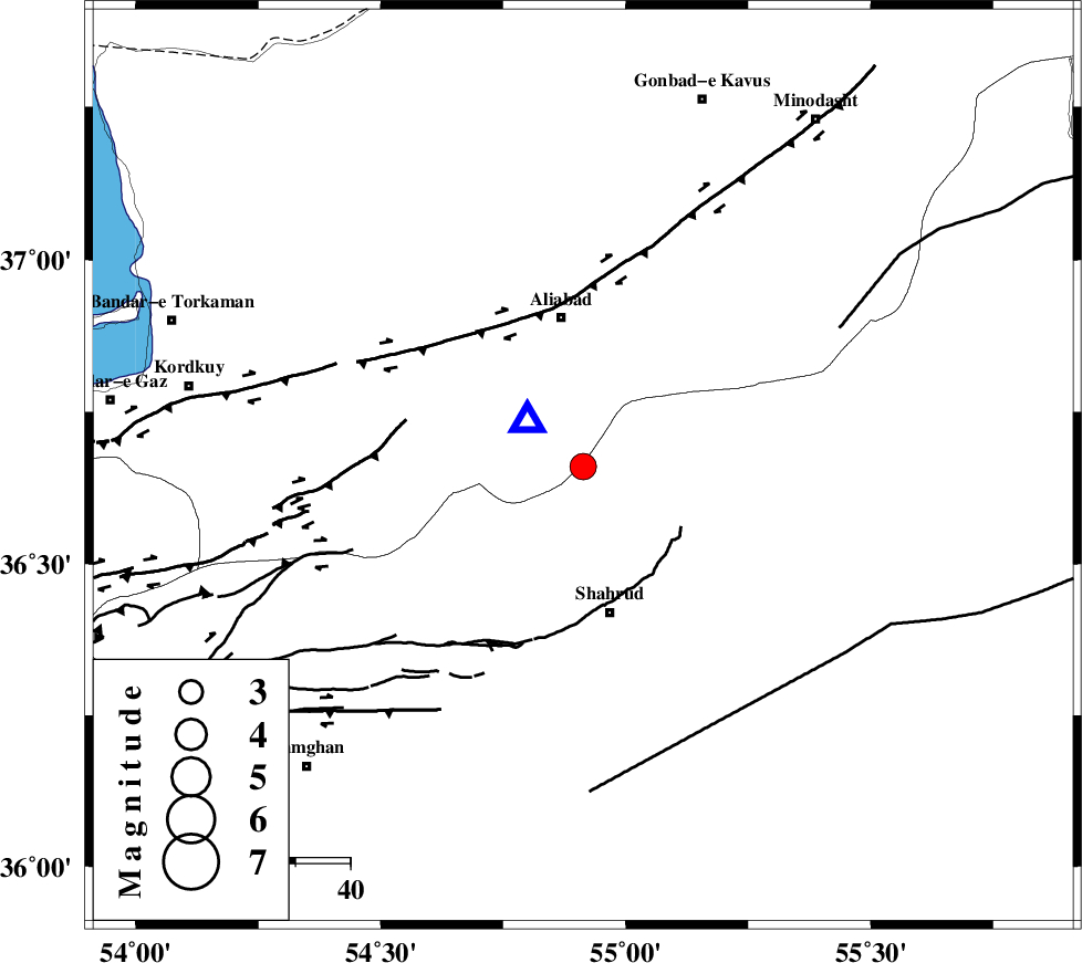
| Location | Lat:36.66 Lon: 54.913 |
| Region | Semnan Province, 28 km South of Ali Abad |
Nearest Cities |
|
| 17 km North West of Qaleh-ye nokharqan, Semnan Province | |
| 22 km North of Bastam, Semnan Province | |
| 27 km North of Shahrud, Semnan Province | |
| 28 km South of Ali Abad, Golestan Province | |
| 31 km North East of Majen, Semnan Province | |
| Depth | 12 km |
| Agency | |
Faults within 150 km: |
|
| SHAVAR_F (Length: 87 km) , Distance to epicenter: 10 km | |
| ASTANEH_F (Length: 72 km) , Distance to epicenter: 34 km | |
| KHAZAR_F (Length: 523 km) , Distance to epicenter: 39 km | |
| Number of Phases | 9 |
| RMS | 0.5 |
| Number of Stations | 9 |
| Error in Latitude | >5.3 km |
| Error in Longitude | 5.3 km |
| Error in Depth | 757.5 km |
Download waveform in seisan format
to download seisan software Click here
to access information about IIEES stations Click here
Amplitude | ||||||||
| UID | Agency | Station | Component | Amplitude | Period | Arrival Time | Proccessing Time | Signal Clip |
| 198721 | IIEES SC | TABS | Z | 0.06 | 1 | 2025-07-19 22:14:15 | 2025-07-20 06:26:00 | n |
| 198722 | IIEES SC | GHVR | Z | 0.2 | 1 | 2025-07-19 22:14:18 | 2025-07-20 06:26:00 | n |
| 198723 | IIEES SC | NASN | Z | 0.04 | 1 | 2025-07-19 22:14:24 | 2025-07-20 06:26:00 | n |
| 198724 | IIEES SC | SHRT | Z | 0.03 | 1 | 2025-07-19 22:14:40 | 2025-07-20 06:26:00 | n |
Phase | ||||||||||||
| Agency | Station | Component | Phase Type | Phase Quality | First Motion | Observed Arrival Time | Time Residual | Loc. Flag | Input Weight | Distance | Azimuth | |
| IIEES SC | BJRD | Z | EPn | E | 2025-07-19 22:13:57 | -0.2 | y | 0 | 250 | 63 | ||
| IIEES SC | DAMV | Z | EPn | E | 2025-07-19 22:13:48 | -14.7 | n | 4 | 288 | 247 | ||
| IIEES SC | TABS | Z | EPn | E | 2025-07-19 22:14:15 | 0.2 | y | 0 | 390 | 149 | ||
| IIEES SC | GHVR | Z | EPn | E | 2025-07-19 22:14:18 | 0.9 | y | 0 | 411 | 234 | ||
| IIEES SC | KAGH | Z | EPn | E | 2025-07-19 22:14:23 | 0.2 | y | 0 | 451 | 86 | ||
| IIEES SC | NASN | Z | EPn | E | 2025-07-19 22:14:24 | -0.6 | y | 0 | 470 | 204 | ||
| IIEES SC | YZKH | Z | EPn | E | 2025-07-19 22:14:07 | -18.8 | n | 4 | 475 | 184 | ||
| IIEES SC | SHRT | Z | EPn | E | 2025-07-19 22:14:40 | -0.5 | y | 0 | 593 | 124 | ||
| IIEES SC | BSRN | Z | EPn | E | 2025-07-19 22:14:32 | -14.6 | n | 4 | 649 | 143 | ||

 IIEES All Rights Reserved