
Magnitude |
4 |
| Date & Time (UTC) | 2025-07-28 10:53:18.7 |
| Date & Time (Local) | 1404/5/6 14:23:18.7 |
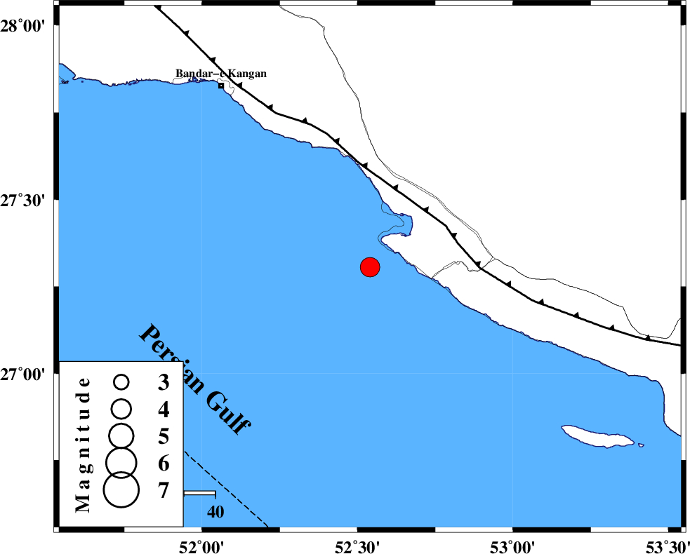
| Location | Lat:27.306 Lon: 52.54 |
| Region | Persian Gulf, 44 km South-West of Mehr |
Nearest Cities |
|
| 20 km South of Bandar-e asaluyeh, Bushehr Province | |
| 25 km West of Chah-e mobarak, Bushehr Province | |
| 41 km South West of Ardavan-e olia, Fars Province | |
| 41 km South West of Gallehdar, Fars Province | |
| 44 km South West of Mehr, Fars Province | |
| Depth | 21 km |
| Agency | |
Faults within 150 km: |
|
| MFF3 (Length: 292 km) , Distance to epicenter: 27 km | |
| BORAZJAN_F (Length: 168 km) , Distance to epicenter: 120 km | |
| QIR_F (Length: 130 km) , Distance to epicenter: 129 km | |
| Number of Phases | 9 |
| RMS | 0.4 |
| Number of Stations | 9 |
| Error in Latitude | >3.2 km |
| Error in Longitude | 3.2 km |
| Error in Depth | 7.7 km |
Download waveform in seisan format
to download seisan software Click here
to access information about IIEES stations Click here
Amplitude | ||||||||
| UID | Agency | Station | Component | Amplitude | Period | Arrival Time | Proccessing Time | Signal Clip |
| 198739 | IIEES SC | UOSS | Z | 0.2 | 1 | 2025-07-28 10:54:22 | 2025-07-31 08:38:00 | n |
| 198740 | IIEES SC | GHVR | Z | 0.07 | 1 | 2025-07-28 10:55:05 | 2025-07-31 08:38:00 | n |
| 198741 | IIEES SC | IRSR | Z | 0.02 | 1 | 2025-07-28 10:55:08 | 2025-07-31 08:38:00 | n |
Phase | ||||||||||||
| Agency | Station | Component | Phase Type | Phase Quality | First Motion | Observed Arrival Time | Time Residual | Loc. Flag | Input Weight | Distance | Azimuth | |
| IIEES SC | GHIR | Z | EPg | E | 2025-07-28 10:53:38 | 0.1 | y | 0 | 117 | 22 | ||
| IIEES SC | UOSS | Z | EPn | E | 2025-07-28 10:54:22 | 0.8 | y | 0 | 450 | 126 | ||
| IIEES SC | KRBR | Z | EPn | E | 2025-07-28 10:54:24 | -4.4 | n | 4 | 508 | 54 | ||
| IIEES SC | NASN | Z | EPn | E | 2025-07-28 10:54:34 | -6.9 | n | 4 | 610 | 2 | ||
| IIEES SC | GHVR | Z | EPn | E | 2025-07-28 10:55:05 | 0.2 | y | 0 | 805 | 351 | ||
| IIEES SC | CHBR | Z | EPn | E | 2025-07-28 10:55:06 | -0.7 | y | 0 | 814 | 103 | ||
| IIEES SC | RAYN | Z | EPn | E | 2025-07-28 10:55:07 | -0.1 | y | 0 | 823 | 239 | ||
| IIEES SC | IRSR | Z | EPn | E | 2025-07-28 10:55:08 | 0.2 | y | 0 | 826 | 93 | ||
| IIEES SC | TABS | Z | EPn | E | 2025-07-28 10:55:07 | -0.9 | y | 0 | 829 | 32 | ||