
Magnitude |
3.9 |
| Date & Time (UTC) | 2025-08-05 02:25:43.6 |
| Date & Time (Local) | 1404/5/14 05:55:43.6 |
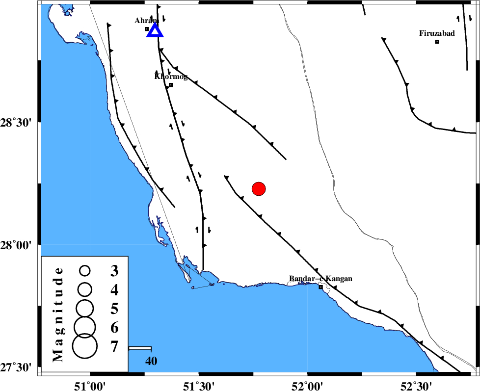
| Location | Lat:28.228 Lon: 51.775 |
| Region | Bushehr Province, 53 km North-West of Bandar-e kangan |
Nearest Cities |
|
| 17 km North of Abdan, Bushehr Province | |
| 18 km South of Shanbeh, Bushehr Province | |
| 26 km North East of Abkesh, Bushehr Province | |
| 28 km South East of Kaki, Bushehr Province | |
| 33 km South East of Baduleh, Bushehr Province | |
| Depth | 12 km |
| Agency | |
Faults within 150 km: |
|
| MFF3 (Length: 292 km) , Distance to epicenter: 11 km | |
| MFF5 (Length: 74 km) , Distance to epicenter: 18 km | |
| BORAZJAN_F (Length: 168 km) , Distance to epicenter: 26 km | |
| Number of Phases | 9 |
| RMS | 0.7 |
| Number of Stations | 9 |
| Error in Latitude | >4.4 km |
| Error in Longitude | 4.4 km |
| Error in Depth | 22.5 km |
Download waveform in seisan format
to download seisan software Click here
to access information about IIEES stations Click here
Amplitude | ||||||||
| UID | Agency | Station | Component | Amplitude | Period | Arrival Time | Proccessing Time | Signal Clip |
| 198771 | IIEES SC | NASN | Z | 0.1 | 1 | 2025-08-05 02:26:54 | 2025-08-05 10:08:00 | n |
| 198772 | IIEES SC | UOSS | Z | 0.09 | 1 | 2025-08-05 02:27:02 | 2025-08-05 10:08:00 | n |
| 198773 | IIEES SC | GHVR | Z | 0.1 | 1 | 2025-08-05 02:27:18 | 2025-08-05 10:08:00 | n |
| 198774 | IIEES SC | TABS | Z | 0.02 | 1 | 2025-08-05 02:27:28 | 2025-08-05 10:08:00 | n |
Phase | ||||||||||||
| Agency | Station | Component | Phase Type | Phase Quality | First Motion | Observed Arrival Time | Time Residual | Loc. Flag | Input Weight | Distance | Azimuth | |
| IIEES SC | GHIR | Z | EPg | E | 2025-08-05 02:26:04 | 1.1 | y | 0 | 119 | 87 | ||
| IIEES SC | BSR2 | Z | EPn | E | 2025-08-05 02:26:49 | 0.2 | y | 0 | 464 | 300 | ||
| IIEES SC | NASN | Z | EPn | E | 2025-08-05 02:26:54 | -1 | y | 0 | 516 | 11 | ||
| IIEES SC | KRBR | Z | EPn | E | 2025-08-05 02:26:51 | -5.3 | n | 4 | 523 | 68 | ||
| IIEES SC | YZKH | Z | EPn | E | 2025-08-05 02:26:29 | -28.7 | n | 4 | 535 | 30 | ||
| IIEES SC | UOSS | Z | EPn | E | 2025-08-05 02:27:02 | -0.5 | y | 0 | 572 | 129 | ||
| IIEES SC | GHVR | Z | EPn | E | 2025-08-05 02:27:18 | 0.8 | y | 0 | 695 | 356 | ||
| IIEES SC | TABS | Z | EPn | E | 2025-08-05 02:27:28 | -0.6 | y | 0 | 789 | 40 | ||
| IIEES SC | BSRN | Z | EPn | E | 2025-08-05 02:27:17 | -16.4 | n | 4 | 821 | 60 | ||