
Magnitude |
3.1 |
| Date & Time (UTC) | 2025-08-07 05:51:34.8 |
| Date & Time (Local) | 1404/5/16 09:21:34.8 |
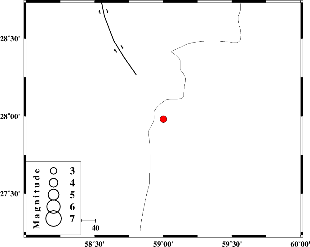
| Location | Lat:27.981 Lon: 59.001 |
| Region | Sistan va Baloochestan Province, 128 km -East of Kahnuj |
Nearest Cities |
|
| 48 km East of Borj-e abbasabad, Kerman Province | |
| 72 km North West of Kalemursi, Sistan va Baloochestan Province | |
| 81 km South of Hoseynabad, Kerman Province | |
| 83 km South East of Mohammadabad-e gonbaki, Kerman Province | |
| 91 km South East of Mardehak, Kerman Province | |
| Depth | 12 km |
| Agency | |
Faults within 150 km: |
|
| BAM_F (Length: 118 km) , Distance to epicenter: 37 km | |
| JIROFT_F (Length: 144 km) , Distance to epicenter: 117 km | |
| S_JAZMURIAN_F (Length: 91 km) , Distance to epicenter: 121 km | |
| Number of Phases | 8 |
| RMS | 0.4 |
| Number of Stations | 8 |
| Error in Latitude | >2.6 km |
| Error in Longitude | 2.6 km |
| Error in Depth | 10.9 km |
Download waveform in seisan format
to download seisan software Click here
to access information about IIEES stations Click here
Amplitude | ||||||||
| UID | Agency | Station | Component | Amplitude | Period | Arrival Time | Proccessing Time | Signal Clip |
| 198775 | IIEES SC | KRBR | Z | 0.07 | 1 | 2025-08-07 05:52:21 | 2025-08-09 04:24:00 | n |
| 198776 | IIEES SC | UOSS | Z | 0.08 | 1 | 2025-08-07 05:52:37 | 2025-08-09 04:24:00 | n |
| 198777 | IIEES SC | SHRT | Z | 0.01 | 1 | 2025-08-07 05:53:03 | 2025-08-09 04:24:00 | n |
| 198778 | IIEES SC | TABS | Z | 0.008 | 1 | 2025-08-07 05:53:03 | 2025-08-09 04:24:00 | n |
Phase | ||||||||||||
| Agency | Station | Component | Phase Type | Phase Quality | First Motion | Observed Arrival Time | Time Residual | Loc. Flag | Input Weight | Distance | Azimuth | |
| IIEES SC | IRSR | Z | EPn | E | 2025-08-07 05:52:09 | 0.4 | y | 0 | 215 | 121 | ||
| IIEES SC | IRSR | Z | ES | E | 2025-08-07 05:52:34 | -0.2 | y | 0 | 215 | 121 | ||
| IIEES SC | CHBR | Z | EPn | E | 2025-08-07 05:52:19 | -0.4 | y | 0 | 303 | 151 | ||
| IIEES SC | KRBR | Z | EPn | E | 2025-08-07 05:52:21 | -0.5 | y | 0 | 311 | 315 | ||
| IIEES SC | UOSS | Z | EPn | E | 2025-08-07 05:52:37 | 0 | y | 0 | 437 | 220 | ||
| IIEES SC | GHIR | Z | EPn | E | 2025-08-07 05:52:56 | 0.5 | y | 0 | 592 | 273 | ||
| IIEES SC | SHRT | Z | EPn | E | 2025-08-07 05:53:03 | 0.8 | y | 0 | 640 | 11 | ||
| IIEES SC | TABS | Z | EPn | E | 2025-08-07 05:53:03 | -0.3 | y | 0 | 654 | 344 | ||