
Magnitude |
3.5 |
| Date & Time (UTC) | 2025-08-05 15:15:18.7 |
| Date & Time (Local) | 1404/5/14 18:45:18.7 |
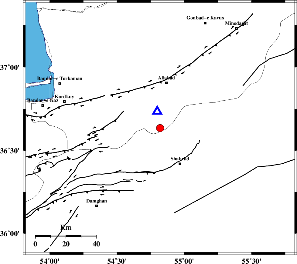
| Location | Lat:36.635 Lon: 54.82 |
| Region | Golestan Province, 30 km South of Ali Abad |
Nearest Cities |
|
| 23 km North East of Majen, Semnan Province | |
| 24 km North West of Bastam, Semnan Province | |
| 26 km North West of Qaleh-ye nokharqan, Semnan Province | |
| 27 km North West of Shahrud, Semnan Province | |
| 30 km South of Ali Abad, Golestan Province | |
| Depth | 7 km |
| Agency | |
Faults within 150 km: |
|
| SHAVAR_F (Length: 87 km) , Distance to epicenter: 9 km | |
| ASTANEH_F (Length: 72 km) , Distance to epicenter: 25 km | |
| KHAZAR_F (Length: 523 km) , Distance to epicenter: 37 km | |
| Number of Phases | 10 |
| RMS | 0.3 |
| Number of Stations | 10 |
| Error in Latitude | >3.7 km |
| Error in Longitude | 3.7 km |
| Error in Depth | 5.3 km |
Download waveform in seisan format
to download seisan software Click here
to access information about IIEES stations Click here
Amplitude | ||||||||
| UID | Agency | Station | Component | Amplitude | Period | Arrival Time | Proccessing Time | Signal Clip |
| 198795 | IIEES SC | TABS | Z | 0.07 | 1 | 2025-08-05 15:16:16 | 2025-08-09 07:43:00 | n |
| 198796 | IIEES SC | NASN | Z | 0.08 | 1 | 2025-08-05 15:16:24 | 2025-08-09 07:43:00 | n |
| 198797 | IIEES SC | SHRT | Z | 0.04 | 1 | 2025-08-05 15:16:41 | 2025-08-09 07:43:00 | n |
Phase | ||||||||||||
| Agency | Station | Component | Phase Type | Phase Quality | First Motion | Observed Arrival Time | Time Residual | Loc. Flag | Input Weight | Distance | Azimuth | |
| IIEES SC | ABGH | Z | EPg | E | 2025-08-05 15:15:21 | -0.1 | y | 0 | 11 | 350 | ||
| IIEES SC | SHRO | Z | EPg | E | 2025-08-05 15:15:13 | -27.1 | n | 4 | 128 | 123 | ||
| IIEES SC | BJRD | Z | EPn | E | 2025-08-05 15:15:59 | 0.2 | y | 0 | 259 | 63 | ||
| IIEES SC | TABS | Z | EPn | E | 2025-08-05 15:16:16 | 0.3 | y | 0 | 392 | 148 | ||
| IIEES SC | GHVR | Z | EPn | E | 2025-08-05 15:16:17 | 0.5 | y | 0 | 403 | 234 | ||
| IIEES SC | KAGH | Z | EPn | E | 2025-08-05 15:16:24 | -0.4 | y | 0 | 460 | 86 | ||
| IIEES SC | NASN | Z | EPn | E | 2025-08-05 15:16:24 | -0.7 | y | 0 | 464 | 203 | ||
| IIEES SC | YZKH | Z | EPn | E | 2025-08-05 15:15:55 | -30.3 | n | 4 | 471 | 183 | ||
| IIEES SC | SHRT | Z | EPn | E | 2025-08-05 15:16:41 | 0.1 | y | 0 | 599 | 124 | ||
| IIEES SC | BSRN | Z | EPn | E | 2025-08-05 15:16:35 | -13 | n | 4 | 652 | 143 | ||

 IIEES All Rights Reserved