
Magnitude |
4.7 |
| Date & Time (UTC) | 2025-09-14 04:43:46.5 |
| Date & Time (Local) | 1404/6/23 08:13:46.5 |
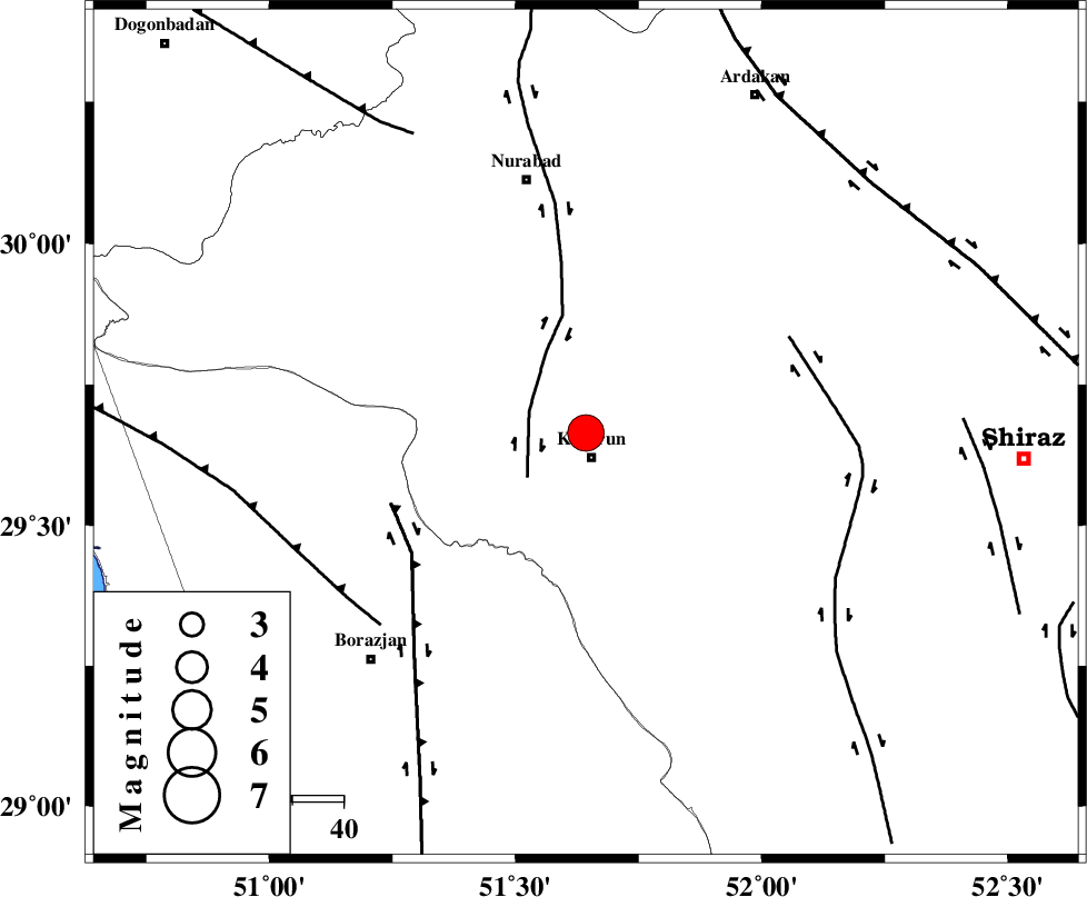
| Location | Lat:29.664 Lon: 51.643 |
| Region | Fars Province, 5 km of Kazerun |
Nearest Cities |
|
| 5 km North of Kazerun, Fars Province | |
| 7 km of Deris, Fars Province | |
| 12 km North of Mehranjan, Fars Province | |
| 15 km South of Seyyed hasan, Fars Province | |
| 16 km South of Nodan, Fars Province | |
| Depth | 12 km |
| Agency | |
Faults within 150 km: |
|
| KAZERUN_F (Length: 96 km) , Distance to epicenter: 12 km | |
| BORAZJAN_F (Length: 168 km) , Distance to epicenter: 41 km | |
| KAREBASS_F (Length: 98 km) , Distance to epicenter: 44 km | |
| Number of Phases | 12 |
| RMS | 0.6 |
| Number of Stations | 12 |
| Error in Latitude | >5 km |
| Error in Longitude | 5 km |
| Error in Depth | 19.5 km |
Download waveform in seisan format
to download seisan software Click here
to access information about IIEES stations Click here
Amplitude | ||||||||
| UID | Agency | Station | Component | Amplitude | Period | Arrival Time | Proccessing Time | Signal Clip |
| 199110 | IIEES SC | ASAO | Z | 1 | 1 | 2025-09-14 04:45:04 | 2025-09-15 07:52:00 | n |
| 199111 | IIEES SC | TABS | Z | 0.1 | 1 | 2025-09-14 04:45:19 | 2025-09-15 07:52:00 | n |
| 199112 | IIEES SC | UOSS | Z | 0.5 | 1 | 2025-09-14 04:45:19 | 2025-09-15 07:52:00 | n |
Phase | ||||||||||||
| Agency | Station | Component | Phase Type | Phase Quality | First Motion | Observed Arrival Time | Time Residual | Loc. Flag | Input Weight | Distance | Azimuth | |
| IIEES SC | GHIR | Z | EPn | E | 2025-09-14 04:44:19 | 0.6 | y | 0 | 201 | 139 | ||
| IIEES SC | YZKH | Z | EPn | E | 2025-09-14 04:44:19 | -26.1 | n | 4 | 413 | 43 | ||
| IIEES SC | KRBR | Z | EPn | E | 2025-09-14 04:44:55 | -0.8 | y | 0 | 496 | 86 | ||
| IIEES SC | ASAO | Z | EPn | E | 2025-09-14 04:45:04 | -0.2 | y | 0 | 563 | 344 | ||
| IIEES SC | DAMV | Z | EPn | E | 2025-09-14 04:45:06 | -10.8 | n | 4 | 662 | 3 | ||
| IIEES SC | TABS | Z | EPn | E | 2025-09-14 04:45:19 | 0.7 | y | 0 | 682 | 50 | ||
| IIEES SC | UOSS | Z | EPn | E | 2025-09-14 04:45:19 | -0.9 | y | 0 | 691 | 139 | ||
| IIEES SC | BSRN | Z | EPn | E | 2025-09-14 04:45:16 | -12.6 | n | 4 | 760 | 70 | ||
| IIEES SC | SHRO | Z | EPn | E | 2025-09-14 04:45:31 | -3.8 | n | 4 | 814 | 30 | ||
| IIEES SC | ABGH | Z | EPn | E | 2025-09-14 04:45:39 | 0.6 | y | 0 | 838 | 21 | ||
| IIEES SC | ZHSF | Z | EPn | E | 2025-09-14 04:45:44 | 0.6 | y | 0 | 884 | 90 | ||
| IIEES SC | SHRT | Z | EPn | E | 2025-09-14 04:45:49 | -0.6 | y | 0 | 932 | 62 | ||