
Magnitude |
3.2 |
| Date & Time (UTC) | 2025-09-14 08:43:29.0 |
| Date & Time (Local) | 1404/6/23 12:13:29.0 |
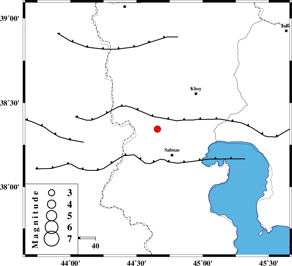
| Location | Lat:38.344 Lon: 44.657 |
| Region | Azarbaijan Gharbi Province, 20 km North-West of Salmas |
Nearest Cities |
|
| 9 km North of Saylab, Azarbaijan Gharbi Province | |
| 20 km North West of Salmas, Azarbaijan Gharbi Province | |
| 21 km North of Tazehshahr, Azarbaijan Gharbi Province | |
| 26 km South East of Gatur, Azarbaijan Gharbi Province | |
| 26 km South West of Beyk sofla, Azarbaijan Gharbi Province | |
| Depth | 12 km |
| Agency | |
Faults within 150 km: |
|
| SALMAS (Length: 20 km) , Distance to epicenter: 15 km | |
| N_TABRIZ_F3 (Length: 66 km) , Distance to epicenter: 20 km | |
| KHOY (Length: 100 km) , Distance to epicenter: 33 km | |
| Number of Phases | 5 |
| RMS | 0.3 |
| Number of Stations | 5 |
| Error in Latitude | >4 km |
| Error in Longitude | 4 km |
| Error in Depth | 21.7 km |
Download waveform in seisan format
to download seisan software Click here
to access information about IIEES stations Click here
Amplitude | ||||||||
| UID | Agency | Station | Component | Amplitude | Period | Arrival Time | Proccessing Time | Signal Clip |
| 199124 | IIEES SC | GURO | Z | 0.2 | 1 | 2025-09-14 08:44:05 | 2025-09-15 09:04:00 | n |
| 199125 | IIEES SC | SRSL | Z | 0.4 | 1 | 2025-09-14 08:44:07 | 2025-09-15 09:04:00 | n |
Phase | ||||||||||||
| Agency | Station | Component | Phase Type | Phase Quality | First Motion | Observed Arrival Time | Time Residual | Loc. Flag | Input Weight | Distance | Azimuth | |
| IIEES SC | MAKU | Z | EPg | E | 2025-09-14 08:43:48 | 0.6 | y | 0 | 112 | 1 | ||
| IIEES SC | GNI | Z | EPn | E | 2025-09-14 08:44:00 | -1.1 | y | 0 | 200 | 2 | ||
| IIEES SC | GNI | Z | ES | E | 2025-09-14 08:44:25 | 0.1 | y | 0 | 200 | 2 | ||
| IIEES SC | GURO | Z | EPn | E | 2025-09-14 08:44:05 | 0 | y | 0 | 230 | 276 | ||
| IIEES SC | SRSL | Z | EPn | E | 2025-09-14 08:44:07 | 0 | y | 0 | 246 | 164 | ||