
Magnitude |
3.7 |
| Date & Time (UTC) | 2025-09-14 04:18:22.1 |
| Date & Time (Local) | 1404/6/23 07:48:22.1 |
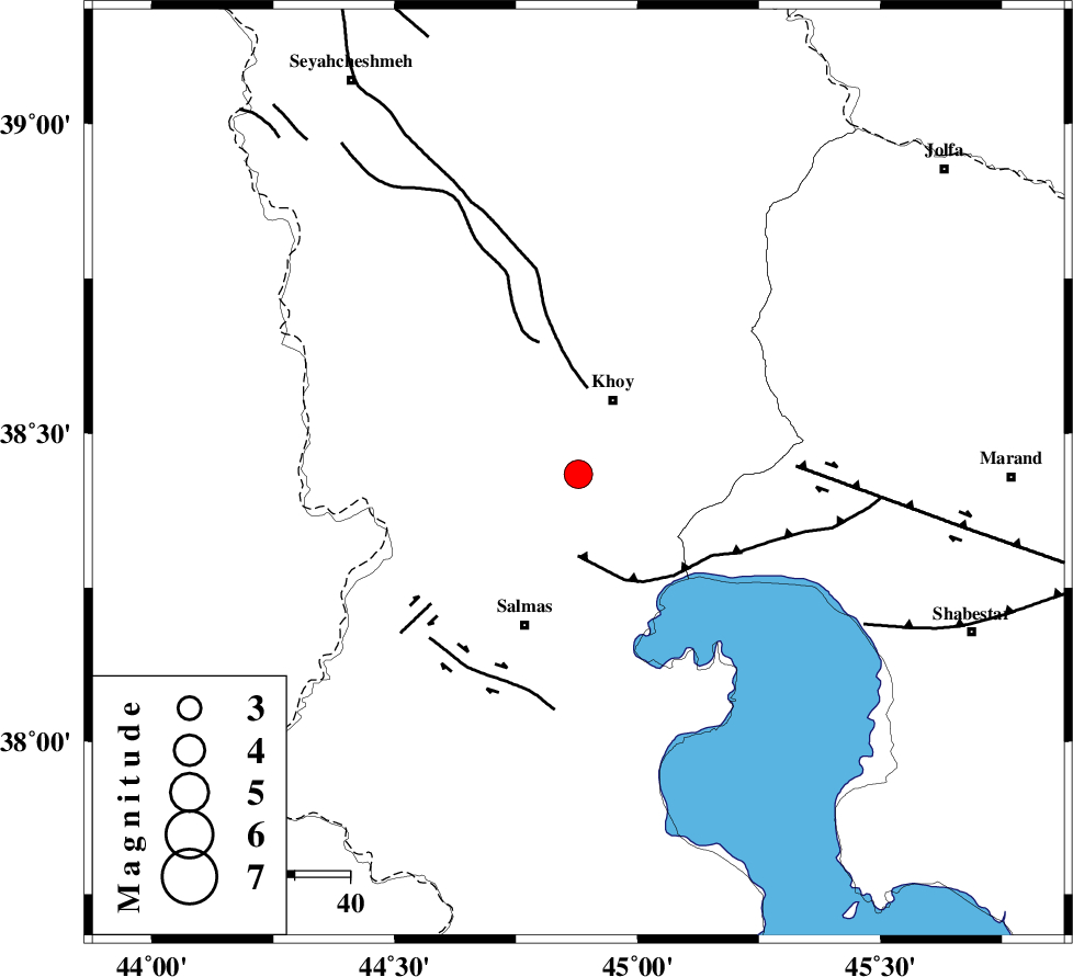
| Location | Lat:38.434 Lon: 44.878 |
| Region | Azarbaijan Gharbi Province, 15 km South of Khoy |
Nearest Cities |
|
| 4 km of Quruq, Azarbaijan Gharbi Province | |
| 14 km West of Dizaj diz, Azarbaijan Gharbi Province | |
| 14 km South of Beyk sofla, Azarbaijan Gharbi Province | |
| 15 km South of Khoy, Azarbaijan Gharbi Province | |
| 17 km North East of Saylab, Azarbaijan Gharbi Province | |
| Depth | 12 km |
| Agency | |
Faults within 150 km: |
|
| N_TABRIZ_F3 (Length: 66 km) , Distance to epicenter: 15 km | |
| KHOY (Length: 100 km) , Distance to epicenter: 16 km | |
| SALMAS (Length: 20 km) , Distance to epicenter: 35 km | |
| Number of Phases | 5 |
| RMS | 0.2 |
| Number of Stations | 5 |
| Error in Latitude | >4.1 km |
| Error in Longitude | 4.1 km |
| Error in Depth | 24.9 km |
Download waveform in seisan format
to download seisan software Click here
to access information about IIEES stations Click here
Amplitude | ||||||||
| UID | Agency | Station | Component | Amplitude | Period | Arrival Time | Proccessing Time | Signal Clip |
| 199136 | IIEES SC | GURO | Z | 0.6 | 1 | 2025-09-14 04:19:01 | 2025-09-16 08:28:00 | n |
| 199137 | IIEES SC | SRSL | Z | 1 | 1 | 2025-09-14 04:19:01 | 2025-09-16 08:28:00 | n |
| 199138 | IIEES SC | ASAO | Z | 0.05 | 1 | 2025-09-14 04:19:48 | 2025-09-16 08:28:00 | n |
Phase | ||||||||||||
| Agency | Station | Component | Phase Type | Phase Quality | First Motion | Observed Arrival Time | Time Residual | Loc. Flag | Input Weight | Distance | Azimuth | |
| IIEES SC | GNI | Z | EPg | E | 2025-09-14 04:18:53 | 0 | y | 0 | 191 | 356 | ||
| IIEES SC | GURO | Z | EPn | E | 2025-09-14 04:19:01 | 0 | y | 0 | 249 | 273 | ||
| IIEES SC | SRSL | Z | EPn | E | 2025-09-14 04:19:01 | -0.1 | y | 0 | 252 | 169 | ||
| IIEES SC | ASAO | Z | EPn | E | 2025-09-14 04:19:48 | -0.6 | y | 0 | 632 | 133 | ||
| IIEES SC | ABGH | Z | EPn | E | 2025-09-14 04:20:21 | 0.5 | y | 0 | 896 | 102 | ||