
Magnitude |
3 |
| Date & Time (UTC) | 2025-09-16 17:54:40.3 |
| Date & Time (Local) | 1404/6/25 21:24:40.3 |
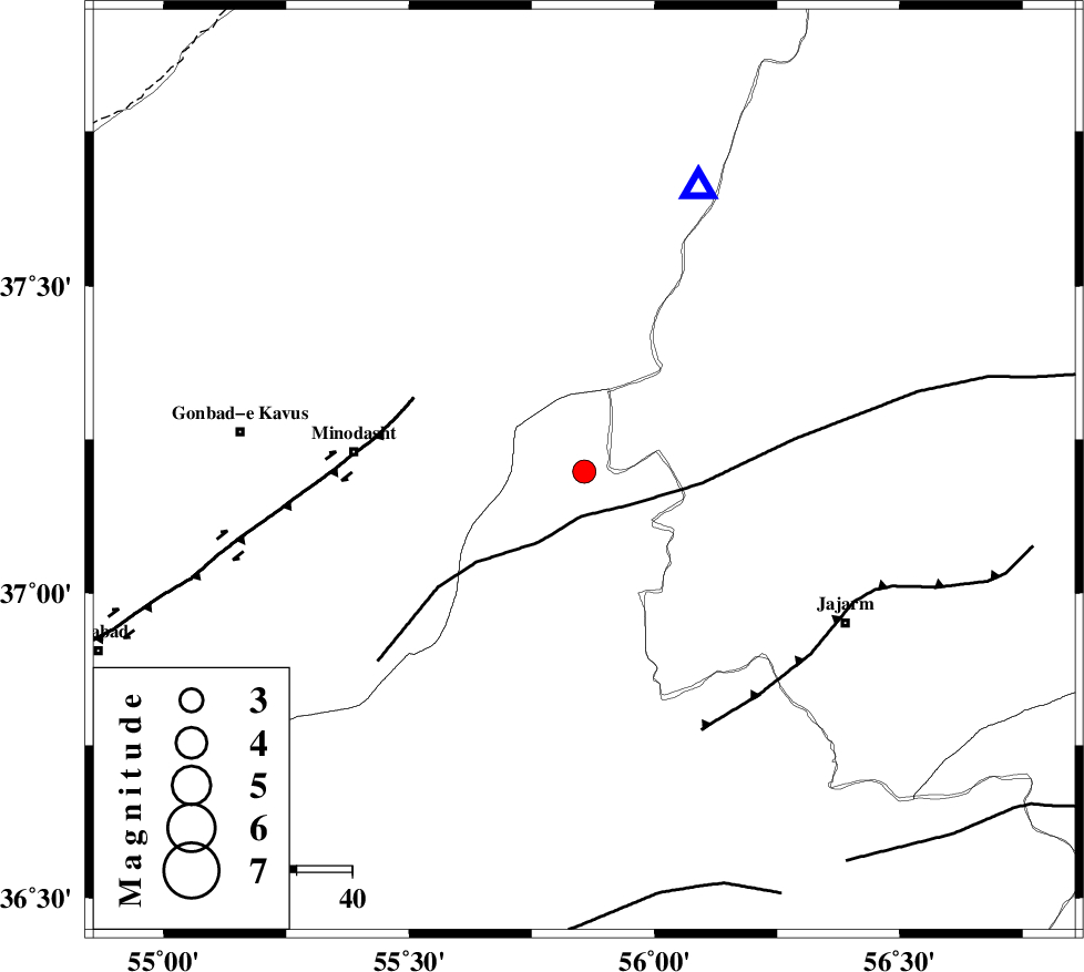
| Location | Lat:37.198 Lon: 55.857 |
| Region | Semnan Province, 42 km -East of Minodasht |
Nearest Cities |
|
| 17 km North East of Rezvan, Semnan Province | |
| 19 km North of Nardin, Semnan Province | |
| 23 km East of Farsian, Golestan Province | |
| 26 km North East of Duzin, Golestan Province | |
| 28 km South East of Aq qamish, Golestan Province | |
| Depth | 12 km |
| Agency | |
Faults within 150 km: |
|
| ROBATE_QARABIL_F (Length: 168 km) , Distance to epicenter: 8 km | |
| JAJARAM_F (Length: 77 km) , Distance to epicenter: 51 km | |
| SHAVAR_F (Length: 87 km) , Distance to epicenter: 74 km | |
| Number of Phases | 9 |
| RMS | 0.7 |
| Number of Stations | 9 |
| Error in Latitude | >2.5 km |
| Error in Longitude | 2.5 km |
| Error in Depth | 9.9 km |
Download waveform in seisan format
to download seisan software Click here
to access information about IIEES stations Click here
Amplitude | ||||||||
| UID | Agency | Station | Component | Amplitude | Period | Arrival Time | Proccessing Time | Signal Clip |
| 199166 | IIEES SC | TABS | Z | 0.02 | 1 | 2025-09-16 17:55:40 | 2025-09-17 07:38:00 | n |
| 199167 | IIEES SC | SHRT | Z | 0.01 | 1 | 2025-09-16 17:55:58 | 2025-09-17 07:38:00 | n |
| 199168 | IIEES SC | ASAO | Z | 0.01 | 1 | 2025-09-16 17:56:03 | 2025-09-17 07:38:00 | n |
Phase | ||||||||||||
| Agency | Station | Component | Phase Type | Phase Quality | First Motion | Observed Arrival Time | Time Residual | Loc. Flag | Input Weight | Distance | Azimuth | |
| IIEES SC | ABGH | Z | EPg | E | 2025-09-16 17:54:58 | -0.1 | y | 0 | 107 | 241 | ||
| IIEES SC | SHRO | Z | EPg | E | 2025-09-16 17:55:01 | -1.1 | y | 0 | 133 | 174 | ||
| IIEES SC | SHRO | Z | ESg | E | 2025-09-16 17:55:18 | 0 | y | 0 | 133 | 174 | ||
| IIEES SC | BJRD | Z | EPg | E | 2025-09-16 17:55:03 | -1 | y | 0 | 148 | 68 | ||
| IIEES SC | KAGH | Z | EPn | E | 2025-09-16 17:55:34 | 0.8 | y | 0 | 366 | 95 | ||
| IIEES SC | TABS | Z | EPn | E | 2025-09-16 17:55:40 | 0.8 | y | 0 | 410 | 164 | ||
| IIEES SC | NASN | Z | EPn | E | 2025-09-16 17:55:58 | 0.2 | y | 0 | 562 | 210 | ||
| IIEES SC | SHRT | Z | EPn | E | 2025-09-16 17:55:58 | 0.7 | y | 0 | 564 | 134 | ||
| IIEES SC | ASAO | Z | EPn | E | 2025-09-16 17:56:03 | -0.4 | y | 0 | 603 | 241 | ||