
Magnitude |
3.7 |
| Date & Time (UTC) | 2025-07-28 11:24:17.4 |
| Date & Time (Local) | 1404/5/6 14:54:17.4 |
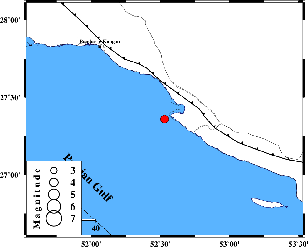
| Location | Lat:27.36 Lon: 52.53 |
| Region | Persian Gulf, 41 km South-West of Mehr |
Nearest Cities |
|
| 15 km South of Bandar-e asaluyeh, Bushehr Province | |
| 26 km West of Chah-e mobarak, Bushehr Province | |
| 36 km South West of Gallehdar, Fars Province | |
| 37 km South West of Ardavan-e olia, Fars Province | |
| 39 km South East of Bandar-e taheri, Bushehr Province | |
| Depth | 12 km |
| Agency | |
Faults within 150 km: |
|
| MFF3 (Length: 292 km) , Distance to epicenter: 26 km | |
| BORAZJAN_F (Length: 168 km) , Distance to epicenter: 116 km | |
| QIR_F (Length: 130 km) , Distance to epicenter: 123 km | |
| Number of Phases | 9 |
| RMS | 0.2 |
| Number of Stations | 9 |
| Error in Latitude | >1.2 km |
| Error in Longitude | 1.2 km |
| Error in Depth | 7.5 km |
Download waveform in seisan format
to download seisan software Click here
to access information about IIEES stations Click here
Amplitude | ||||||||
| UID | Agency | Station | Component | Amplitude | Period | Arrival Time | Proccessing Time | Signal Clip |
| 199282 | IIEES SC | UOSS | Z | 0.2 | 1 | 2025-07-28 11:25:21 | 2025-09-23 08:49:00 | n |
| 199283 | IIEES SC | NASN | Z | 0.06 | 1 | 2025-07-28 11:25:40 | 2025-09-23 08:49:00 | n |
| 199284 | IIEES SC | TABS | Z | 0.02 | 1 | 2025-07-28 11:26:07 | 2025-09-23 08:49:00 | n |
| 199285 | IIEES SC | IRSR | Z | 0.01 | 1 | 2025-07-28 11:26:08 | 2025-09-23 08:49:00 | n |
Phase | ||||||||||||
| Agency | Station | Component | Phase Type | Phase Quality | First Motion | Observed Arrival Time | Time Residual | Loc. Flag | Input Weight | Distance | Azimuth | |
| IIEES SC | GHIR | Z | EPg | E | 2025-07-28 11:24:36 | 0.1 | y | 0 | 112 | 24 | ||
| IIEES SC | UOSS | Z | EPn | E | 2025-07-28 11:25:21 | -0.2 | y | 0 | 454 | 126 | ||
| IIEES SC | KRBR | Z | EPn | E | 2025-07-28 11:25:25 | -3.2 | n | 4 | 505 | 55 | ||
| IIEES SC | NASN | Z | EPn | E | 2025-07-28 11:25:40 | 0.2 | y | 0 | 604 | 3 | ||
| IIEES SC | GHVR | Z | EPn | E | 2025-07-28 11:26:04 | -0.2 | y | 0 | 799 | 351 | ||
| IIEES SC | TABS | Z | EPn | E | 2025-07-28 11:26:07 | 0 | y | 0 | 825 | 32 | ||
| IIEES SC | RAYN | Z | EPn | E | 2025-07-28 11:26:07 | 0.1 | y | 0 | 825 | 239 | ||
| IIEES SC | IRSR | Z | EPn | E | 2025-07-28 11:26:08 | 0.3 | y | 0 | 827 | 93 | ||
| IIEES SC | SRSL | Z | EPn | E | 2025-07-28 11:26:51 | -2 | n | 4 | 1190 | 326 | ||