
Magnitude |
3.3 |
| Date & Time (UTC) | 2025-07-27 00:52:49.8 |
| Date & Time (Local) | 1404/5/5 04:22:49.8 |
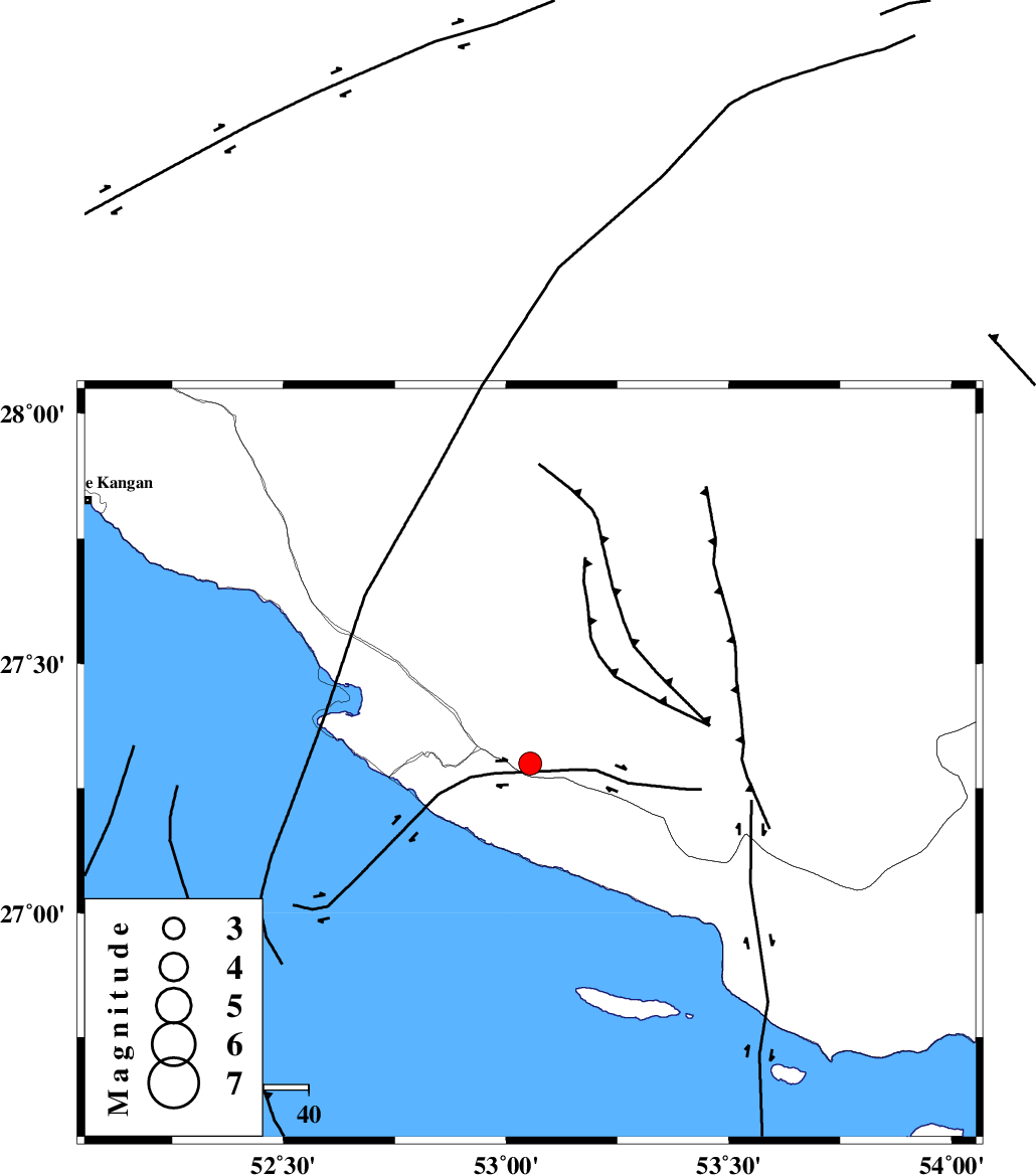
| Location | Lat:27.3 Lon: 53.054 |
| Region | Fars Province, 12 km -West of Lamerd |
Nearest Cities |
|
| 12 km West of Lamerd, Fars Province | |
| 18 km South of Khoozi, Fars Province | |
| 27 km East of Chah-e mobarak, Bushehr Province | |
| 32 km South East of Mehr, Fars Province | |
| 37 km South of Alamarvdasht, Fars Province | |
| Depth | 12 km |
| Agency | |
Faults within 150 km: |
|
| MFF3 (Length: 292 km) , Distance to epicenter: 10 km | |
| LAR_F (Length: 99 km) , Distance to epicenter: 90 km | |
| ZFF1 (Length: 165 km) , Distance to epicenter: 94 km | |
| Number of Phases | 10 |
| RMS | 0.1 |
| Number of Stations | 10 |
| Error in Latitude | >0.9 km |
| Error in Longitude | 0.9 km |
| Error in Depth | 210.1 km |
Download waveform in seisan format
to download seisan software Click here
to access information about IIEES stations Click here
Amplitude | ||||||||
| UID | Agency | Station | Component | Amplitude | Period | Arrival Time | Proccessing Time | Signal Clip |
| 199390 | IIEES SC | UOSS | Z | 0.05 | 1 | 2025-07-27 00:53:48 | 2025-10-01 06:10:00 | n |
| 199391 | IIEES SC | NASN | Z | 0.02 | 1 | 2025-07-27 00:54:13 | 2025-10-01 06:10:00 | n |
| 199392 | IIEES SC | IRSR | Z | 0.01 | 1 | 2025-07-27 00:54:33 | 2025-10-01 06:10:00 | n |
| 199393 | IIEES SC | TABS | Z | 0.009 | 1 | 2025-07-27 00:54:37 | 2025-10-01 06:10:00 | n |
Phase | ||||||||||||
| Agency | Station | Component | Phase Type | Phase Quality | First Motion | Observed Arrival Time | Time Residual | Loc. Flag | Input Weight | Distance | Azimuth | |
| IIEES SC | GHIR | Z | EPg | E | 2025-07-27 00:53:11 | 3 | n | 4 | 109 | 357 | ||
| IIEES SC | UOSS | Z | EPn | E | 2025-07-27 00:53:48 | 0.1 | y | 0 | 409 | 130 | ||
| IIEES SC | KRBR | Z | EPn | E | 2025-07-27 00:53:54 | -1.6 | n | 4 | 469 | 51 | ||
| IIEES SC | YZKH | Z | EPn | E | 2025-07-27 00:53:43 | -26.7 | n | 4 | 583 | 15 | ||
| IIEES SC | NASN | Z | EPn | E | 2025-07-27 00:54:13 | 0.1 | y | 0 | 610 | 358 | ||
| IIEES SC | IRSR | Z | EPn | E | 2025-07-27 00:54:33 | -0.2 | y | 0 | 775 | 93 | ||
| IIEES SC | TABS | Z | EPn | E | 2025-07-27 00:54:37 | -0.2 | y | 0 | 805 | 29 | ||
| IIEES SC | RAYN | Z | EPn | E | 2025-07-27 00:54:45 | 0 | y | 0 | 867 | 241 | ||
| IIEES SC | ABGH | Z | EPn | E | 2025-07-27 00:55:09 | 0.2 | y | 0 | 1059 | 9 | ||
| IIEES SC | SRSL | Z | EPn | E | 2025-07-27 00:55:29 | -0.6 | y | 0 | 1224 | 324 | ||